You are here: Home > Network List > 8G - 2016 Pedernales Earthquake Aftershock Deployment Ecuador Stations List
> Station EC20 EC20 > Earthquake Result Viewer
EC20 EC20 - Earthquake Result Viewer
| Earthquake location: |
San Juan Province, Argentina |
| Earthquake latitude/longitude: |
-31.6/-68.8 |
| Earthquake time(UTC): |
2016/11/20 (325) 20:57:43 GMT |
| Earthquake Depth: |
116 km |
| Earthquake Magnitude: |
6.4 MWP, 6.5 MWB |
| Earthquake Catalog/Contributor: |
NEIC PDE/NEIC COMCAT |
|
| Network: |
8G 2016 Pedernales Earthquake Aftershock Deployment Ecuador |
| Station: |
EC20 EC20 |
| Lat/Lon: |
1.27 S/80.43 W |
| Elevation: |
152 m |
|
| Distance: |
32.2 deg |
| Az: |
337.673 deg |
| Baz: |
161.09 deg |
| Ray Param: |
0.07845806 |
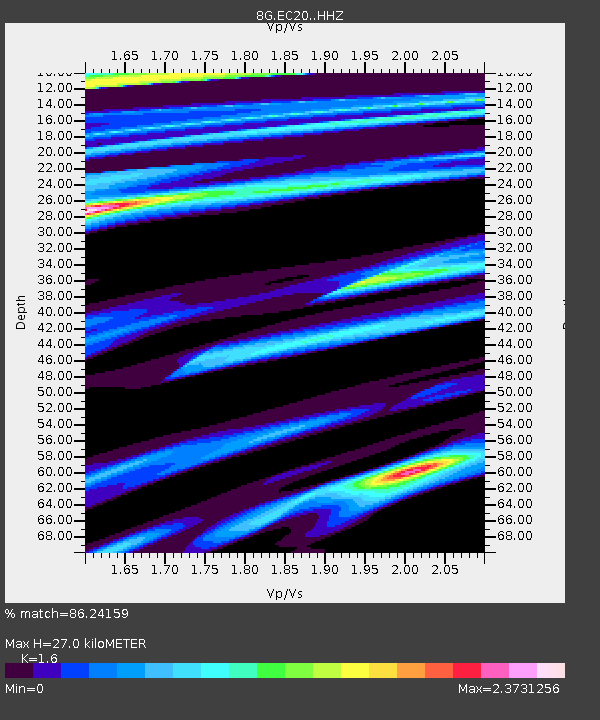
| Estimated Moho Depth: |
27.0 km |
| Estimated Crust Vp/Vs: |
1.60 |
| Assumed Crust Vp: |
6.183 km/s |
| Estimated Crust Vs: |
3.864 km/s |
| Estimated Crust Poisson's Ratio: |
0.18 |
|
| Radial Match: |
86.24159 % |
| Radial Bump: |
400 |
| Transverse Match: |
86.24161 % |
| Transverse Bump: |
400 |
| SOD ConfigId: |
11737051 |
| Insert Time: |
2019-04-26 02:48:24.601 +0000 |
| GWidth: |
2.5 |
| Max Bumps: |
400 |
| Tol: |
0.001 |
|

Signal To Noise
| Channel | StoN | STA | LTA |
| 8G:EC20: :HHZ:20161120T21:03:30.379994Z | 12.60757 | 2.727828E-6 | 2.163643E-7 |
| 8G:EC20: :HHN:20161120T21:03:30.379994Z | 3.5245643 | 1.1812028E-6 | 3.3513444E-7 |
| $trig.getChannelId() | $trig.getValue() | $trig.getSTA() | $trig.getLTA() |
| Arrivals |
| Ps | 2.8 SECOND |
| PpPs | 10 SECOND |
| PsPs/PpSs | 13 SECOND |


