
Station 8G EC20 - EC20
Network: 8G - 2016 Pedernales Earthquake Aftershock Deployment Ecuador
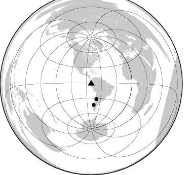
Nearby stations (2 deg radius)
| Station | Name | (Lat, Lon) | Start / End | Elevation |
| EC20 | EC20 | (-1.27, -80.43) | 2016-05-01 / 2017-05-10 | 152 m |
| Crust2 Type: | S1,continental slope, margin, transition 1 km seds. |
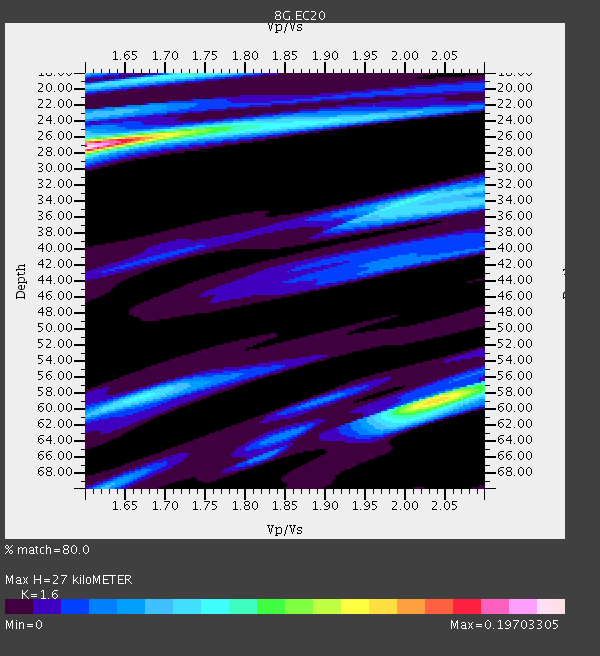
| Thickness Estimate: | 27 km |
| Thickness StdDev: | 0.1 km |
| Vp/Vs Estimate: | 1.60 |
| Vp/Vs StdDev: | 0.00 |
| Vs Estimate: | 3.864 km/s |
| Poisson's Ratio: | 0.18 |
| Peak Value: | 0.20 |
| Assumed Vp: | 6.183 km/s |
| Ps Weight: | 0.33333334 |
| PpPs Weight: | 0.33333334 |
| PsPs Weight: | 0.33333328 |
| Residual Complexity: | 0.737 |
| Nearby stations H: | +- |
| (2.0 deg) Vp/Vs: | +- |
0 with match > 90% ( 0.0 %) and 2 with match > 80% ( 6.6666665 %) out of 30.
Download stack as xyz text file.
Azimuth Distribution of Events:
Prior Results for this Station
| Study | Thickness | Vp/Vs | Vp | Vs | Poissons Ratio | Extra |
| EARS | 27 km | 1.60 | 6.183 km/s | 3.864 km/s | 0.18 | |
| Crust2.0 | 23 km | 1.81 | 6.183 km/s | 3.422 km/s | 0.28 | S1,continental slope, margin, transition 1 km seds. |
| Global Maxima | 27 km | 1.60 | 6.183 km/s | 3.864 km/s | 0.18 | amp=0.19703305 |
| Local Maxima 1 | 59 km | 2.04 | 6.183 km/s | 3.031 km/s | 0.34 | amp=0.13220927 |
| Local Maxima 2 | 34 km | 2.00 | 6.183 km/s | 3.095 km/s | 0.33 | amp=0.08378797 |
| Local Maxima 3 | 18 km | 1.73 | 6.183 km/s | 3.574 km/s | 0.25 | amp=0.074721076 |
| Local Maxima 4 | 58 km | 1.66 | 6.183 km/s | 3.713 km/s | 0.22 | amp=0.07230325 |
| Predicted Arrivals for vertical incidence (zero ray parameter) | |
| Ps | 2.62 SECOND |
| PpPs | 11.35 SECOND |
| PsPs/PpSs | 13.97 SECOND |
Events Processed for this Station
Download zip of receiver functions as SAC
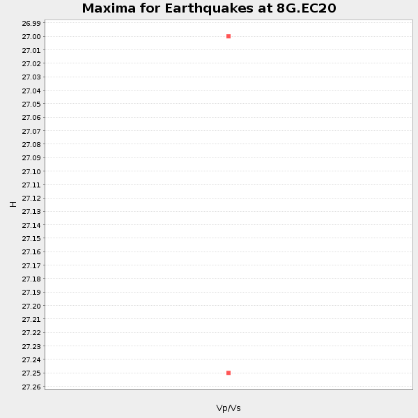
Plot maxima for each earthquake.
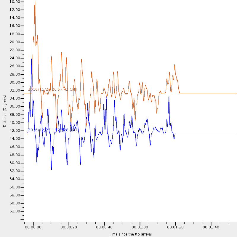
Events Used in the Stack
(2 events)| Radial Match | Distance | Baz | FERegion | Time | Lat/Lon | Depth | Magnitude |
| 86.70907 | 42.2 deg | 173.548 deg | Southern Chile | 2016/12/25 14:22:28 GMT | (-43.3, -74.5) | 15 km | 7.7 Mi |
| 86.24159 | 32.2 deg | 161.09 deg | San Juan Province, Argentina | 2016/11/20 20:57:43 GMT | (-31.6, -68.8) | 116 km | 6.4 MWP, 6.5 MWB |
Losers
(28 events)| Radial Match | Distance | Baz | FERegion | Time | Lat/Lon | Depth | Magnitude | Reason |
| 89.257614 | 66.6 deg | 152.221 deg | South Georgia Island Region | 2016/08/19 07:32:22 GMT | (-55.3, -31.9) | 10 km | 7.4 MO | |
| 84.604416 | 31.2 deg | 165.863 deg | Near Coast Of Central Chile | 2016/12/08 20:42:37 GMT | (-31.6, -71.9) | 30 km | 5.2 Mwr | |
| 84.149994 | 58.8 deg | 320.315 deg | Off Coast Of Northern California | 2016/12/08 14:49:46 GMT | (40.5, -126.2) | 12 km | 6.5 Mwb | |
| 80.62774 | 42.4 deg | 173.597 deg | Southern Chile | 2016/12/25 14:32:13 GMT | (-43.5, -74.5) | 17 km | 5.6 mb | |
| 79.71675 | 97.6 deg | 232.402 deg | Off E. Coast Of N. Island, N.Z. | 2016/09/01 17:36:00 GMT | (-37.2, 179.1) | 10 km | 5.6 MB | |
| 78.46093 | 34.8 deg | 166.373 deg | Chile-Argentina Border Region | 2016/11/04 16:20:43 GMT | (-35.1, -71.0) | 91 km | 6.4 MWP, 6.4 MWW | |
| 75.55832 | 69.5 deg | 151.324 deg | South Sandwich Islands Region | 2016/05/28 09:46:59 GMT | (-56.2, -26.9) | 73 km | 7.2 MWW, 7.3 MI | |
| 74.345924 | 31.2 deg | 309.941 deg | Off Coast Of Jalisco, Mexico | 2016/06/07 10:51:38 GMT | (18.4, -105.2) | 10 km | 6.2 MWP | |
| 73.24665 | 83.9 deg | 329.215 deg | Alaska Peninsula | 2016/07/23 09:59:00 GMT | (58.6, -156.6) | 204 km | 5.7 MB, 5.1 MI, 5.4 ML | |
| 72.051956 | 66.7 deg | 152.1 deg | South Georgia Island Region | 2016/08/21 03:45:23 GMT | (-55.3, -31.8) | 10 km | 6.4 MWP | |
| 71.05101 | 38.1 deg | 66.522 deg | Northern Mid-Atlantic Ridge | 2016/10/20 00:09:26 GMT | (13.3, -44.9) | 10 km | 5.7 MWP | |
| 70.665146 | 84.3 deg | 325.917 deg | Alaska Peninsula | 2016/05/31 20:51:22 GMT | (55.4, -158.5) | 39 km | 5.7 MWW, 5.4 MI, 5.7 MWC, 5.8 MB, 5.8 MWB | |
| 67.431046 | 41.0 deg | 53.389 deg | Northern Mid-Atlantic Ridge | 2016/09/09 17:17:54 GMT | (22.1, -45.9) | 10 km | 5.5 MB | |
| 66.54835 | 66.5 deg | 152.153 deg | South Georgia Island Region | 2016/08/19 17:33:40 GMT | (-55.2, -32.1) | 4.3 km | 5.8 MWW, 5.7 MWB, 5.8 MWC | |
| 63.464745 | 96.7 deg | 247.788 deg | South Of Fiji Islands | 2016/05/28 05:38:51 GMT | (-22.0, -178.2) | 417 km | 6.6 MO | |
| 63.297817 | 40.5 deg | 339.363 deg | Oklahoma | 2016/09/03 12:02:44 GMT | (36.4, -96.9) | 5.4 km | 5.8 MWW, 5.6 MWB, 5.7 MWR, 5.8 MWC | |
| 60.545353 | 93.4 deg | 47.332 deg | Central Italy | 2016/10/30 06:40:19 GMT | (42.9, 13.1) | 10 km | 6.6 MWW, 6.6 MWR | |
| 58.773403 | 29.8 deg | 165.258 deg | Off Coast Of Central Chile | 2016/07/19 05:18:40 GMT | (-30.2, -72.0) | 14 km | 5.5 MB | |
| 57.97108 | 64.5 deg | 205.032 deg | Southern East Pacific Rise | 2016/08/18 18:09:45 GMT | (-56.0, -123.2) | 9.5 km | 5.5 MB | |
| 57.916656 | 67.1 deg | 151.854 deg | South Sandwich Islands Region | 2016/09/02 01:57:53 GMT | (-55.3, -31.0) | 31 km | 5.6 MB | |
| 57.887325 | 93.4 deg | 47.253 deg | Central Italy | 2016/10/26 19:18:08 GMT | (42.9, 13.0) | 10 km | 6.1 MWW, 6.0 MWB, 6.1 MWR | |
| 57.33014 | 67.3 deg | 151.669 deg | South Sandwich Islands Region | 2016/08/30 15:46:02 GMT | (-55.3, -30.4) | 10 km | 5.6 MB | |
| 53.973495 | 33.0 deg | 156.568 deg | Cordoba Province, Argentina | 2016/09/09 00:03:43 GMT | (-31.4, -65.7) | 151 km | 5.6 MWR | |
| 51.917713 | 31.5 deg | 308.631 deg | Off Coast Of Jalisco, Mexico | 2016/06/02 02:23:06 GMT | (18.0, -105.9) | 10 km | 5.8 MWW, 5.8 MWC | |
| 51.57869 | 95.8 deg | 239.818 deg | Kermadec Islands, New Zealand | 2016/06/06 02:35:32 GMT | (-30.0, -177.8) | 44 km | 6.1 MWW, 6.0 MWC, 6.1 MWC | |
| 47.347225 | 93.5 deg | 47.471 deg | Central Italy | 2016/08/24 01:36:33 GMT | (42.7, 13.2) | 10 km | 6.2 MWP | |
| 46.557827 | 29.9 deg | 164.245 deg | Near Coast Of Central Chile | 2016/06/06 13:16:02 GMT | (-30.1, -71.5) | 30 km | 5.5 MWW, 5.4 MWB | |
| 34.701305 | 53.0 deg | 322.261 deg | California-Nevada Border Region | 2016/12/28 08:18:00 GMT | (38.4, -118.9) | 11 km | 5.8 ML |

