You are here: Home > Network List > Z116 - Seismic Triggering Response for Earthquakes around Wellington NZ Stations List
> Station LTW1A LTW1A, Maungakotukutuku, Paraparaumu > Earthquake Result Viewer
LTW1A LTW1A, Maungakotukutuku, Paraparaumu - Earthquake Result Viewer
| Earthquake location: |
Solomon Islands |
| Earthquake latitude/longitude: |
-10.7/161.3 |
| Earthquake time(UTC): |
2016/12/08 (343) 17:38:46 GMT |
| Earthquake Depth: |
41 km |
| Earthquake Magnitude: |
7.8 mww |
| Earthquake Catalog/Contributor: |
NEIC PDE/us |
|
| Network: |
Z1 Seismic Triggering Response for Earthquakes around Wellington NZ |
| Station: |
LTW1A LTW1A, Maungakotukutuku, Paraparaumu |
| Lat/Lon: |
40.96 S/175.05 E |
| Elevation: |
198 m |
|
| Distance: |
32.5 deg |
| Az: |
160.473 deg |
| Baz: |
334.288 deg |
| Ray Param: |
0.0785487 |
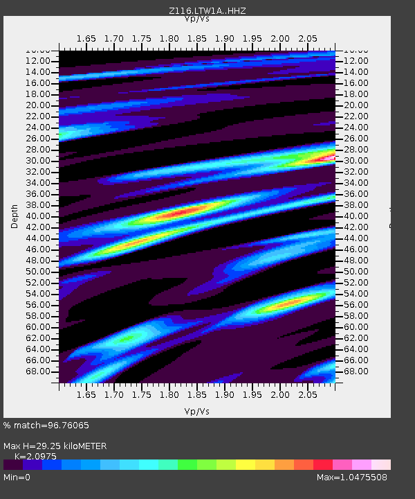
| Estimated Moho Depth: |
29.25 km |
| Estimated Crust Vp/Vs: |
2.10 |
| Assumed Crust Vp: |
6.461 km/s |
| Estimated Crust Vs: |
3.081 km/s |
| Estimated Crust Poisson's Ratio: |
0.35 |
|
| Radial Match: |
96.76065 % |
| Radial Bump: |
313 |
| Transverse Match: |
78.27017 % |
| Transverse Bump: |
400 |
| SOD ConfigId: |
11737051 |
| Insert Time: |
2019-04-26 06:08:24.506 +0000 |
| GWidth: |
2.5 |
| Max Bumps: |
400 |
| Tol: |
0.001 |
|

Signal To Noise
| Channel | StoN | STA | LTA |
| Z1:LTW1A: :HHZ:20161208T17:44:42.959987Z | 34.05667 | 2.450497E-5 | 7.195351E-7 |
| Z1:LTW1A: :HHN:20161208T17:44:42.959987Z | 18.38678 | 1.1763749E-5 | 6.3979394E-7 |
| Z1:LTW1A: :HHE:20161208T17:44:42.959987Z | 19.721546 | 7.4143923E-6 | 3.759539E-7 |
| Arrivals |
| Ps | 5.3 SECOND |
| PpPs | 13 SECOND |
| PsPs/PpSs | 18 SECOND |


