You are here: Home > Network List > Z116 - Seismic Triggering Response for Earthquakes around Wellington NZ Stations List
> Station S029 S029, Hoorkiwi, Petone > Earthquake Result Viewer
S029 S029, Hoorkiwi, Petone - Earthquake Result Viewer
| Earthquake location: |
Solomon Islands |
| Earthquake latitude/longitude: |
-10.7/161.3 |
| Earthquake time(UTC): |
2016/12/08 (343) 17:38:46 GMT |
| Earthquake Depth: |
41 km |
| Earthquake Magnitude: |
7.8 mww |
| Earthquake Catalog/Contributor: |
NEIC PDE/us |
|
| Network: |
Z1 Seismic Triggering Response for Earthquakes around Wellington NZ |
| Station: |
S029 S029, Hoorkiwi, Petone |
| Lat/Lon: |
41.20 S/174.85 E |
| Elevation: |
288 m |
|
| Distance: |
32.7 deg |
| Az: |
160.924 deg |
| Baz: |
334.803 deg |
| Ray Param: |
0.07848552 |
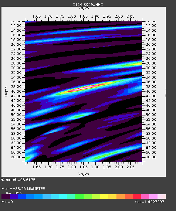
| Estimated Moho Depth: |
38.25 km |
| Estimated Crust Vp/Vs: |
1.86 |
| Assumed Crust Vp: |
6.461 km/s |
| Estimated Crust Vs: |
3.483 km/s |
| Estimated Crust Poisson's Ratio: |
0.30 |
|
| Radial Match: |
95.6175 % |
| Radial Bump: |
378 |
| Transverse Match: |
70.60248 % |
| Transverse Bump: |
400 |
| SOD ConfigId: |
11737051 |
| Insert Time: |
2019-04-26 06:08:27.795 +0000 |
| GWidth: |
2.5 |
| Max Bumps: |
400 |
| Tol: |
0.001 |
|

Signal To Noise
| Channel | StoN | STA | LTA |
| Z1:S029: :HHZ:20161208T17:44:44.249995Z | 32.745296 | 2.3717565E-5 | 7.2430447E-7 |
| Z1:S029: :HHN:20161208T17:44:44.249995Z | 17.210466 | 1.1927392E-5 | 6.930313E-7 |
| Z1:S029: :HHE:20161208T17:44:44.249995Z | 13.22589 | 5.252204E-6 | 3.9711534E-7 |
| Arrivals |
| Ps | 5.5 SECOND |
| PpPs | 16 SECOND |
| PsPs/PpSs | 21 SECOND |


