
Station Z1 S029 - S029, Hoorkiwi, Petone
Network: Z116 - Seismic Triggering Response for Earthquakes around Wellington NZ
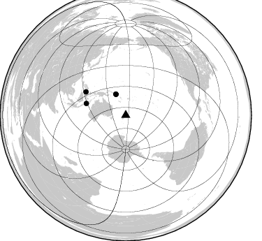
Nearby stations (2 deg radius)
| Station | Name | (Lat, Lon) | Start / End | Elevation |
| S029 | S029, Hoorkiwi, Petone | (-41.20, 174.85) | 2016-11-15 / 2017-06-01 | 288 m |
| Crust2 Type: | K2,forearc, New Zealand, 0.7 km seds. |
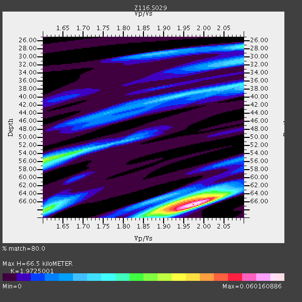
| Thickness Estimate: | 66 km |
| Thickness StdDev: | 4.1 km |
| Vp/Vs Estimate: | 1.97 |
| Vp/Vs StdDev: | 0.10 |
| Vs Estimate: | 3.276 km/s |
| Poisson's Ratio: | 0.33 |
| Peak Value: | 0.06 |
| Assumed Vp: | 6.461 km/s |
| Ps Weight: | 0.33333334 |
| PpPs Weight: | 0.33333334 |
| PsPs Weight: | 0.33333328 |
| Residual Complexity: | 0.729 |
| Nearby stations H: | +- |
| (2.0 deg) Vp/Vs: | +- |
1 with match > 90% ( 6.25 %) and 4 with match > 80% ( 25.0 %) out of 16.
Download stack as xyz text file.
Azimuth Distribution of Events:
Prior Results for this Station
| Study | Thickness | Vp/Vs | Vp | Vs | Poissons Ratio | Extra |
| EARS | 66 km | 1.97 | 6.461 km/s | 3.276 km/s | 0.33 | |
| Crust2.0 | 35 km | 1.76 | 6.461 km/s | 3.663 km/s | 0.26 | K2,forearc, New Zealand, 0.7 km seds. |
| Global Maxima | 66 km | 1.97 | 6.461 km/s | 3.276 km/s | 0.33 | amp=0.060160886 |
| Local Maxima 1 | 56 km | 1.60 | 6.461 km/s | 4.038 km/s | 0.18 | amp=0.033962235 |
| Local Maxima 2 | 66 km | 1.93 | 6.461 km/s | 3.352 km/s | 0.32 | amp=0.03261735 |
| Local Maxima 3 | 68 km | 1.60 | 6.461 km/s | 4.032 km/s | 0.18 | amp=0.03243993 |
| Local Maxima 4 | 27 km | 2.10 | 6.461 km/s | 3.081 km/s | 0.35 | amp=0.026604788 |
| Predicted Arrivals for vertical incidence (zero ray parameter) | |
| Ps | 10.01 SECOND |
| PpPs | 30.59 SECOND |
| PsPs/PpSs | 40.60 SECOND |
Events Processed for this Station
Download zip of receiver functions as SAC
Plot maxima for each earthquake.
Events Used in the Stack
(4 events)| Radial Match | Distance | Baz | FERegion | Time | Lat/Lon | Depth | Magnitude |
| 95.6175 | 32.7 deg | 334.803 deg | Solomon Islands | 2016/12/08 17:38:46 GMT | (-10.7, 161.3) | 41 km | 7.8 mww |
| 84.371315 | 65.7 deg | 300.268 deg | Celebes Sea | 2017/01/10 06:13:48 GMT | (4.4, 122.7) | 622 km | 6.9 Mi |
| 80.86589 | 33.3 deg | 334.612 deg | Solomon Islands | 2017/01/10 15:27:15 GMT | (-10.1, 161.0) | 28 km | 6.3 Mww |
| 80.85642 | 58.9 deg | 286.427 deg | Sumbawa Region, Indonesia | 2016/12/29 22:30:18 GMT | (-9.1, 118.6) | 72 km | 6.2 Mwp |
Losers
(12 events)| Radial Match | Distance | Baz | FERegion | Time | Lat/Lon | Depth | Magnitude | Reason |
| 96.44637 | 41.2 deg | 326.731 deg | New Ireland Region, P.N.G. | 2016/12/17 10:51:11 GMT | (-4.5, 153.6) | 73 km | 8.0 Mi | |
| 91.06857 | 75.3 deg | 135.063 deg | Southern Chile | 2016/12/25 14:22:28 GMT | (-43.3, -74.5) | 15 km | 7.7 Mi | |
| 75.23702 | 53.4 deg | 295.512 deg | Banda Sea | 2016/12/21 00:17:15 GMT | (-7.5, 127.9) | 152 km | 6.7 Mww | |
| 73.985275 | 33.1 deg | 334.881 deg | Solomon Islands | 2016/12/20 04:21:28 GMT | (-10.2, 161.2) | 11 km | 6.4 mww | |
| 73.47791 | 32.4 deg | 334.798 deg | Solomon Islands | 2016/12/09 21:38:23 GMT | (-10.9, 161.4) | 10 km | 5.8 Mww | |
| 63.116116 | 33.1 deg | 334.841 deg | Solomon Islands | 2016/12/18 05:46:25 GMT | (-10.2, 161.2) | 39 km | 6.0 Mwp | |
| 62.61454 | 68.1 deg | 330.433 deg | Mariana Islands Region | 2016/12/21 16:43:58 GMT | (21.5, 145.4) | 17 km | 5.9 Mwb | |
| 60.729645 | 39.8 deg | 327.256 deg | Solomon Islands | 2016/12/10 16:24:36 GMT | (-5.7, 154.5) | 157 km | 6.1 Mwp | |
| 58.46918 | 33.3 deg | 334.426 deg | Solomon Islands | 2016/12/20 12:33:15 GMT | (-10.2, 160.9) | 12 km | 5.9 mb | |
| 57.03059 | 33.0 deg | 334.992 deg | Solomon Islands | 2016/12/10 02:38:21 GMT | (-10.3, 161.3) | 36 km | 5.6 Mwp | |
| 53.684082 | 37.8 deg | 327.926 deg | Solomon Islands | 2017/03/04 02:58:24 GMT | (-7.4, 155.7) | 54 km | 5.9 Mww | |
| 43.322838 | 75.1 deg | 135.205 deg | Southern Chile | 2016/12/25 14:32:13 GMT | (-43.5, -74.5) | 17 km | 5.6 mb |

