You are here: Home > Network List > AK - Alaska Regional Network Stations List
> Station BAL Baldy Mountain > Earthquake Result Viewer
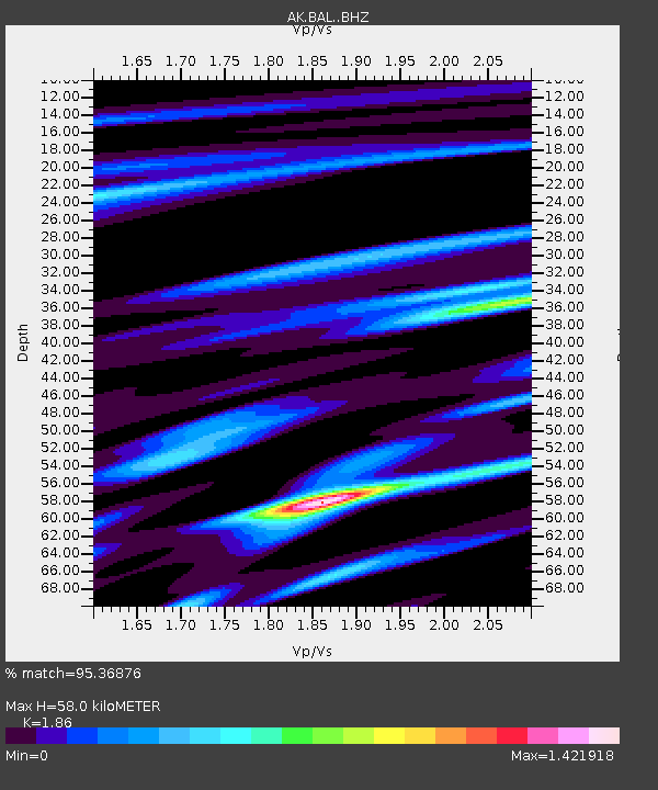
BAL Baldy Mountain - Earthquake Result Viewer
| Earthquake location: |
Solomon Islands |
| Earthquake latitude/longitude: |
-6.2/155.1 |
| Earthquake time(UTC): |
2017/01/22 (022) 04:30:23 GMT |
| Earthquake Depth: |
136 km |
| Earthquake Magnitude: |
7.9 mww |
| Earthquake Catalog/Contributor: |
NEIC PDE/us |
|
| Network: |
AK Alaska Regional Network |
| Station: |
BAL Baldy Mountain |
| Lat/Lon: |
61.04 N/142.34 W |
| Elevation: |
1341 m |
|
| Distance: |
82.6 deg |
| Az: |
25.82 deg |
| Baz: |
242.823 deg |
| Ray Param: |
0.0464843 |
| Estimated Moho Depth: |
58.0 km |
| Estimated Crust Vp/Vs: |
1.86 |
| Assumed Crust Vp: |
6.566 km/s |
| Estimated Crust Vs: |
3.53 km/s |
| Estimated Crust Poisson's Ratio: |
0.30 |
|
| Radial Match: |
95.36876 % |
| Radial Bump: |
397 |
| Transverse Match: |
89.999466 % |
| Transverse Bump: |
400 |
| SOD ConfigId: |
11737051 |
| Insert Time: |
2019-04-26 16:36:57.911 +0000 |
| GWidth: |
2.5 |
| Max Bumps: |
400 |
| Tol: |
0.001 |
|

Signal To Noise
| Channel | StoN | STA | LTA |
| AK:BAL: :BHZ:20170122T04:41:59.767991Z | 17.16759 | 1.7376826E-5 | 1.0121879E-6 |
| AK:BAL: :BHN:20170122T04:41:59.767991Z | 12.065542 | 3.5356518E-6 | 2.9303715E-7 |
| AK:BAL: :BHE:20170122T04:41:59.767991Z | 17.842974 | 6.7896462E-6 | 3.8052212E-7 |
| Arrivals |
| Ps | 7.8 SECOND |
| PpPs | 25 SECOND |
| PsPs/PpSs | 32 SECOND |


