You are here: Home > Network List > GS - US Geological Survey Networks Stations List
> Station OK053 SW of W Deep Rock Rd and N Kings Hwy, Cushing, OK, USA > Earthquake Result Viewer
OK053 SW of W Deep Rock Rd and N Kings Hwy, Cushing, OK, USA - Earthquake Result Viewer
| Earthquake location: |
Southern Bolivia |
| Earthquake latitude/longitude: |
-19.3/-63.9 |
| Earthquake time(UTC): |
2017/02/21 (052) 14:09:04 GMT |
| Earthquake Depth: |
598 km |
| Earthquake Magnitude: |
6.5 Mww |
| Earthquake Catalog/Contributor: |
NEIC PDE/us |
|
| Network: |
GS US Geological Survey Networks |
| Station: |
OK053 SW of W Deep Rock Rd and N Kings Hwy, Cushing, OK, USA |
| Lat/Lon: |
36.01 N/96.79 W |
| Elevation: |
280 m |
|
| Distance: |
63.2 deg |
| Az: |
330.447 deg |
| Baz: |
144.925 deg |
| Ray Param: |
0.057438105 |
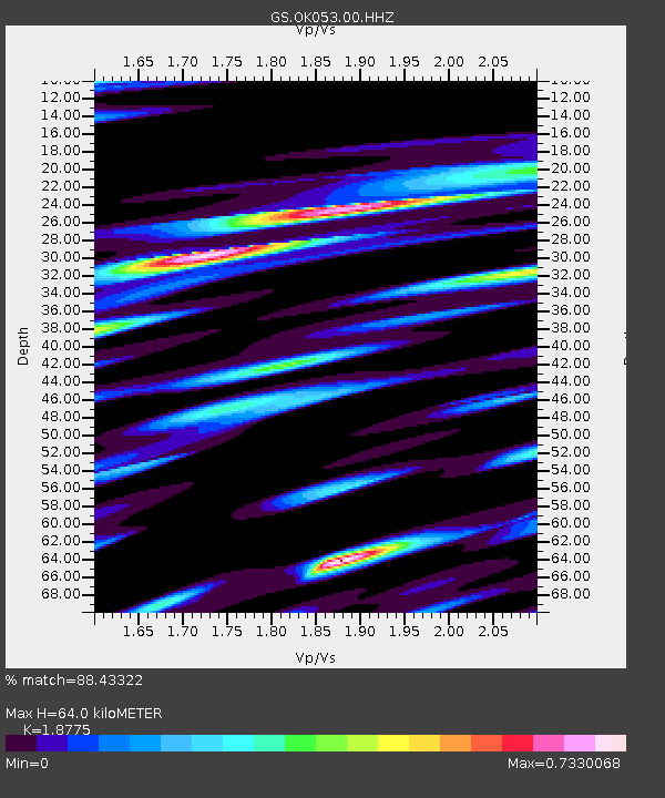
| Estimated Moho Depth: |
64.0 km |
| Estimated Crust Vp/Vs: |
1.88 |
| Assumed Crust Vp: |
6.483 km/s |
| Estimated Crust Vs: |
3.453 km/s |
| Estimated Crust Poisson's Ratio: |
0.30 |
|
| Radial Match: |
88.43322 % |
| Radial Bump: |
371 |
| Transverse Match: |
68.19135 % |
| Transverse Bump: |
400 |
| SOD ConfigId: |
11737051 |
| Insert Time: |
2019-04-26 19:27:35.747 +0000 |
| GWidth: |
2.5 |
| Max Bumps: |
400 |
| Tol: |
0.001 |
|

Signal To Noise
| Channel | StoN | STA | LTA |
| GS:OK053:00:HHZ:20170221T14:18:04.444973Z | 29.932379 | 3.232824E-6 | 1.08004244E-7 |
| GS:OK053:00:HH1:20170221T14:18:04.444973Z | 6.5700216 | 1.1877719E-6 | 1.807866E-7 |
| GS:OK053:00:HH2:20170221T14:18:04.444973Z | 5.611227 | 9.876453E-7 | 1.7601236E-7 |
| Arrivals |
| Ps | 9.0 SECOND |
| PpPs | 27 SECOND |
| PsPs/PpSs | 36 SECOND |


