
Station GS OK053 - SW of W Deep Rock Rd and N Kings Hwy, Cushing, OK, USA
Network: GS - US Geological Survey Networks
Nearby stations (2 deg radius)
| Station | Name | (Lat, Lon) | Start / End | Elevation |
| OK053 | SW of W Deep Rock Rd and N Kings Hwy, Cushing, OK, USA | (36.01, -96.79) | 2016-11-09 / 2599-12-31 | 280 m |
| Crust2 Type: | D5,thick Platform 2 km seds. |
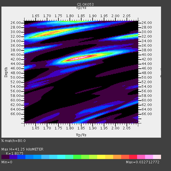
| Thickness Estimate: | 41 km |
| Thickness StdDev: | 10 km |
| Vp/Vs Estimate: | 1.84 |
| Vp/Vs StdDev: | 0.08 |
| Vs Estimate: | 3.528 km/s |
| Poisson's Ratio: | 0.29 |
| Peak Value: | 0.03 |
| Assumed Vp: | 6.483 km/s |
| Ps Weight: | 0.33333334 |
| PpPs Weight: | 0.33333334 |
| PsPs Weight: | 0.33333328 |
| Residual Complexity: | 0.728 |
| Nearby stations H: | +- |
| (2.0 deg) Vp/Vs: | +- |
2 with match > 90% ( 8.695652 %) and 4 with match > 80% ( 17.391304 %) out of 23.
Download stack as xyz text file.
Azimuth Distribution of Events:

Prior Results for this Station
| Study | Thickness | Vp/Vs | Vp | Vs | Poissons Ratio | Extra |
| EARS | 41 km | 1.84 | 6.483 km/s | 3.528 km/s | 0.29 | |
| Crust2.0 | 46 km | 1.78 | 6.483 km/s | 3.648 km/s | 0.27 | D5,thick Platform 2 km seds. |
| Global Maxima | 41 km | 1.84 | 6.483 km/s | 3.528 km/s | 0.29 | amp=0.032712772 |
| Local Maxima 1 | 31 km | 1.70 | 6.483 km/s | 3.819 km/s | 0.23 | amp=0.026119623 |
| Local Maxima 2 | 25 km | 1.79 | 6.483 km/s | 3.627 km/s | 0.27 | amp=0.018148122 |
| Local Maxima 3 | 32 km | 2.07 | 6.483 km/s | 3.135 km/s | 0.35 | amp=0.01713452 |
| Local Maxima 4 | 29 km | 1.77 | 6.483 km/s | 3.668 km/s | 0.26 | amp=0.014324728 |
| Predicted Arrivals for vertical incidence (zero ray parameter) | |
| Ps | 5.33 SECOND |
| PpPs | 18.06 SECOND |
| PsPs/PpSs | 23.38 SECOND |
Events Processed for this Station
Download zip of receiver functions as SAC
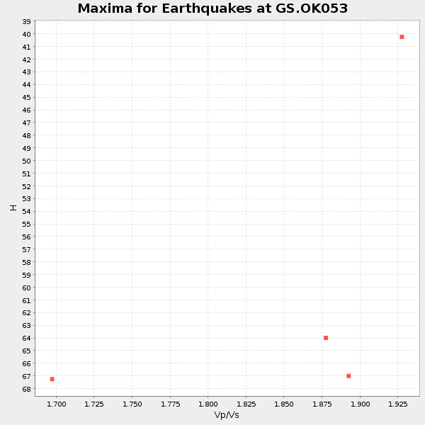
Plot maxima for each earthquake.
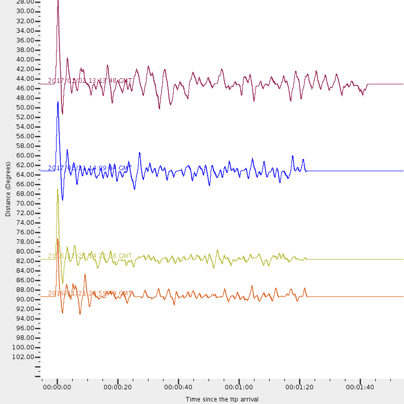
Events Used in the Stack
(4 events)| Radial Match | Distance | Baz | FERegion | Time | Lat/Lon | Depth | Magnitude |
| 97.01774 | 81.5 deg | 163.743 deg | Southern Chile | 2016/12/25 14:22:28 GMT | (-43.3, -74.5) | 15 km | 7.7 Mi |
| 92.6263 | 89.2 deg | 317.398 deg | Near East Coast Of Honshu, Japan | 2016/11/21 20:59:49 GMT | (37.4, 141.4) | 11 km | 6.9 MWB, 7.3 MI |
| 88.43322 | 63.2 deg | 144.925 deg | Southern Bolivia | 2017/02/21 14:09:04 GMT | (-19.3, -63.9) | 598 km | 6.5 Mww |
| 81.88257 | 45.0 deg | 150.498 deg | Northern Peru | 2017/01/02 13:13:48 GMT | (-4.9, -76.3) | 108 km | 5.9 Mwb |
Losers
(19 events)| Radial Match | Distance | Baz | FERegion | Time | Lat/Lon | Depth | Magnitude | Reason |
| 85.108955 | 71.2 deg | 157.704 deg | Near Coast Of Central Chile | 2016/12/08 20:42:37 GMT | (-31.6, -71.9) | 30 km | 5.2 Mwr | |
| 74.16531 | 51.8 deg | 146.913 deg | Peru-Brazil Border Region | 2016/12/18 13:30:11 GMT | (-10.0, -71.0) | 619 km | 6.4 Mww | |
| 73.77925 | 66.1 deg | 149.858 deg | Jujuy Province, Argentina | 2017/02/18 12:10:15 GMT | (-23.9, -66.7) | 201 km | 6.3 Mww | |
| 66.58641 | 38.5 deg | 113.291 deg | Leeward Islands | 2017/02/03 19:54:21 GMT | (15.1, -60.5) | 35 km | 5.6 Mwb | |
| 65.49804 | 38.5 deg | 1.959 deg | Queen Elizabeth Islands, Canada | 2017/01/08 23:47:12 GMT | (74.3, -92.3) | 19 km | 5.8 Mwp | |
| 64.874504 | 56.7 deg | 149.623 deg | Southern Peru | 2016/12/01 22:40:26 GMT | (-15.3, -70.8) | 10 km | 6.3 Mww | |
| 64.51635 | 68.2 deg | 322.124 deg | Near East Coast Of Kamchatka | 2016/11/25 07:26:23 GMT | (54.4, 160.6) | 84 km | 5.5 MB | |
| 64.17528 | 38.3 deg | 142.676 deg | Colombia | 2017/02/06 13:02:45 GMT | (3.4, -74.7) | 38 km | 5.5 Mww | |
| 63.584755 | 79.1 deg | 44.954 deg | Central Italy | 2017/01/18 10:14:11 GMT | (42.6, 13.2) | 10 km | 5.7 mb | |
| 60.999176 | 91.1 deg | 245.814 deg | Tonga Islands Region | 2016/11/16 00:30:28 GMT | (-20.2, -173.0) | 10 km | 5.9 MB, 5.6 MWB | |
| 55.943092 | 63.8 deg | 152.31 deg | Northern Chile | 2017/01/11 21:58:17 GMT | (-22.8, -69.9) | 69 km | 5.9 Mww | |
| 53.778324 | 69.6 deg | 152.372 deg | La Rioja Province, Argentina | 2016/11/13 01:01:51 GMT | (-28.1, -67.3) | 121 km | 5.7 MB | |
| 51.301537 | 79.1 deg | 44.958 deg | Central Italy | 2017/01/18 10:25:25 GMT | (42.6, 13.2) | 10 km | 5.6 Mww | |
| 50.90727 | 81.7 deg | 168.646 deg | Off Coast Of Southern Chile | 2017/02/28 17:35:40 GMT | (-44.8, -80.9) | 10 km | 5.6 Mww | |
| 48.57545 | 70.2 deg | 152.84 deg | La Rioja Province, Argentina | 2016/11/13 14:01:01 GMT | (-28.9, -67.5) | 110 km | 6.2 MB, 5.7 MWR | |
| 48.513535 | 93.9 deg | 250.725 deg | Fiji Islands Region | 2017/02/24 23:46:45 GMT | (-18.0, -178.5) | 581 km | 5.9 Mww | |
| 45.654453 | 54.8 deg | 312.818 deg | Andreanof Islands, Aleutian Is. | 2017/03/01 10:39:49 GMT | (52.2, -173.4) | 58 km | 5.5 mb | |
| 41.000942 | 34.5 deg | 145.406 deg | Near West Coast Of Colombia | 2017/01/12 16:06:31 GMT | (6.1, -77.9) | 3.3 km | 5.5 mb | |
| 39.447037 | 34.3 deg | 127.453 deg | Near Coast Of Venezuela | 2017/03/10 13:46:39 GMT | (12.0, -69.6) | 10 km | 5.5 mb |

