You are here: Home > Network List > K5 - Bhutan Seismic Network Stations List
> Station MONG Mongar Seismic Station > Earthquake Result Viewer
MONG Mongar Seismic Station - Earthquake Result Viewer
| Earthquake location: |
Sea Of Japan |
| Earthquake latitude/longitude: |
40.9/131.6 |
| Earthquake time(UTC): |
2017/07/12 (193) 19:48:07 GMT |
| Earthquake Depth: |
538 km |
| Earthquake Magnitude: |
5.8 Mww |
| Earthquake Catalog/Contributor: |
NEIC PDE/us |
|
| Network: |
K5 Bhutan Seismic Network |
| Station: |
MONG Mongar Seismic Station |
| Lat/Lon: |
27.26 N/91.16 E |
| Elevation: |
863 m |
|
| Distance: |
35.9 deg |
| Az: |
260.599 deg |
| Baz: |
57.208 deg |
| Ray Param: |
0.074382484 |
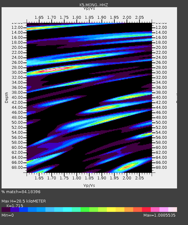
| Estimated Moho Depth: |
28.5 km |
| Estimated Crust Vp/Vs: |
1.72 |
| Assumed Crust Vp: |
6.481 km/s |
| Estimated Crust Vs: |
3.779 km/s |
| Estimated Crust Poisson's Ratio: |
0.24 |
|
| Radial Match: |
84.18396 % |
| Radial Bump: |
378 |
| Transverse Match: |
84.7509 % |
| Transverse Bump: |
400 |
| SOD ConfigId: |
13570011 |
| Insert Time: |
2019-04-28 09:05:13.182 +0000 |
| GWidth: |
2.5 |
| Max Bumps: |
400 |
| Tol: |
0.001 |
|

Signal To Noise
| Channel | StoN | STA | LTA |
| K5:MONG: :HHZ:20170712T19:53:51.490001Z | 91.64068 | 5.500044E-6 | 6.00175E-8 |
| K5:MONG: :HHN:20170712T19:53:51.490001Z | 19.17122 | 1.5416796E-6 | 8.041635E-8 |
| K5:MONG: :HHE:20170712T19:53:51.490001Z | 40.032722 | 2.3468954E-6 | 5.8624426E-8 |
| Arrivals |
| Ps | 3.4 SECOND |
| PpPs | 11 SECOND |
| PsPs/PpSs | 14 SECOND |


