
Station K5 MONG - Mongar Seismic Station
Network: K5 - Bhutan Seismic Network
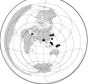
Nearby stations (2 deg radius)

| Station | Name | (Lat, Lon) | Start / End | Elevation |
| MONG | Mongar Seismic Station | (27.26, 91.16) | 2017-06-25 / 2599-12-31 | 863 m |
| Crust2 Type: | R2,orogen/65km Bolivia, 0.5 km seds. |
| Thickness Estimate: | 25 km |
| Thickness StdDev: | 12 km |
| Vp/Vs Estimate: | 2.07 |
| Vp/Vs StdDev: | 0.16 |
| Vs Estimate: | 3.138 km/s |
| Poisson's Ratio: | 0.35 |
| Peak Value: | 0.02 |
| Assumed Vp: | 6.481 km/s |
| Ps Weight: | 0.33333334 |
| PpPs Weight: | 0.33333334 |
| PsPs Weight: | 0.33333328 |
| Residual Complexity: | 0.813 |
| Nearby stations H: | +- |
| (2.0 deg) Vp/Vs: | +- |
0 with match > 90% ( 0.0 %) and 12 with match > 80% ( 41.37931 %) out of 29.
Download stack as xyz text file.
Azimuth Distribution of Events:
Prior Results for this Station
| Study | Thickness | Vp/Vs | Vp | Vs | Poissons Ratio | Extra |
| EARS | 25 km | 2.07 | 6.481 km/s | 3.138 km/s | 0.35 | |
| Crust2.0 | 65 km | 1.76 | 6.481 km/s | 3.685 km/s | 0.26 | R2,orogen/65km Bolivia, 0.5 km seds. |
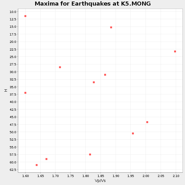
| Global Maxima | 25 km | 2.07 | 6.481 km/s | 3.138 km/s | 0.35 | amp=0.02015901 |
| Local Maxima 1 | 44 km | 1.89 | 6.481 km/s | 3.429 km/s | 0.31 | amp=0.015160251 |
| Local Maxima 2 | 60 km | 1.66 | 6.481 km/s | 3.904 km/s | 0.22 | amp=0.012952673 |
| Local Maxima 3 | 40 km | 1.97 | 6.481 km/s | 3.286 km/s | 0.33 | amp=0.010689706 |
| Local Maxima 4 | 37 km | 1.61 | 6.481 km/s | 4.025 km/s | 0.19 | amp=0.009711309 |
| Predicted Arrivals for vertical incidence (zero ray parameter) | |
| Ps | 4.11 SECOND |
| PpPs | 11.82 SECOND |
| PsPs/PpSs | 15.93 SECOND |
Events Processed for this Station
Download zip of receiver functions as SAC
Plot maxima for each earthquake.
Events Used in the Stack
(12 events)| Radial Match | Distance | Baz | FERegion | Time | Lat/Lon | Depth | Magnitude |
| 86.65349 | 43.4 deg | 63.376 deg | Near East Coast Of Honshu, Japan | 2017/07/20 00:11:25 GMT | (37.4, 141.6) | 35 km | 5.8 Mww |
| 85.46249 | 67.7 deg | 108.062 deg | New Ireland Region, P.N.G. | 2017/07/13 03:36:09 GMT | (-4.8, 153.2) | 47 km | 6.4 mww |
| 85.30564 | 35.3 deg | 110.508 deg | Leyte, Philippines | 2017/07/06 08:03:57 GMT | (11.1, 124.6) | 6.5 km | 6.5 mww |
| 84.95753 | 59.7 deg | 115.978 deg | New Guinea, Papua New Guinea | 2018/02/28 02:45:44 GMT | (-6.2, 142.5) | 10 km | 6.0 Mww |
| 84.63652 | 44.8 deg | 59.58 deg | Off East Coast Of Honshu, Japan | 2017/07/23 15:35:40 GMT | (40.0, 143.5) | 10 km | 5.6 Mww |
| 84.18396 | 35.9 deg | 57.208 deg | Sea Of Japan | 2017/07/12 19:48:07 GMT | (40.9, 131.6) | 538 km | 5.8 Mww |
| 83.470764 | 34.7 deg | 81.415 deg | Southeast Of Ryukyu Islands | 2017/07/26 10:32:57 GMT | (26.9, 130.2) | 10 km | 5.9 Mww |
| 83.32454 | 60.9 deg | 111.267 deg | Near N Coast Of New Guinea, P.N.G. | 2018/01/26 22:47:57 GMT | (-3.5, 145.8) | 10 km | 6.3 Mww |
| 83.05824 | 53.9 deg | 297.324 deg | Dodecanese Islands, Greece | 2017/07/20 22:31:12 GMT | (36.9, 27.5) | 10 km | 6.7 Mww |
| 82.59334 | 34.0 deg | 55.73 deg | North Korea | 2017/09/03 03:30:01 GMT | (41.3, 129.0) | 0.0 km | 6.3 mb |
| 82.29284 | 38.8 deg | 116.444 deg | Mindanao, Philippines | 2017/08/05 00:30:41 GMT | (6.2, 125.5) | 74 km | 5.8 Mww |
| 80.63037 | 30.5 deg | 109.614 deg | Luzon, Philippines | 2017/08/11 05:28:25 GMT | (14.0, 120.7) | 168 km | 6.2 Mww |
Losers
(17 events)| Radial Match | Distance | Baz | FERegion | Time | Lat/Lon | Depth | Magnitude | Reason |
| 95.577736 | 61.5 deg | 40.844 deg | Komandorskiye Ostrova Region | 2017/07/17 23:34:21 GMT | (54.2, 169.2) | 48 km | 7.4 Mi | |
| 79.661514 | 64.3 deg | 113.033 deg | Eastern New Guinea Reg., P.N.G. | 2017/07/07 03:42:52 GMT | (-6.7, 147.8) | 41 km | 5.7 Mww | |
| 79.400154 | 50.5 deg | 211.194 deg | Mauritius - Reunion Region | 2017/07/19 12:16:25 GMT | (-17.4, 66.4) | 10 km | 5.9 Mww | |
| 79.39108 | 53.2 deg | 92.587 deg | Mariana Islands | 2017/09/02 23:00:01 GMT | (14.0, 146.7) | 10 km | 5.5 mb | |
| 78.99642 | 53.2 deg | 92.866 deg | South Of Mariana Islands | 2018/02/11 23:14:18 GMT | (13.8, 146.5) | 42 km | 6.2 Mi | |
| 78.86477 | 34.2 deg | 161.634 deg | Southwest Of Sumatra, Indonesia | 2017/07/25 23:23:23 GMT | (-5.7, 101.4) | 10 km | 5.5 mb | |
| 77.08201 | 77.6 deg | 108.419 deg | Solomon Islands | 2017/08/06 00:15:10 GMT | (-10.3, 161.5) | 73 km | 5.7 Mww | |
| 75.98696 | 50.3 deg | 51.268 deg | Kuril Islands | 2017/07/30 21:00:49 GMT | (46.2, 151.0) | 87 km | 5.7 mb | |
| 75.06775 | 56.5 deg | 115.361 deg | Irian Jaya, Indonesia | 2017/08/14 23:49:29 GMT | (-3.9, 140.2) | 36 km | 5.5 mb | |
| 74.40593 | 61.1 deg | 40.459 deg | Komandorskiye Ostrova Region | 2017/07/17 11:05:08 GMT | (54.6, 168.6) | 7.9 km | 6.2 Mww | |
| 73.76939 | 39.9 deg | 126.871 deg | Minahassa Peninsula, Sulawesi | 2017/07/15 12:12:21 GMT | (0.4, 122.0) | 114 km | 5.9 Mww | |
| 65.08034 | 66.7 deg | 109.543 deg | New Britain Region, P.N.G. | 2017/08/07 06:26:44 GMT | (-5.4, 151.6) | 35 km | 5.8 Mww | |
| 64.32069 | 74.4 deg | 38.677 deg | Fox Islands, Aleutian Islands | 2017/08/09 05:40:42 GMT | (52.6, -169.2) | 47 km | 5.3 mb | |
| 63.535572 | 35.5 deg | 110.555 deg | Leyte, Philippines | 2017/07/10 01:41:48 GMT | (11.0, 124.8) | 7.1 km | 5.8 Mww | |
| 63.465706 | 45.4 deg | 74.766 deg | Southeast Of Honshu, Japan | 2017/07/27 23:58:52 GMT | (29.3, 143.0) | 10 km | 5.3 Mww | |
| 63.13263 | 48.2 deg | 54.541 deg | Kuril Islands | 2017/06/28 12:07:30 GMT | (43.7, 148.0) | 49 km | 5.4 Mww | |
| 62.994484 | 60.3 deg | 115.815 deg | New Guinea, Papua New Guinea | 2018/02/27 06:19:12 GMT | (-6.4, 143.0) | 10 km | 5.6 Mww |

