You are here: Home > Network List > K5 - Bhutan Seismic Network Stations List
> Station MONG Mongar Seismic Station > Earthquake Result Viewer
MONG Mongar Seismic Station - Earthquake Result Viewer
| Earthquake location: |
Off East Coast Of Honshu, Japan |
| Earthquake latitude/longitude: |
40.0/143.5 |
| Earthquake time(UTC): |
2017/07/23 (204) 15:35:40 GMT |
| Earthquake Depth: |
10 km |
| Earthquake Magnitude: |
5.6 Mww |
| Earthquake Catalog/Contributor: |
NEIC PDE/us |
|
| Network: |
K5 Bhutan Seismic Network |
| Station: |
MONG Mongar Seismic Station |
| Lat/Lon: |
27.26 N/91.16 E |
| Elevation: |
863 m |
|
| Distance: |
44.8 deg |
| Az: |
270.087 deg |
| Baz: |
59.58 deg |
| Ray Param: |
0.0716964 |
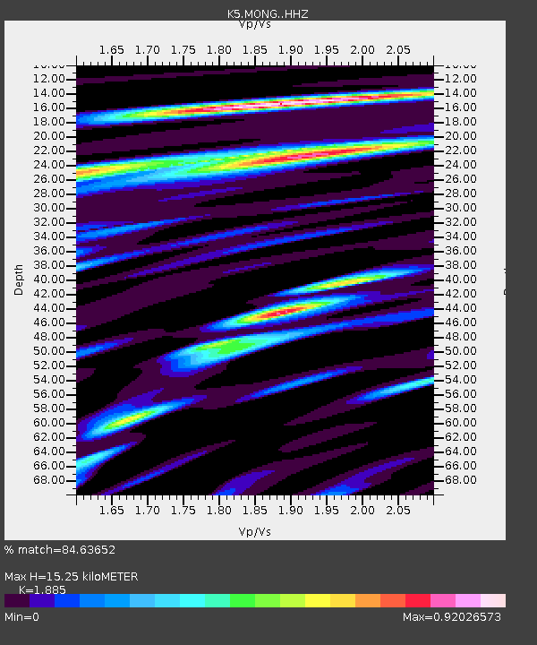
| Estimated Moho Depth: |
15.25 km |
| Estimated Crust Vp/Vs: |
1.88 |
| Assumed Crust Vp: |
6.481 km/s |
| Estimated Crust Vs: |
3.438 km/s |
| Estimated Crust Poisson's Ratio: |
0.30 |
|
| Radial Match: |
84.63652 % |
| Radial Bump: |
400 |
| Transverse Match: |
71.79174 % |
| Transverse Bump: |
400 |
| SOD ConfigId: |
13570011 |
| Insert Time: |
2019-04-28 11:11:43.726 +0000 |
| GWidth: |
2.5 |
| Max Bumps: |
400 |
| Tol: |
0.001 |
|

Signal To Noise
| Channel | StoN | STA | LTA |
| K5:MONG: :HHZ:20170723T15:43:23.889991Z | 14.554822 | 9.568918E-7 | 6.574397E-8 |
| K5:MONG: :HHN:20170723T15:43:23.889991Z | 3.3642392 | 2.551864E-7 | 7.5852626E-8 |
| K5:MONG: :HHE:20170723T15:43:23.889991Z | 7.958909 | 4.064673E-7 | 5.107073E-8 |
| Arrivals |
| Ps | 2.2 SECOND |
| PpPs | 6.4 SECOND |
| PsPs/PpSs | 8.6 SECOND |


