You are here: Home > Network List > IC - New China Digital Seismograph Network Stations List
> Station HIA Hailar, Neimenggu Autonomous Region, China > Earthquake Result Viewer
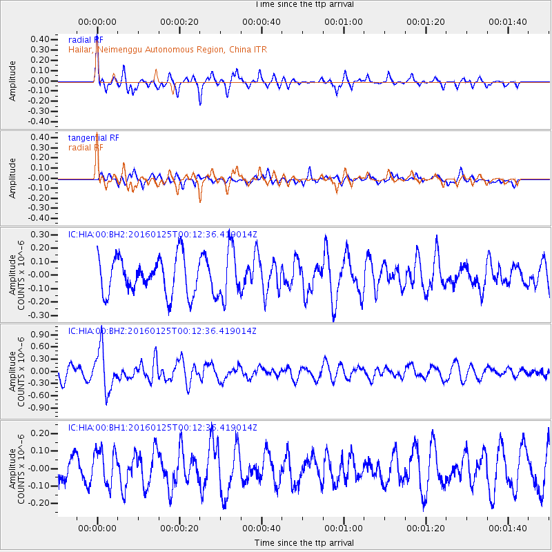
HIA Hailar, Neimenggu Autonomous Region, China - Earthquake Result Viewer
*The percent match for this event was below the threshold and hence no stack was calculated.
| Earthquake location: |
Tonga Islands |
| Earthquake latitude/longitude: |
-19.6/-173.4 |
| Earthquake time(UTC): |
2016/01/25 (025) 00:00:09 GMT |
| Earthquake Depth: |
40 km |
| Earthquake Magnitude: |
5.7 MB |
| Earthquake Catalog/Contributor: |
NEIC PDE/NEIC COMCAT |
|
| Network: |
IC New China Digital Seismograph Network |
| Station: |
HIA Hailar, Neimenggu Autonomous Region, China |
| Lat/Lon: |
49.27 N/119.74 E |
| Elevation: |
620 m |
|
| Distance: |
90.5 deg |
| Az: |
322.963 deg |
| Baz: |
119.892 deg |
| Ray Param: |
$rayparam |
*The percent match for this event was below the threshold and hence was not used in the summary stack. |
|
| Radial Match: |
60.383533 % |
| Radial Bump: |
296 |
| Transverse Match: |
61.83359 % |
| Transverse Bump: |
393 |
| SOD ConfigId: |
1399611 |
| Insert Time: |
2016-02-08 03:09:22.025 +0000 |
| GWidth: |
2.5 |
| Max Bumps: |
400 |
| Tol: |
0.001 |
|
Signal To Noise
| Channel | StoN | STA | LTA |
| IC:HIA:00:BHZ:20160125T00:12:36.419014Z | 3.883428 | 5.142336E-7 | 1.3241744E-7 |
| IC:HIA:00:BH1:20160125T00:12:36.419014Z | 1.3666842 | 1.01514324E-7 | 7.427782E-8 |
| IC:HIA:00:BH2:20160125T00:12:36.419014Z | 1.3920822 | 1.8739868E-7 | 1.3461754E-7 |
| Arrivals |
| Ps | |
| PpPs | |
| PsPs/PpSs | |


