You are here: Home > Network List > K5 - Bhutan Seismic Network Stations List
> Station MONG Mongar Seismic Station > Earthquake Result Viewer
MONG Mongar Seismic Station - Earthquake Result Viewer
| Earthquake location: |
Luzon, Philippines |
| Earthquake latitude/longitude: |
14.0/120.7 |
| Earthquake time(UTC): |
2017/08/11 (223) 05:28:25 GMT |
| Earthquake Depth: |
168 km |
| Earthquake Magnitude: |
6.2 Mww |
| Earthquake Catalog/Contributor: |
NEIC PDE/us |
|
| Network: |
K5 Bhutan Seismic Network |
| Station: |
MONG Mongar Seismic Station |
| Lat/Lon: |
27.26 N/91.16 E |
| Elevation: |
863 m |
|
| Distance: |
30.5 deg |
| Az: |
300.244 deg |
| Baz: |
109.614 deg |
| Ray Param: |
0.07896175 |
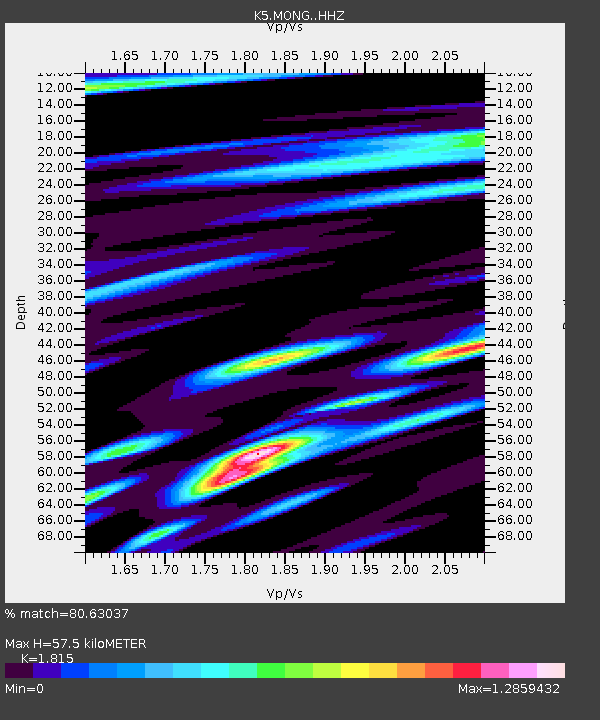
| Estimated Moho Depth: |
57.5 km |
| Estimated Crust Vp/Vs: |
1.82 |
| Assumed Crust Vp: |
6.481 km/s |
| Estimated Crust Vs: |
3.571 km/s |
| Estimated Crust Poisson's Ratio: |
0.28 |
|
| Radial Match: |
80.63037 % |
| Radial Bump: |
381 |
| Transverse Match: |
67.69789 % |
| Transverse Bump: |
400 |
| SOD ConfigId: |
13570011 |
| Insert Time: |
2019-04-28 13:55:01.504 +0000 |
| GWidth: |
2.5 |
| Max Bumps: |
400 |
| Tol: |
0.001 |
|

Signal To Noise
| Channel | StoN | STA | LTA |
| K5:MONG: :HHZ:20170811T05:33:52.519985Z | 32.490547 | 2.9990083E-6 | 9.230403E-8 |
| K5:MONG: :HHN:20170811T05:33:52.519985Z | 9.665391 | 1.0263283E-6 | 1.06185894E-7 |
| K5:MONG: :HHE:20170811T05:33:52.519985Z | 17.822792 | 1.7593242E-6 | 9.8712036E-8 |
| Arrivals |
| Ps | 7.8 SECOND |
| PpPs | 23 SECOND |
| PsPs/PpSs | 31 SECOND |


