You are here: Home > Network List > TA - USArray Transportable Network (new EarthScope stations) Stations List
> Station M01C Crescent City, CA, USA > Earthquake Result Viewer
M01C Crescent City, CA, USA - Earthquake Result Viewer
| Earthquake location: |
Near Coast Of Peru |
| Earthquake latitude/longitude: |
-13.4/-76.6 |
| Earthquake time(UTC): |
2007/08/15 (227) 23:40:57 GMT |
| Earthquake Depth: |
39 km |
| Earthquake Magnitude: |
6.7 MB, 7.9 MS, 8.0 MW, 7.5 ME |
| Earthquake Catalog/Contributor: |
WHDF/NEIC |
|
| Network: |
TA USArray Transportable Network (new EarthScope stations) |
| Station: |
M01C Crescent City, CA, USA |
| Lat/Lon: |
41.85 N/124.12 W |
| Elevation: |
38 m |
|
| Distance: |
70.2 deg |
| Az: |
324.161 deg |
| Baz: |
130.302 deg |
| Ray Param: |
0.05505034 |
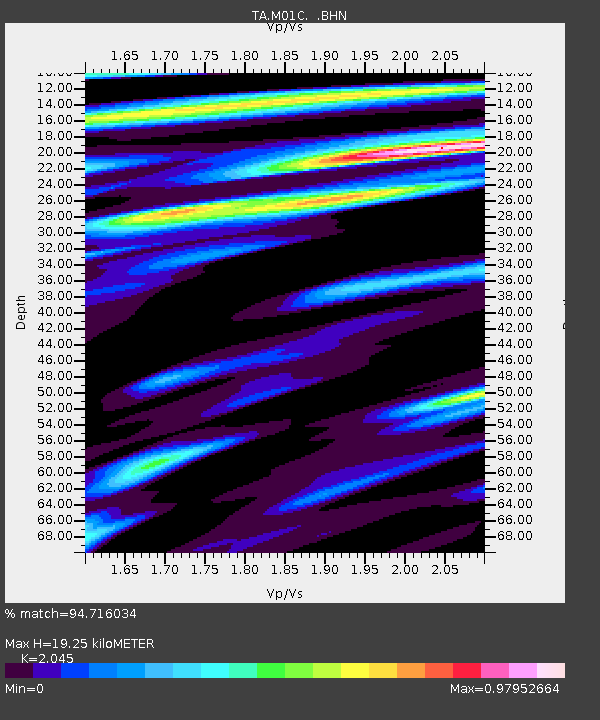
| Estimated Moho Depth: |
19.25 km |
| Estimated Crust Vp/Vs: |
2.05 |
| Assumed Crust Vp: |
6.048 km/s |
| Estimated Crust Vs: |
2.957 km/s |
| Estimated Crust Poisson's Ratio: |
0.34 |
|
| Radial Match: |
94.716034 % |
| Radial Bump: |
400 |
| Transverse Match: |
92.1742 % |
| Transverse Bump: |
400 |
| SOD ConfigId: |
2564 |
| Insert Time: |
2010-03-06 02:48:51.649 +0000 |
| GWidth: |
2.5 |
| Max Bumps: |
400 |
| Tol: |
0.001 |
|
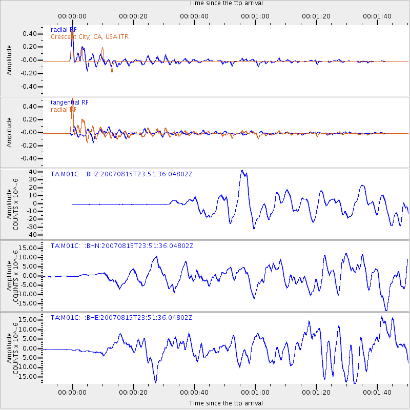
Signal To Noise
| Channel | StoN | STA | LTA |
| TA:M01C: :BHN:20070815T23:51:36.04802Z | 4.4087553 | 6.474638E-7 | 1.4685865E-7 |
| TA:M01C: :BHE:20070815T23:51:36.04802Z | 5.7499614 | 6.785419E-7 | 1.18008074E-7 |
| TA:M01C: :BHZ:20070815T23:51:36.04802Z | 15.882545 | 2.8603033E-6 | 1.8009099E-7 |
| Arrivals |
| Ps | 3.4 SECOND |
| PpPs | 9.4 SECOND |
| PsPs/PpSs | 13 SECOND |


