
Station TA M01C - Crescent City, CA, USA
Network: TA - USArray Transportable Network (new EarthScope stations)
Nearby stations (2 deg radius)
| Station | Name | (Lat, Lon) | Start / End | Elevation |
| M01C | Crescent City, CA, USA | (41.85, -124.12) | 2006-05-19 / 2499-01-01 | 0.0 km |
| Crust2 Type: | S2,continental slope, margin, transition 2 km seds. |
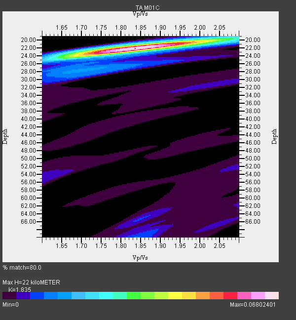
| Thickness Estimate: | 22 km |
| Thickness StdDev: | 0.3 km |
| Vp/Vs Estimate: | 1.84 |
| Vp/Vs StdDev: | 0.03 |
| Vs Estimate: | 3.296 km/s |
| Poisson's Ratio: | 0.29 |
| Peak Value: | 0.07 |
| Assumed Vp: | 6.048 km/s |
| Ps Weight: | 0.33333334 |
| PpPs Weight: | 0.33333334 |
| PsPs Weight: | 0.33333328 |
| Residual Complexity: | 0.280 |
| Nearby stations H: | +- |
| (2.0 deg) Vp/Vs: | +- |
7 with match > 90% ( 38.88889 %) and 18 with match > 80% ( 100.0 %) out of 18.
Download stack as xyz text file.
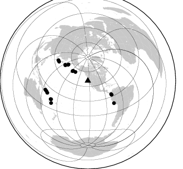
Azimuth Distribution of Events:
Prior Results for this Station
| Study | Thickness | Vp/Vs | Vp | Vs | Poissons Ratio | Extra |
| EARS | 22 km | 1.84 | 6.048 km/s | 3.296 km/s | 0.29 | |
| Crust2.0 | 24 km | 1.81 | 6.048 km/s | 3.34 km/s | 0.28 | S2,continental slope, margin, transition 2 km seds. |
| Global Maxima | 22 km | 1.84 | 6.048 km/s | 3.296 km/s | 0.29 | amp=0.06802401 |
| Local Maxima 1 | 20 km | 1.98 | 6.048 km/s | 3.062 km/s | 0.33 | amp=0.017531283 |
| Local Maxima 2 | 27 km | 1.72 | 6.048 km/s | 3.511 km/s | 0.25 | amp=0.012357688 |
| Local Maxima 3 | 24 km | 1.63 | 6.048 km/s | 3.71 km/s | 0.20 | amp=0.012039351 |
| Local Maxima 4 | 70 km | 1.84 | 6.048 km/s | 3.296 km/s | 0.29 | amp=0.0073616984 |
| Predicted Arrivals for vertical incidence (zero ray parameter) | |
| Ps | 3.04 SECOND |
| PpPs | 10.31 SECOND |
| PsPs/PpSs | 13.35 SECOND |
Events Processed for this Station
Download zip of receiver functions as SAC
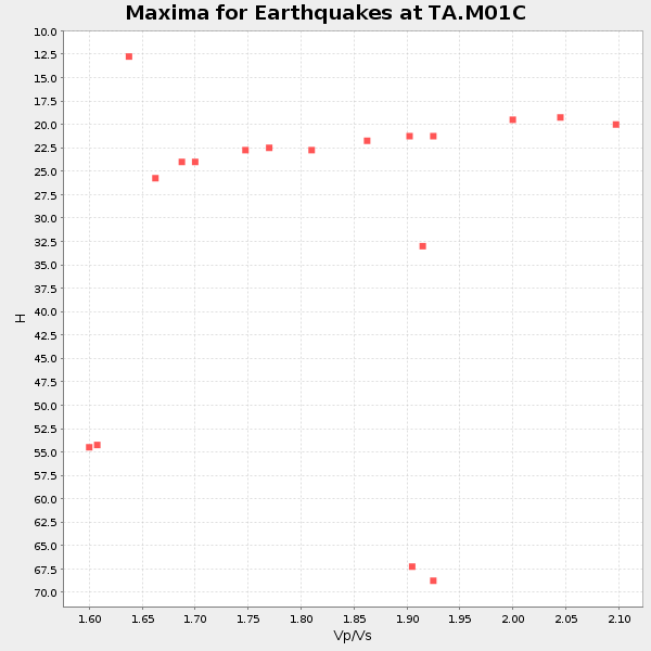
Plot maxima for each earthquake.
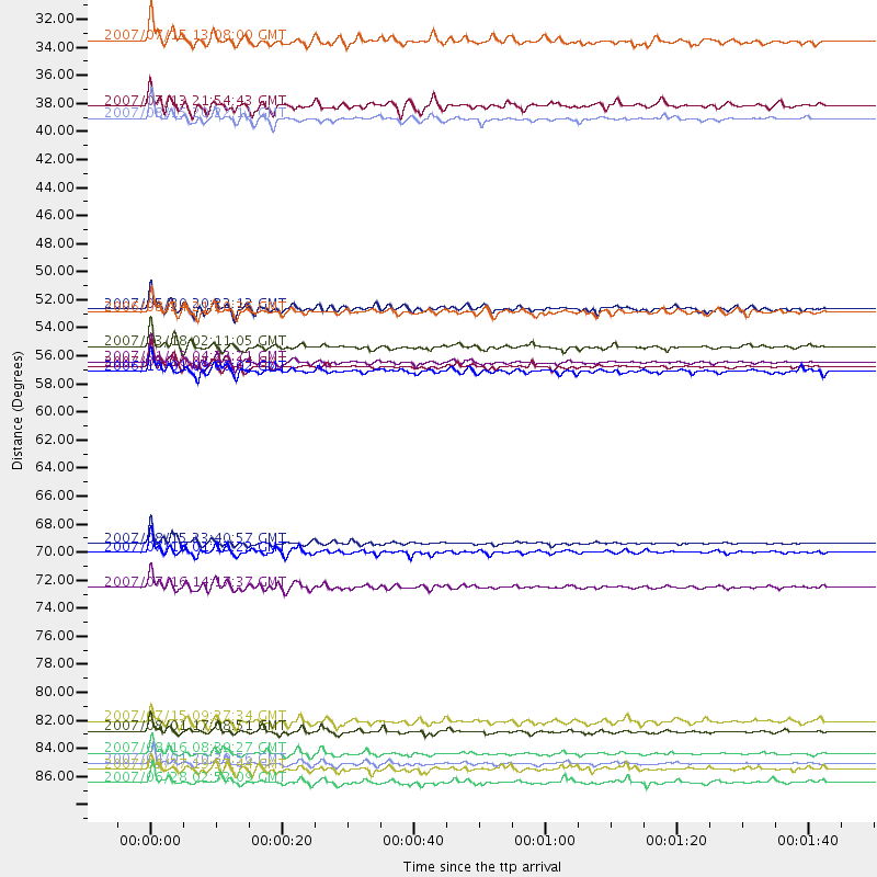
Events Used in the Stack
(18 events)| Radial Match | Distance | Baz | FERegion | Time | Lat/Lon | Depth | Magnitude |
| 97.770966 | 56.2 deg | 304.329 deg | East Of Kuril Islands | 2007/01/13 04:23:21 GMT | (46.2, 154.5) | 10 km | 7.3 MB, 8.2 MS, 8.1 MW, 7.9 MW |
| 95.26977 | 52.1 deg | 310.019 deg | Kamchatka Peninsula, Russia | 2007/05/30 20:22:12 GMT | (52.1, 157.3) | 116 km | 6.4 MB, 6.4 MW, 6.4 MW |
| 94.74919 | 87.4 deg | 256.303 deg | Solomon Islands | 2007/04/01 20:39:56 GMT | (-8.5, 157.0) | 10 km | 6.8 MB, 7.9 MS, 8.1 MW, 7.7 ME |
| 94.716034 | 70.2 deg | 130.302 deg | Near Coast Of Peru | 2007/08/15 23:40:57 GMT | (-13.4, -76.6) | 39 km | 6.7 MB, 7.9 MS, 8.0 MW, 7.5 ME |
| 93.59343 | 70.9 deg | 303.493 deg | Near West Coast Of Honshu, Japan | 2007/07/16 01:13:22 GMT | (37.5, 138.4) | 12 km | 6.5 MB, 6.4 MS, 6.6 MW, 6.5 MW |
| 92.81486 | 86.5 deg | 253.672 deg | Solomon Islands | 2007/08/16 08:39:27 GMT | (-9.8, 159.5) | 10 km | 6.1 MB, 6.7 MS, 6.4 MW |
| 90.16016 | 84.8 deg | 243.943 deg | Vanuatu Islands | 2007/08/01 17:08:51 GMT | (-15.6, 167.7) | 120 km | 6.2 MB, 7.2 MW, 7.2 MW |
| 88.87918 | 73.6 deg | 304.812 deg | Sea Of Japan | 2007/07/16 14:17:37 GMT | (36.8, 134.9) | 350 km | 6.2 MB, 6.8 MW, 6.8 MW |
| 88.12113 | 56.5 deg | 120.318 deg | Near West Coast Of Colombia | 2007/09/10 01:49:14 GMT | (3.0, -78.0) | 31 km | 6.1 MB, 6.7 MS, 6.8 MW |
| 86.51716 | 56.9 deg | 305.063 deg | Kuril Islands | 2006/10/01 09:06:02 GMT | (46.5, 153.2) | 19 km | 6.1 MB, 6.4 MS, 6.6 MW, 6.5 MW |
| 86.30413 | 37.3 deg | 301.833 deg | Andreanof Islands, Aleutian Is. | 2007/08/15 20:22:11 GMT | (50.3, -177.5) | 9.0 km | 6.3 MB, 6.2 MS, 6.4 MW, 5.9 ML |
| 85.20299 | 31.2 deg | 305.11 deg | Fox Islands, Aleutian Islands | 2007/07/15 13:08:00 GMT | (52.5, -168.0) | 10 km | 5.8 MB, 5.9 MS, 6.1 MW, 6.0 MW |
| 84.34205 | 88.8 deg | 258.281 deg | Solomon Islands | 2007/06/28 02:52:09 GMT | (-8.0, 154.6) | 10 km | 6.3 MB, 6.7 MS, 6.7 MW, 6.7 MW |
| 84.148346 | 55.0 deg | 119.56 deg | South Of Panama | 2007/03/18 02:11:05 GMT | (4.6, -78.5) | 8.0 km | 6.4 MB, 5.7 MS, 6.2 MW, 6.1 MW |
| 82.04857 | 87.8 deg | 239.045 deg | Southeast Of Loyalty Islands | 2007/09/27 19:57:44 GMT | (-21.1, 169.3) | 9.0 km | 6.2 MB, 6.3 MS, 6.1 MW, 6.1 MW |
| 81.621025 | 36.3 deg | 304.197 deg | Andreanof Islands, Aleutian Is. | 2007/07/13 21:54:43 GMT | (51.8, -176.3) | 35 km | 5.7 MB, 5.6 MS, 6.0 MW, 5.9 MW |
| 81.28874 | 84.1 deg | 243.451 deg | Vanuatu Islands | 2007/07/15 09:27:34 GMT | (-15.4, 168.6) | 8.0 km | 6.0 MB, 5.8 MS, 6.1 MW, 6.0 MW |
| 80.519295 | 52.3 deg | 308.79 deg | Near East Coast Of Kamchatka | 2006/08/24 21:50:36 GMT | (51.1, 157.5) | 43 km | 5.9 MB, 6.2 MS, 6.5 MW, 6.5 MW |
Losers
(0 events)| Radial Match | Distance | Baz | FERegion | Time | Lat/Lon | Depth | Magnitude | Reason |
