You are here: Home > Network List > TA - USArray Transportable Network (new EarthScope stations) Stations List
> Station M01C Crescent City, CA, USA > Earthquake Result Viewer
M01C Crescent City, CA, USA - Earthquake Result Viewer
| Earthquake location: |
Sea Of Japan |
| Earthquake latitude/longitude: |
36.8/134.9 |
| Earthquake time(UTC): |
2007/07/16 (197) 14:17:37 GMT |
| Earthquake Depth: |
350 km |
| Earthquake Magnitude: |
6.2 MB, 6.8 MW, 6.8 MW |
| Earthquake Catalog/Contributor: |
WHDF/NEIC |
|
| Network: |
TA USArray Transportable Network (new EarthScope stations) |
| Station: |
M01C Crescent City, CA, USA |
| Lat/Lon: |
41.85 N/124.12 W |
| Elevation: |
38 m |
|
| Distance: |
73.6 deg |
| Az: |
49.847 deg |
| Baz: |
304.812 deg |
| Ray Param: |
0.051850848 |
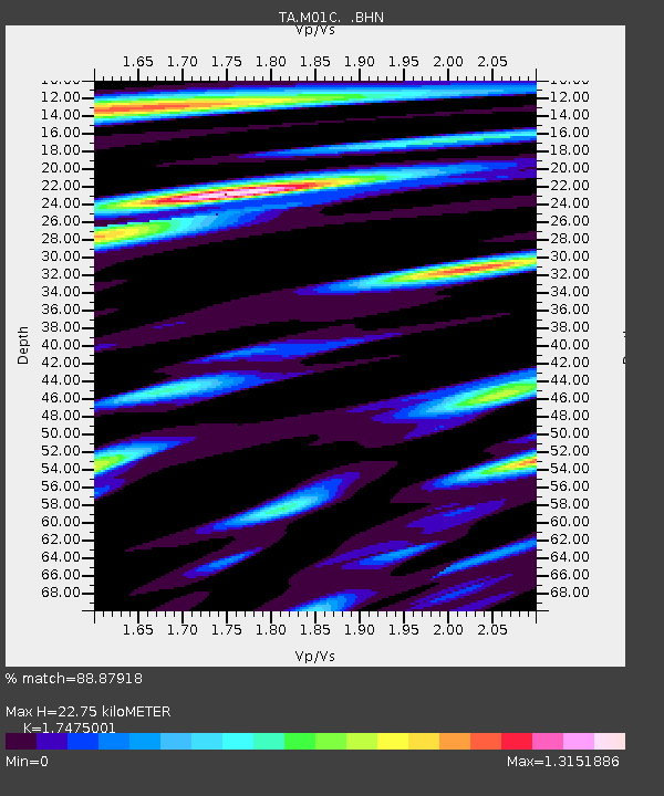
| Estimated Moho Depth: |
22.75 km |
| Estimated Crust Vp/Vs: |
1.75 |
| Assumed Crust Vp: |
6.048 km/s |
| Estimated Crust Vs: |
3.461 km/s |
| Estimated Crust Poisson's Ratio: |
0.26 |
|
| Radial Match: |
88.87918 % |
| Radial Bump: |
400 |
| Transverse Match: |
73.83637 % |
| Transverse Bump: |
400 |
| SOD ConfigId: |
2564 |
| Insert Time: |
2010-03-06 02:49:00.076 +0000 |
| GWidth: |
2.5 |
| Max Bumps: |
400 |
| Tol: |
0.001 |
|
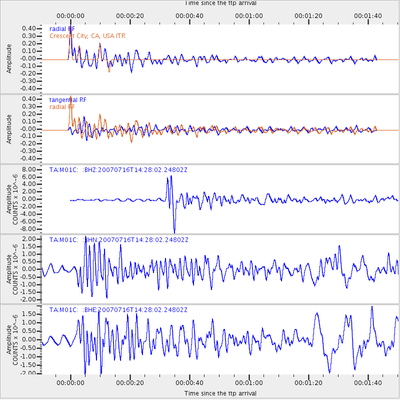
Signal To Noise
| Channel | StoN | STA | LTA |
| TA:M01C: :BHN:20070716T14:28:02.24802Z | 3.8709304 | 6.2751724E-7 | 1.6211018E-7 |
| TA:M01C: :BHE:20070716T14:28:02.24802Z | 3.1132925 | 7.007325E-7 | 2.2507764E-7 |
| TA:M01C: :BHZ:20070716T14:28:02.24802Z | 16.447382 | 2.9726136E-6 | 1.8073476E-7 |
| Arrivals |
| Ps | 2.9 SECOND |
| PpPs | 10 SECOND |
| PsPs/PpSs | 13 SECOND |


