You are here: Home > Network List > TA - USArray Transportable Network (new EarthScope stations) Stations List
> Station M01C Crescent City, CA, USA > Earthquake Result Viewer
M01C Crescent City, CA, USA - Earthquake Result Viewer
| Earthquake location: |
Solomon Islands |
| Earthquake latitude/longitude: |
-8.0/154.6 |
| Earthquake time(UTC): |
2007/06/28 (179) 02:52:09 GMT |
| Earthquake Depth: |
10 km |
| Earthquake Magnitude: |
6.3 MB, 6.7 MS, 6.7 MW, 6.7 MW |
| Earthquake Catalog/Contributor: |
WHDF/NEIC |
|
| Network: |
TA USArray Transportable Network (new EarthScope stations) |
| Station: |
M01C Crescent City, CA, USA |
| Lat/Lon: |
41.85 N/124.12 W |
| Elevation: |
38 m |
|
| Distance: |
88.8 deg |
| Az: |
47.613 deg |
| Baz: |
258.281 deg |
| Ray Param: |
0.04232158 |
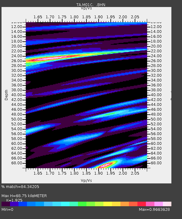
| Estimated Moho Depth: |
68.75 km |
| Estimated Crust Vp/Vs: |
1.92 |
| Assumed Crust Vp: |
6.048 km/s |
| Estimated Crust Vs: |
3.142 km/s |
| Estimated Crust Poisson's Ratio: |
0.32 |
|
| Radial Match: |
84.34205 % |
| Radial Bump: |
283 |
| Transverse Match: |
78.04511 % |
| Transverse Bump: |
360 |
| SOD ConfigId: |
2564 |
| Insert Time: |
2010-03-06 02:49:11.872 +0000 |
| GWidth: |
2.5 |
| Max Bumps: |
400 |
| Tol: |
0.001 |
|
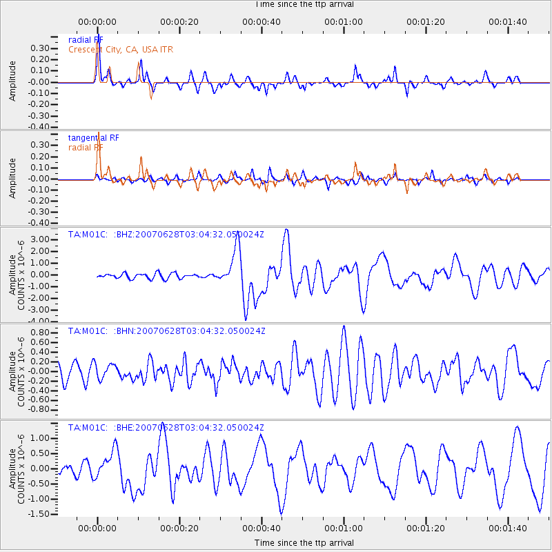
Signal To Noise
| Channel | StoN | STA | LTA |
| TA:M01C: :BHN:20070628T03:04:32.050024Z | 0.8716329 | 1.5971183E-7 | 1.8323291E-7 |
| TA:M01C: :BHE:20070628T03:04:32.050024Z | 2.0980895 | 4.7608128E-7 | 2.2691181E-7 |
| TA:M01C: :BHZ:20070628T03:04:32.050024Z | 7.61559 | 1.6802774E-6 | 2.2063654E-7 |
| Arrivals |
| Ps | 11 SECOND |
| PpPs | 33 SECOND |
| PsPs/PpSs | 43 SECOND |


