You are here: Home > Network List > TA - USArray Transportable Network (new EarthScope stations) Stations List
> Station M01C Crescent City, CA, USA > Earthquake Result Viewer
M01C Crescent City, CA, USA - Earthquake Result Viewer
| Earthquake location: |
Kamchatka Peninsula, Russia |
| Earthquake latitude/longitude: |
52.1/157.3 |
| Earthquake time(UTC): |
2007/05/30 (150) 20:22:12 GMT |
| Earthquake Depth: |
116 km |
| Earthquake Magnitude: |
6.4 MB, 6.4 MW, 6.4 MW |
| Earthquake Catalog/Contributor: |
WHDF/NEIC |
|
| Network: |
TA USArray Transportable Network (new EarthScope stations) |
| Station: |
M01C Crescent City, CA, USA |
| Lat/Lon: |
41.85 N/124.12 W |
| Elevation: |
38 m |
|
| Distance: |
52.1 deg |
| Az: |
68.181 deg |
| Baz: |
310.019 deg |
| Ray Param: |
0.06661714 |
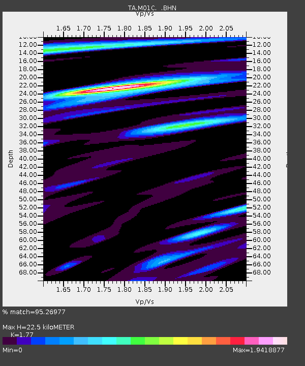
| Estimated Moho Depth: |
22.5 km |
| Estimated Crust Vp/Vs: |
1.77 |
| Assumed Crust Vp: |
6.048 km/s |
| Estimated Crust Vs: |
3.417 km/s |
| Estimated Crust Poisson's Ratio: |
0.27 |
|
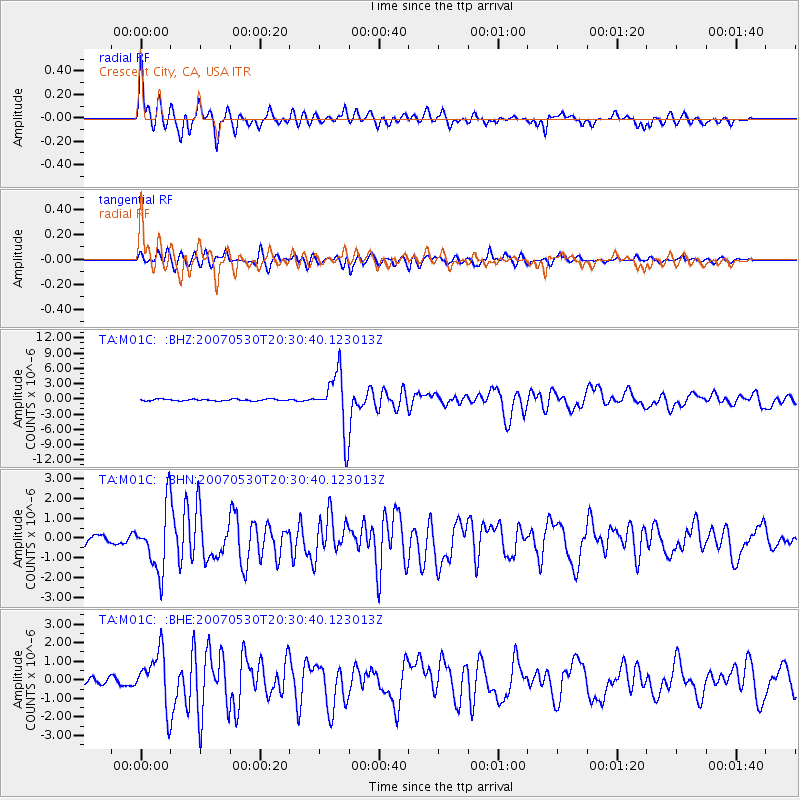
| Radial Match: |
95.26977 % |
| Radial Bump: |
400 |
| Transverse Match: |
89.01106 % |
| Transverse Bump: |
400 |
| SOD ConfigId: |
2564 |
| Insert Time: |
2010-03-06 02:49:13.305 +0000 |
| GWidth: |
2.5 |
| Max Bumps: |
400 |
| Tol: |
0.001 |
|
Signal To Noise
| Channel | StoN | STA | LTA |
| TA:M01C: :BHN:20070530T20:30:40.123013Z | 8.968335 | 1.5825206E-6 | 1.7645644E-7 |
| TA:M01C: :BHE:20070530T20:30:40.123013Z | 10.169304 | 1.4440049E-6 | 1.4199644E-7 |
| TA:M01C: :BHZ:20070530T20:30:40.123013Z | 32.851334 | 5.6925664E-6 | 1.7328267E-7 |
| Arrivals |
| Ps | 3.0 SECOND |
| PpPs | 9.8 SECOND |
| PsPs/PpSs | 13 SECOND |


