You are here: Home > Network List > TA - USArray Transportable Network (new EarthScope stations) Stations List
> Station M01C Crescent City, CA, USA > Earthquake Result Viewer
M01C Crescent City, CA, USA - Earthquake Result Viewer
| Earthquake location: |
Kuril Islands |
| Earthquake latitude/longitude: |
46.5/153.2 |
| Earthquake time(UTC): |
2006/10/01 (274) 09:06:02 GMT |
| Earthquake Depth: |
19 km |
| Earthquake Magnitude: |
6.1 MB, 6.4 MS, 6.6 MW, 6.5 MW |
| Earthquake Catalog/Contributor: |
WHDF/NEIC |
|
| Network: |
TA USArray Transportable Network (new EarthScope stations) |
| Station: |
M01C Crescent City, CA, USA |
| Lat/Lon: |
41.85 N/124.12 W |
| Elevation: |
38 m |
|
| Distance: |
56.9 deg |
| Az: |
62.229 deg |
| Baz: |
305.063 deg |
| Ray Param: |
0.063836575 |
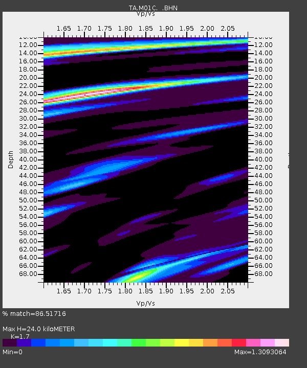
| Estimated Moho Depth: |
24.0 km |
| Estimated Crust Vp/Vs: |
1.70 |
| Assumed Crust Vp: |
6.048 km/s |
| Estimated Crust Vs: |
3.558 km/s |
| Estimated Crust Poisson's Ratio: |
0.24 |
|
| Radial Match: |
86.51716 % |
| Radial Bump: |
400 |
| Transverse Match: |
63.230434 % |
| Transverse Bump: |
400 |
| SOD ConfigId: |
2665 |
| Insert Time: |
2010-03-06 02:49:21.361 +0000 |
| GWidth: |
2.5 |
| Max Bumps: |
400 |
| Tol: |
0.001 |
|
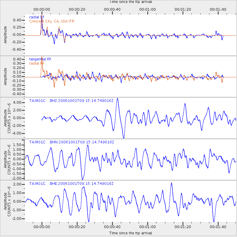
Signal To Noise
| Channel | StoN | STA | LTA |
| TA:M01C: :BHN:20061001T09:15:14.749016Z | 1.9639633 | 5.201703E-7 | 2.6485745E-7 |
| TA:M01C: :BHE:20061001T09:15:14.749016Z | 1.1029726 | 3.6908398E-7 | 3.346266E-7 |
| TA:M01C: :BHZ:20061001T09:15:14.749016Z | 1.6712443 | 6.869044E-7 | 4.1101376E-7 |
| Arrivals |
| Ps | 2.9 SECOND |
| PpPs | 10 SECOND |
| PsPs/PpSs | 13 SECOND |


