You are here: Home > Network List > TA - USArray Transportable Network (new EarthScope stations) Stations List
> Station M01C Crescent City, CA, USA > Earthquake Result Viewer
M01C Crescent City, CA, USA - Earthquake Result Viewer
| Earthquake location: |
Near East Coast Of Kamchatka |
| Earthquake latitude/longitude: |
51.1/157.5 |
| Earthquake time(UTC): |
2006/08/24 (236) 21:50:36 GMT |
| Earthquake Depth: |
43 km |
| Earthquake Magnitude: |
5.9 MB, 6.2 MS, 6.5 MW, 6.5 MW |
| Earthquake Catalog/Contributor: |
WHDF/NEIC |
|
| Network: |
TA USArray Transportable Network (new EarthScope stations) |
| Station: |
M01C Crescent City, CA, USA |
| Lat/Lon: |
41.85 N/124.12 W |
| Elevation: |
38 m |
|
| Distance: |
52.3 deg |
| Az: |
67.606 deg |
| Baz: |
308.79 deg |
| Ray Param: |
0.06673785 |
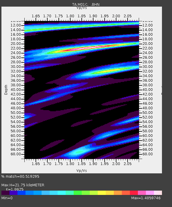
| Estimated Moho Depth: |
21.75 km |
| Estimated Crust Vp/Vs: |
1.86 |
| Assumed Crust Vp: |
6.048 km/s |
| Estimated Crust Vs: |
3.247 km/s |
| Estimated Crust Poisson's Ratio: |
0.30 |
|
| Radial Match: |
80.519295 % |
| Radial Bump: |
400 |
| Transverse Match: |
69.54947 % |
| Transverse Bump: |
400 |
| SOD ConfigId: |
2665 |
| Insert Time: |
2010-03-06 02:49:23.706 +0000 |
| GWidth: |
2.5 |
| Max Bumps: |
400 |
| Tol: |
0.001 |
|
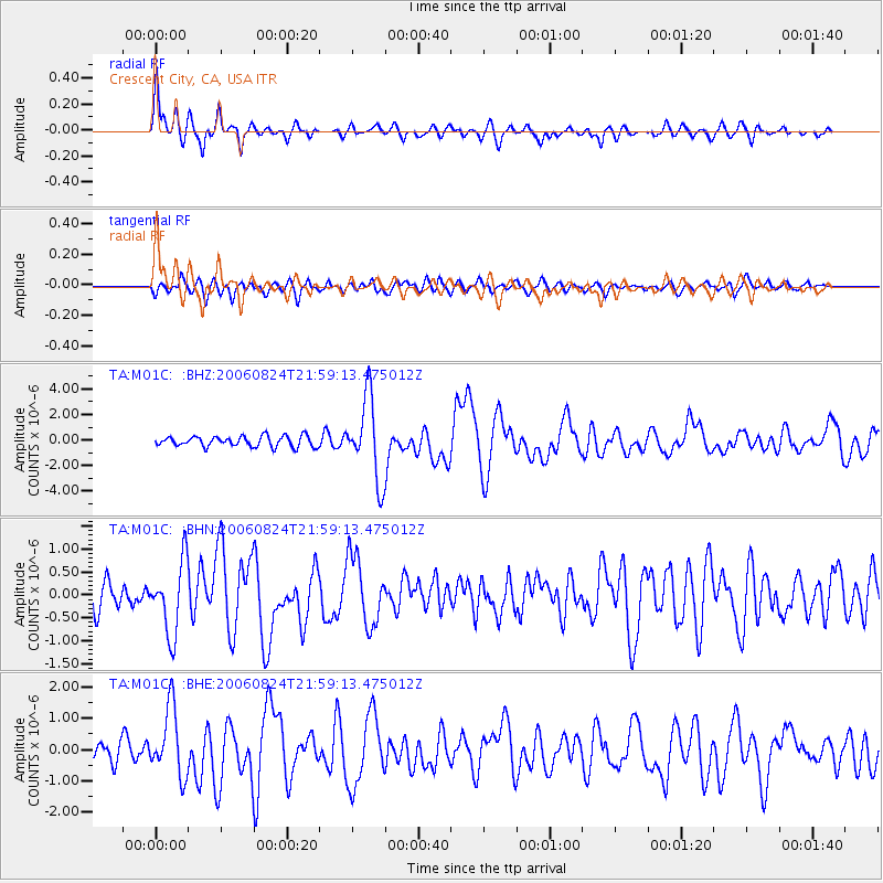
Signal To Noise
| Channel | StoN | STA | LTA |
| TA:M01C: :BHN:20060824T21:59:13.475012Z | 2.0061963 | 7.84112E-7 | 3.908451E-7 |
| TA:M01C: :BHE:20060824T21:59:13.475012Z | 4.026684 | 1.0944264E-6 | 2.7179345E-7 |
| TA:M01C: :BHZ:20060824T21:59:13.475012Z | 7.820759 | 3.1948696E-6 | 4.0851145E-7 |
| Arrivals |
| Ps | 3.2 SECOND |
| PpPs | 9.8 SECOND |
| PsPs/PpSs | 13 SECOND |


