You are here: Home > Network List > TA - USArray Transportable Network (new EarthScope stations) Stations List
> Station SUTB Sutter Butte, CA, USA > Earthquake Result Viewer
SUTB Sutter Butte, CA, USA - Earthquake Result Viewer
| Earthquake location: |
Vanuatu Islands |
| Earthquake latitude/longitude: |
-15.6/167.7 |
| Earthquake time(UTC): |
2007/08/01 (213) 17:08:51 GMT |
| Earthquake Depth: |
120 km |
| Earthquake Magnitude: |
6.2 MB, 7.2 MW, 7.2 MW |
| Earthquake Catalog/Contributor: |
WHDF/NEIC |
|
| Network: |
TA USArray Transportable Network (new EarthScope stations) |
| Station: |
SUTB Sutter Butte, CA, USA |
| Lat/Lon: |
39.23 N/121.79 W |
| Elevation: |
252 m |
|
| Distance: |
85.3 deg |
| Az: |
47.284 deg |
| Baz: |
245.724 deg |
| Ray Param: |
0.04456755 |
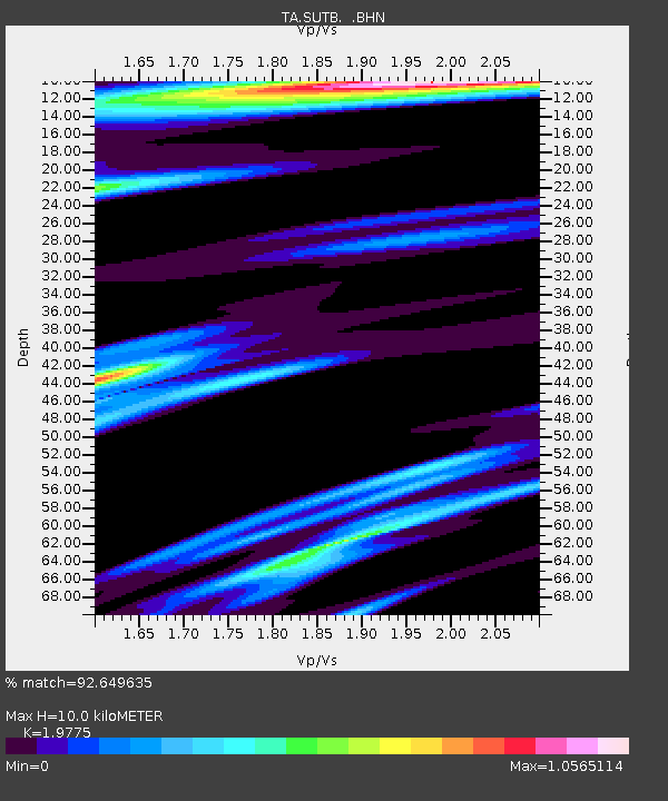
| Estimated Moho Depth: |
10.0 km |
| Estimated Crust Vp/Vs: |
1.98 |
| Assumed Crust Vp: |
6.597 km/s |
| Estimated Crust Vs: |
3.336 km/s |
| Estimated Crust Poisson's Ratio: |
0.33 |
|
| Radial Match: |
92.649635 % |
| Radial Bump: |
400 |
| Transverse Match: |
80.62105 % |
| Transverse Bump: |
400 |
| SOD ConfigId: |
2564 |
| Insert Time: |
2010-03-06 02:49:32.162 +0000 |
| GWidth: |
2.5 |
| Max Bumps: |
400 |
| Tol: |
0.001 |
|

Signal To Noise
| Channel | StoN | STA | LTA |
| TA:SUTB: :BHN:20070801T17:20:43.944006Z | 0.975899 | 3.061822E-7 | 3.1374373E-7 |
| TA:SUTB: :BHE:20070801T17:20:43.944006Z | 2.3602593 | 5.688782E-7 | 2.410236E-7 |
| TA:SUTB: :BHZ:20070801T17:20:43.944006Z | 8.7588005 | 1.5015568E-6 | 1.7143405E-7 |
| Arrivals |
| Ps | 1.5 SECOND |
| PpPs | 4.4 SECOND |
| PsPs/PpSs | 5.9 SECOND |


