
Station TA SUTB - Sutter Butte, CA, USA
Network: TA - USArray Transportable Network (new EarthScope stations)
Nearby stations (2 deg radius)
| Station | Name | (Lat, Lon) | Start / End | Elevation |
| SUTB | Sutter Butte, CA, USA | (39.23, -121.79) | 2005-05-17 / 2499-01-01 | 252 m |
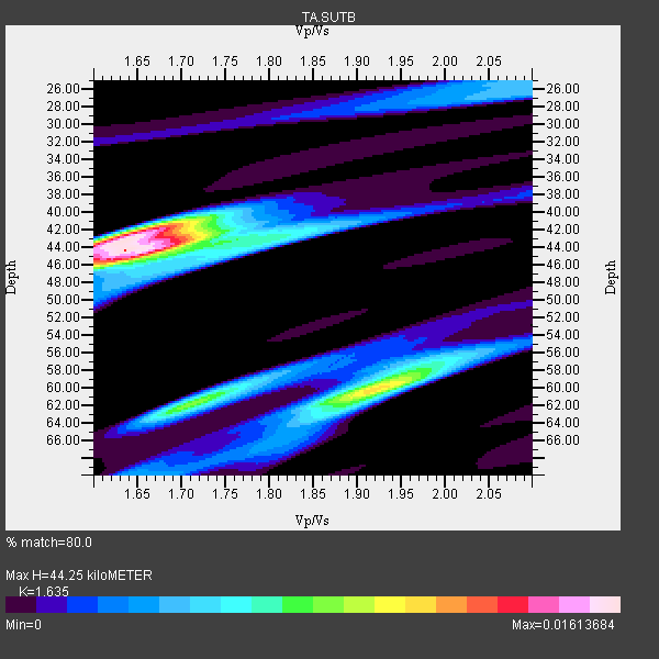
| Crust2 Type: | L3,continental arc, Southern Andes, 0.2 km seds. |
| Thickness Estimate: | 44 km |
| Thickness StdDev: | 6.0 km |
| Vp/Vs Estimate: | 1.63 |
| Vp/Vs StdDev: | 0.10 |
| Vs Estimate: | 4.035 km/s |
| Poisson's Ratio: | 0.20 |
| Peak Value: | 0.02 |
| Assumed Vp: | 6.597 km/s |
| Ps Weight: | 0.33333334 |
| PpPs Weight: | 0.33333334 |
| PsPs Weight: | 0.33333328 |
| Residual Complexity: | 0.719 |
| Nearby stations H: | +- |
| (2.0 deg) Vp/Vs: | +- |
14 with match > 90% ( 43.75 %) and 32 with match > 80% ( 100.0 %) out of 32.
Download stack as xyz text file.
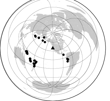
Azimuth Distribution of Events:
Prior Results for this Station
| Study | Thickness | Vp/Vs | Vp | Vs | Poissons Ratio | Extra |
| EARS | 44 km | 1.63 | 6.597 km/s | 4.035 km/s | 0.20 | |
| Crust2.0 | 40 km | 1.77 | 6.597 km/s | 3.723 km/s | 0.27 | L3,continental arc, Southern Andes, 0.2 km seds. |
| Global Maxima | 44 km | 1.63 | 6.597 km/s | 4.035 km/s | 0.20 | amp=0.01613684 |
| Local Maxima 1 | 42 km | 1.65 | 6.597 km/s | 3.998 km/s | 0.21 | amp=0.012530003 |
| Local Maxima 2 | 60 km | 1.91 | 6.597 km/s | 3.45 km/s | 0.31 | amp=0.011150598 |
| Local Maxima 3 | 62 km | 1.71 | 6.597 km/s | 3.858 km/s | 0.24 | amp=0.008551405 |
| Local Maxima 4 | 44 km | 1.78 | 6.597 km/s | 3.701 km/s | 0.27 | amp=0.0063650943 |
| Predicted Arrivals for vertical incidence (zero ray parameter) | |
| Ps | 4.26 SECOND |
| PpPs | 17.67 SECOND |
| PsPs/PpSs | 21.93 SECOND |
Events Processed for this Station
Download zip of receiver functions as SAC
Plot maxima for each earthquake.
Events Used in the Stack
(32 events)| Radial Match | Distance | Baz | FERegion | Time | Lat/Lon | Depth | Magnitude |
| 98.57948 | 76.7 deg | 229.819 deg | Tonga Islands | 2006/05/03 15:26:40 GMT | (-20.2, -174.1) | 55 km | 7.2 MB, 7.8 MS, 7.9 MW, 7.9 MW |
| 97.48348 | 88.5 deg | 257.922 deg | Solomon Islands | 2007/04/01 20:39:56 GMT | (-8.5, 157.0) | 10 km | 6.8 MB, 7.9 MS, 8.1 MW, 7.7 ME |
| 96.4502 | 47.7 deg | 321.396 deg | Eastern Siberia, Russia | 2006/04/20 23:25:02 GMT | (60.9, 167.1) | 22 km | 6.8 MB, 7.6 MS, 7.6 MW, 7.3 MW |
| 94.771255 | 61.3 deg | 126.098 deg | Northern Peru | 2005/09/26 01:55:37 GMT | (-5.7, -76.4) | 115 km | 6.7 MB, 7.5 MW, 7.5 MW |
| 93.85468 | 73.9 deg | 305.371 deg | Near West Coast Of Honshu, Japan | 2007/07/16 01:13:22 GMT | (37.5, 138.4) | 12 km | 6.5 MB, 6.4 MS, 6.6 MW, 6.5 MW |
| 93.71257 | 34.2 deg | 308.232 deg | Fox Islands, Aleutian Islands | 2007/07/15 13:08:00 GMT | (52.5, -168.0) | 10 km | 5.8 MB, 5.9 MS, 6.1 MW, 6.0 MW |
| 93.54306 | 67.2 deg | 131.607 deg | Near Coast Of Peru | 2006/10/20 10:48:56 GMT | (-13.5, -76.7) | 23 km | 5.9 MB, 6.6 MS, 6.7 MW, 6.6 MW |
| 93.17565 | 72.7 deg | 230.548 deg | Samoa Islands Region | 2006/09/28 06:22:09 GMT | (-16.6, -172.0) | 28 km | 6.5 MB, 6.6 MS, 6.9 MW, 6.7 MW |
| 93.16806 | 59.9 deg | 307.23 deg | Kuril Islands | 2006/10/01 09:06:02 GMT | (46.5, 153.2) | 19 km | 6.1 MB, 6.4 MS, 6.6 MW, 6.5 MW |
| 92.94843 | 88.6 deg | 225.949 deg | Kermadec Islands Region | 2006/05/16 10:39:23 GMT | (-31.8, -179.3) | 152 km | 6.8 MB, 7.4 MW, 7.4 MW |
| 92.649635 | 85.3 deg | 245.724 deg | Vanuatu Islands | 2007/08/01 17:08:51 GMT | (-15.6, 167.7) | 120 km | 6.2 MB, 7.2 MW, 7.2 MW |
| 92.44498 | 90.0 deg | 259.823 deg | Solomon Islands | 2007/06/28 02:52:09 GMT | (-8.0, 154.6) | 10 km | 6.3 MB, 6.7 MS, 6.7 MW, 6.7 MW |
| 91.21154 | 75.8 deg | 236.413 deg | Fiji Islands Region | 2005/12/13 03:16:06 GMT | (-15.3, -178.6) | 10 km | 6.1 MB, 6.8 MS, 6.7 MW, 6.7 MW |
| 91.14 | 83.5 deg | 228.468 deg | South Of Fiji Islands | 2007/07/18 00:07:35 GMT | (-26.3, -177.7) | 10 km | 5.8 MB, 5.9 MS, 6.1 MW, 6.0 MW |
| 89.613205 | 88.8 deg | 263.186 deg | New Ireland Region, P.N.G. | 2005/09/09 07:26:43 GMT | (-4.5, 153.5) | 90 km | 6.3 MB, 7.7 MW, 7.5 MW |
| 88.20864 | 85.4 deg | 245.512 deg | Vanuatu Islands | 2006/08/07 22:18:54 GMT | (-15.8, 167.8) | 141 km | 6.0 MB, 6.8 MW, 6.8 MW |
| 88.04166 | 91.5 deg | 263.722 deg | New Britain Region, P.N.G. | 2006/10/17 01:25:12 GMT | (-5.9, 151.0) | 32 km | 6.4 MB, 6.9 MS, 6.7 MW, 6.6 MW |
| 87.285446 | 84.6 deg | 245.275 deg | Vanuatu Islands | 2007/07/15 09:27:34 GMT | (-15.4, 168.6) | 8.0 km | 6.0 MB, 5.8 MS, 6.1 MW, 6.0 MW |
| 86.111984 | 59.3 deg | 306.493 deg | East Of Kuril Islands | 2006/12/07 19:10:21 GMT | (46.2, 154.4) | 16 km | 6.3 MB, 6.1 MS, 6.3 MW, 6.3 MW |
| 85.92313 | 82.8 deg | 231.79 deg | South Of Fiji Islands | 2006/02/26 03:08:27 GMT | (-23.6, -180.0) | 535 km | 5.9 MB, 6.4 MW, 6.4 MW |
| 85.881836 | 47.6 deg | 320.745 deg | Eastern Siberia, Russia | 2006/04/29 16:58:06 GMT | (60.5, 167.5) | 11 km | 6.4 MB, 6.6 MS, 6.6 MW, 6.4 MW |
| 84.24634 | 87.6 deg | 240.979 deg | Vanuatu Islands | 2007/03/25 00:40:01 GMT | (-20.6, 169.4) | 34 km | 6.5 MB, 7.0 MS, 7.1 MW, 7.1 MW |
| 84.115715 | 43.4 deg | 307.609 deg | Rat Islands, Aleutian Islands | 2006/06/14 04:18:42 GMT | (51.8, 177.1) | 14 km | 5.9 MB, 6.4 MS, 6.4 MW, 6.4 MW |
| 83.98299 | 42.6 deg | 120.951 deg | Nicaragua | 2005/08/03 11:03:15 GMT | (11.2, -85.5) | 14 km | 6.0 MB, 6.5 MS, 6.3 MW, 6.3 MW |
| 83.81682 | 88.6 deg | 260.193 deg | Solomon Islands | 2006/09/01 10:18:51 GMT | (-6.8, 155.5) | 38 km | 6.3 MB, 6.7 MS, 6.8 MW, 6.7 MW |
| 83.73454 | 87.1 deg | 239.349 deg | Southeast Of Loyalty Islands | 2007/07/27 14:46:26 GMT | (-21.5, 170.9) | 10 km | 6.0 MB, 6.0 MS, 6.1 MW, 6.1 MW |
| 83.663635 | 74.3 deg | 236.021 deg | Fiji Islands Region | 2005/08/07 11:35:26 GMT | (-14.4, -177.3) | 10 km | 5.7 MB, 5.9 MS, 6.0 MW, 6.0 MW |
| 83.647064 | 87.1 deg | 225.956 deg | Kermadec Islands, New Zealand | 2007/05/17 19:29:10 GMT | (-30.7, -178.2) | 41 km | 5.5 MB, 5.6 MS, 6.0 MW, 5.9 MW |
| 83.29939 | 71.2 deg | 304.033 deg | Near East Coast Of Honshu, Japan | 2005/12/02 13:13:09 GMT | (38.1, 142.1) | 29 km | 6.1 MB, 6.3 MS, 6.5 MW, 6.4 MW |
| 83.1392 | 86.6 deg | 242.473 deg | Vanuatu Islands | 2006/10/03 18:03:14 GMT | (-18.9, 169.0) | 171 km | 5.9 MB, 6.3 MW, 6.3 MW |
| 82.41278 | 83.5 deg | 228.53 deg | South Of Fiji Islands | 2007/07/17 09:39:27 GMT | (-26.2, -177.7) | 10 km | 5.7 MB, 6.0 MS, 6.1 MW, 6.0 MW |
| 80.122536 | 64.3 deg | 125.945 deg | Peru-Brazil Border Region | 2007/07/12 05:23:49 GMT | (-7.9, -74.4) | 152 km | 5.9 MB, 6.1 MW, 6.0 MW |
Losers
(0 events)| Radial Match | Distance | Baz | FERegion | Time | Lat/Lon | Depth | Magnitude | Reason |
