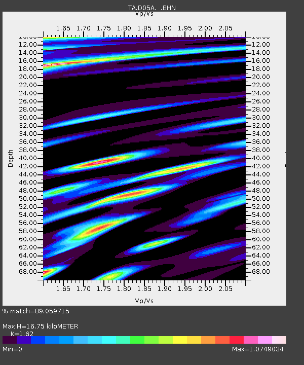
D05A Enumclaw, WA, USA - Earthquake Result Viewer

Earthquake location: Andreanof Islands, Aleutian Is.
Earthquake latitude/longitude: 51.4/-179.5
Earthquake time(UTC): 2007/12/19 (353) 09:30:27 GMT
Earthquake Depth: 29 km
Earthquake Magnitude: 6.4 MB, 7.1 MS, 7.1 MW, 7.0 MW
Earthquake Catalog/Contributor: WHDF/NEIC
Network: TA USArray Transportable Network (new EarthScope stations)
Station: D05A Enumclaw, WA, USA
Lat/Lon: 47.19 N/121.99 W
Elevation: 266 m
Distance: 36.9 deg
Az: 73.245 deg
Baz: 298.336 deg
Ray Param: 0.07635703
Estimated Moho Depth: 16.75 km
Estimated Crust Vp/Vs: 1.62
Assumed Crust Vp: 6.597 km/s
Estimated Crust Vs: 4.073 km/s
Estimated Crust Poisson's Ratio: 0.19
Radial Match: 89.059715 %
Radial Bump: 400
Transverse Match: 78.28182 %
Transverse Bump: 400
SOD ConfigId: 2564
Insert Time: 2010-03-06 02:58:56.664 +0000
GWidth: 2.5
Max Bumps: 400
Tol: 0.001

Signal To Noise

ChannelStoNSTALTA
TA:D05A: :BHN:20071219T09:37:03.098013Z2.2391313.2320504E-61.4434395E-6
TA:D05A: :BHE:20071219T09:37:03.098013Z2.28837232.426645E-61.0604241E-6
TA:D05A: :BHZ:20071219T09:37:03.098013Z7.30761245.285561E-67.232952E-7
Arrivals
Ps1.7 SECOND
PpPs6.1 SECOND
PsPs/PpSs7.8 SECOND