
Station TA D05A - Enumclaw, WA, USA
Network: TA - USArray Transportable Network (new EarthScope stations)
Nearby stations (2 deg radius)
| Station | Name | (Lat, Lon) | Start / End | Elevation |
| D05A | Enumclaw, WA, USA | (47.19, -121.99) | 2005-11-21 / 2499-01-01 | 0.3 km |
| Crust2 Type: | L3,continental arc, Southern Andes, 0.2 km seds. |
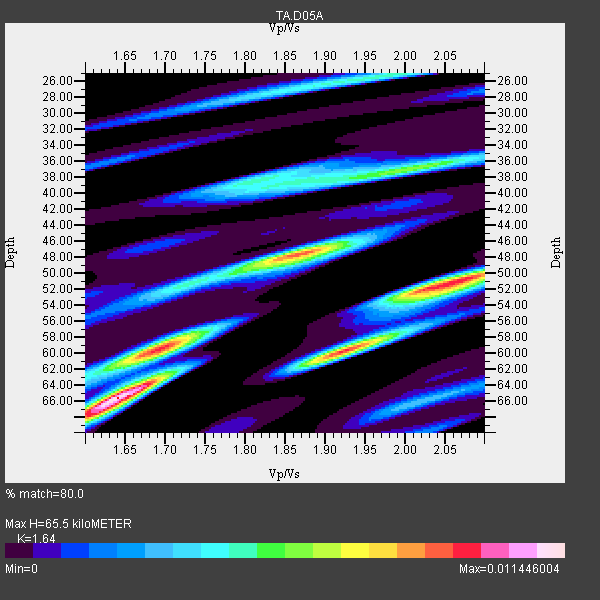
| Thickness Estimate: | 66 km |
| Thickness StdDev: | 9.3 km |
| Vp/Vs Estimate: | 1.64 |
| Vp/Vs StdDev: | 0.16 |
| Vs Estimate: | 4.023 km/s |
| Poisson's Ratio: | 0.20 |
| Peak Value: | 0.01 |
| Assumed Vp: | 6.597 km/s |
| Ps Weight: | 0.33333334 |
| PpPs Weight: | 0.33333334 |
| PsPs Weight: | 0.33333328 |
| Residual Complexity: | 0.833 |
| Nearby stations H: | 50 km +- 22 km |
| (2.0 deg) Vp/Vs: | 1.87 +- 0.32 |
5 with match > 90% ( 15.625 %) and 31 with match > 80% ( 96.875 %) out of 32.
Download stack as xyz text file.
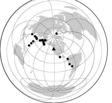
Azimuth Distribution of Events:
Prior Results for this Station
| Study | Thickness | Vp/Vs | Vp | Vs | Poissons Ratio | Extra |
| EARS | 66 km | 1.64 | 6.597 km/s | 4.023 km/s | 0.20 | |
| Crust2.0 | 40 km | 1.77 | 6.597 km/s | 3.723 km/s | 0.27 | L3,continental arc, Southern Andes, 0.2 km seds. |
| Global Maxima | 66 km | 1.64 | 6.597 km/s | 4.023 km/s | 0.20 | amp=0.011446004 |
| Local Maxima 1 | 51 km | 2.05 | 6.597 km/s | 3.214 km/s | 0.34 | amp=0.009562592 |
| Local Maxima 2 | 48 km | 1.87 | 6.597 km/s | 3.528 km/s | 0.30 | amp=0.008633986 |
| Local Maxima 3 | 60 km | 1.68 | 6.597 km/s | 3.921 km/s | 0.23 | amp=0.00624677 |
| Local Maxima 4 | 37 km | 2.00 | 6.597 km/s | 3.303 km/s | 0.33 | amp=0.0062253163 |
| Predicted Arrivals for vertical incidence (zero ray parameter) | |
| Ps | 6.35 SECOND |
| PpPs | 26.21 SECOND |
| PsPs/PpSs | 32.56 SECOND |
Events Processed for this Station
Download zip of receiver functions as SAC
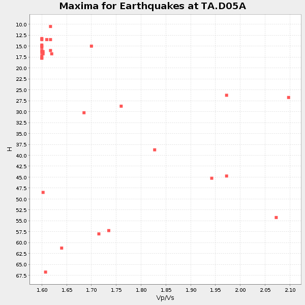
Plot maxima for each earthquake.
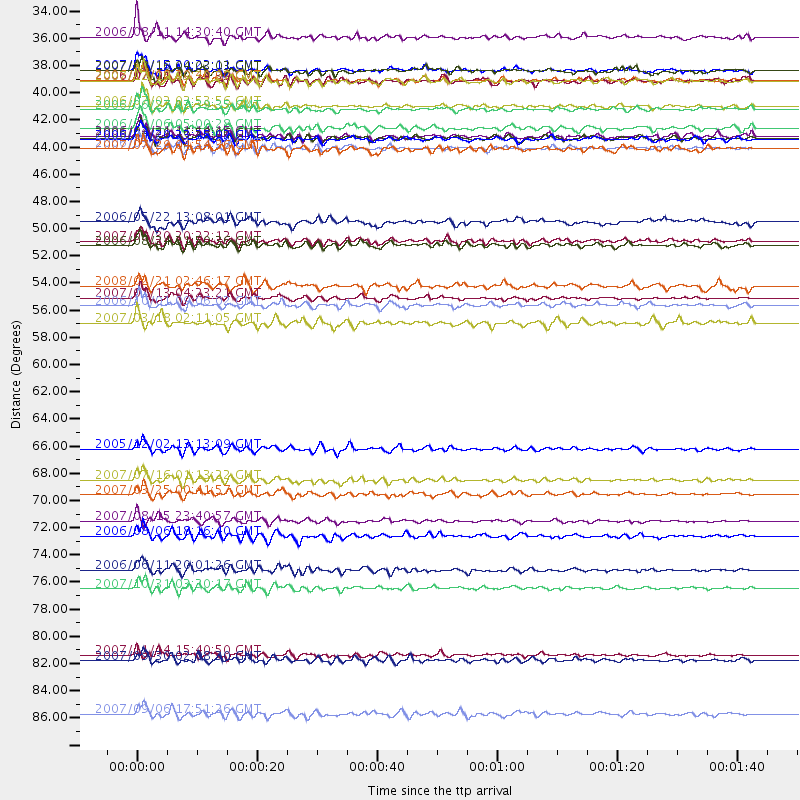
Events Used in the Stack
(31 events)| Radial Match | Distance | Baz | FERegion | Time | Lat/Lon | Depth | Magnitude |
| 94.16298 | 41.7 deg | 316.057 deg | Eastern Siberia, Russia | 2006/04/20 23:25:02 GMT | (60.9, 167.1) | 22 km | 6.8 MB, 7.6 MS, 7.6 MW, 7.3 MW |
| 94.05866 | 54.5 deg | 302.155 deg | East Of Kuril Islands | 2007/01/13 04:23:21 GMT | (46.2, 154.5) | 10 km | 7.3 MB, 8.2 MS, 8.1 MW, 7.9 MW |
| 91.12294 | 36.9 deg | 298.034 deg | Andreanof Islands, Aleutian Is. | 2006/07/08 20:40:00 GMT | (51.2, -179.3) | 22 km | 6.2 MB, 6.4 MS, 6.6 MW, 6.6 MW |
| 90.20734 | 41.6 deg | 315.309 deg | Eastern Siberia, Russia | 2006/04/29 16:58:06 GMT | (60.5, 167.5) | 11 km | 6.4 MB, 6.6 MS, 6.6 MW, 6.4 MW |
| 90.17615 | 36.0 deg | 296.047 deg | Andreanof Islands, Aleutian Is. | 2007/08/15 20:22:11 GMT | (50.3, -177.5) | 9.0 km | 6.3 MB, 6.2 MS, 6.4 MW, 5.9 ML |
| 89.11971 | 73.9 deg | 291.016 deg | Bonin Islands, Japan Region | 2006/08/06 18:16:40 GMT | (26.1, 144.0) | 23 km | 6.0 MB, 5.6 MS, 5.8 MW, 5.8 MW |
| 89.059715 | 36.9 deg | 298.336 deg | Andreanof Islands, Aleutian Is. | 2007/12/19 09:30:27 GMT | (51.4, -179.5) | 29 km | 6.4 MB, 7.1 MS, 7.1 MW, 7.0 MW |
| 87.23193 | 50.3 deg | 306.139 deg | Near East Coast Of Kamchatka | 2006/08/24 21:50:36 GMT | (51.1, 157.5) | 43 km | 5.9 MB, 6.2 MS, 6.5 MW, 6.5 MW |
| 87.09284 | 83.5 deg | 132.631 deg | Northern Chile | 2007/11/14 15:40:50 GMT | (-22.2, -69.9) | 40 km | 6.7 MB, 7.4 MS, 7.7 MW, 7.4 ME |
| 86.922325 | 70.5 deg | 304.019 deg | Near West Coast Of Honshu, Japan | 2007/03/25 00:41:57 GMT | (37.3, 136.6) | 8.0 km | 6.1 MB, 6.8 MS, 6.7 MW, 6.6 MW |
| 86.726715 | 42.3 deg | 316.05 deg | Eastern Siberia, Russia | 2006/05/22 11:12:00 GMT | (60.8, 165.7) | 16 km | 6.0 MB, 6.7 MS, 6.6 MW, 6.5 MW |
| 86.6611 | 55.1 deg | 302.993 deg | Kuril Islands | 2006/10/01 09:06:02 GMT | (46.5, 153.2) | 19 km | 6.1 MB, 6.4 MS, 6.6 MW, 6.5 MW |
| 85.89677 | 66.8 deg | 301.352 deg | Near East Coast Of Honshu, Japan | 2005/12/02 13:13:09 GMT | (38.1, 142.1) | 29 km | 6.1 MB, 6.3 MS, 6.5 MW, 6.4 MW |
| 85.539696 | 78.1 deg | 284.894 deg | Mariana Islands | 2007/10/31 03:30:17 GMT | (18.9, 145.4) | 223 km | 6.2 MB, 7.2 MW, 7.2 MW |
| 85.533646 | 33.3 deg | 141.902 deg | Guerrero, Mexico | 2006/08/11 14:30:40 GMT | (18.6, -101.1) | 60 km | 6.0 MB, 6.1 MW, 6.0 MW |
| 85.26521 | 39.2 deg | 300.934 deg | Rat Islands, Aleutian Islands | 2006/06/27 02:39:35 GMT | (52.2, 176.2) | 34 km | 5.6 MB, 6.0 MS, 6.2 MW, 6.2 MW |
| 84.761856 | 76.6 deg | 304.364 deg | Kyushu, Japan | 2006/06/11 20:01:26 GMT | (33.1, 131.1) | 140 km | 5.9 MB, 6.3 MW, 6.3 MW |
| 83.90626 | 72.7 deg | 133.471 deg | Near Coast Of Peru | 2007/08/15 23:40:57 GMT | (-13.4, -76.6) | 39 km | 6.7 MB, 7.9 MS, 8.0 MW, 7.5 ME |
| 83.53548 | 40.8 deg | 316.808 deg | Eastern Siberia, Russia | 2006/09/06 05:00:28 GMT | (61.6, 168.6) | 10 km | 5.5 MB, 5.0 MS, 5.4 MW, 5.3 MW |
| 83.236374 | 38.9 deg | 299.963 deg | Rat Islands, Aleutian Islands | 2006/07/02 03:53:56 GMT | (51.7, 176.9) | 8.6 km | 5.5 MB, 5.3 MS, 5.8 MW, 5.7 MW |
| 82.94864 | 36.1 deg | 295.925 deg | Andreanof Islands, Aleutian Is. | 2007/08/16 04:03:03 GMT | (50.2, -177.6) | 15 km | 5.8 MB |
| 82.397934 | 42.5 deg | 304.974 deg | Komandorskiye Ostrova Region | 2007/07/29 04:54:36 GMT | (53.6, 169.7) | 26 km | 6.0 MB, 5.5 MS, 5.9 MW, 5.8 MW |
| 82.347824 | 84.0 deg | 278.776 deg | South Of Mariana Islands | 2007/09/30 02:08:30 GMT | (10.5, 145.7) | 14 km | 6.4 MB, 7.1 MS, 6.9 MW, 6.9 MW |
| 82.24811 | 53.6 deg | 10.235 deg | Svalbard Region | 2008/02/21 02:46:17 GMT | (77.1, 18.6) | 10 km | 5.7 MB, 5.9 MS, 6.1 MW, 6.0 MW |
| 81.78618 | 56.5 deg | 124.685 deg | South Of Panama | 2007/03/18 02:11:05 GMT | (4.6, -78.5) | 8.0 km | 6.4 MB, 5.7 MS, 6.2 MW, 6.1 MW |
| 81.7048 | 36.9 deg | 297.794 deg | Andreanof Islands, Aleutian Is. | 2006/07/01 19:34:39 GMT | (51.1, -179.3) | 42 km | 5.2 MB, 5.1 MS, 5.5 MW, 5.3 MW |
| 81.34449 | 48.3 deg | 309.468 deg | Kamchatka Peninsula, Russia | 2006/05/22 13:08:01 GMT | (54.3, 158.4) | 185 km | 6.2 MB, 6.2 MW, 6.2 MW |
| 81.17516 | 41.4 deg | 316.577 deg | Eastern Siberia, Russia | 2006/04/21 11:14:15 GMT | (61.4, 167.5) | 12 km | 5.8 MB, 5.8 MS, 6.1 MW, 6.1 MW |
| 80.97757 | 69.3 deg | 303.067 deg | Near West Coast Of Honshu, Japan | 2007/07/16 01:13:22 GMT | (37.5, 138.4) | 12 km | 6.5 MB, 6.4 MS, 6.6 MW, 6.5 MW |
| 80.66487 | 49.9 deg | 307.361 deg | Kamchatka Peninsula, Russia | 2007/05/30 20:22:12 GMT | (52.1, 157.3) | 116 km | 6.4 MB, 6.4 MW, 6.4 MW |
| 80.164246 | 88.3 deg | 304.752 deg | Taiwan Region | 2007/09/06 17:51:26 GMT | (24.3, 122.2) | 53 km | 6.1 MB, 6.2 MW, 6.1 ME |
Losers
(1 events)| Radial Match | Distance | Baz | FERegion | Time | Lat/Lon | Depth | Magnitude | Reason |
| 94.73904 | 90.1 deg | 257.686 deg | Solomon Islands | 2007/04/01 20:39:56 GMT | (-8.5, 157.0) | 10 km | 6.8 MB, 7.9 MS, 8.1 MW, 7.7 ME |
