D05A Enumclaw, WA, USA - Earthquake Result Viewer
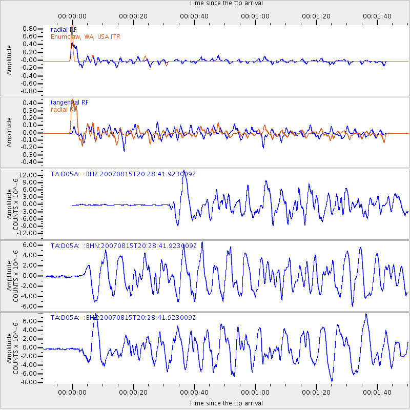
Earthquake location: Andreanof Islands, Aleutian Is.
Earthquake latitude/longitude: 50.3/-177.5
Earthquake time(UTC): 2007/08/15 (227) 20:22:11 GMT
Earthquake Depth: 9.0 km
Earthquake Magnitude: 6.3 MB, 6.2 MS, 6.4 MW, 5.9 ML
Earthquake Catalog/Contributor: WHDF/NEIC
Network: TA USArray Transportable Network (new EarthScope stations)
Station: D05A Enumclaw, WA, USA
Lat/Lon: 47.19 N/121.99 W
Elevation: 266 m
Distance: 36.0 deg
Az: 72.931 deg
Baz: 296.047 deg
Ray Param: 0.07689756
Estimated Moho Depth: 13.5 km
Estimated Crust Vp/Vs: 1.61
Assumed Crust Vp: 6.597 km/s
Estimated Crust Vs: 4.098 km/s
Estimated Crust Poisson's Ratio: 0.19
Radial Match: 90.17615 %
Radial Bump: 400
Transverse Match: 75.057014 %
Transverse Bump: 400
SOD ConfigId: 2564
Insert Time: 2010-03-06 02:59:11.779 +0000
GWidth: 2.5
Max Bumps: 400
Tol: 0.001

Signal To Noise

ChannelStoNSTALTA
TA:D05A: :BHN:20070815T20:28:41.923009Z6.15836865.4737484E-78.88831E-8
TA:D05A: :BHE:20070815T20:28:41.923009Z9.7602888.225627E-78.427647E-8
TA:D05A: :BHZ:20070815T20:28:41.923009Z30.4845523.1886032E-61.0459734E-7
Arrivals
Ps1.4 SECOND
PpPs4.9 SECOND
PsPs/PpSs6.3 SECOND