You are here: Home > Network List > TA - USArray Transportable Network (new EarthScope stations) Stations List
> Station D05A Enumclaw, WA, USA > Earthquake Result Viewer
D05A Enumclaw, WA, USA - Earthquake Result Viewer
| Earthquake location: |
Komandorskiye Ostrova Region |
| Earthquake latitude/longitude: |
53.6/169.7 |
| Earthquake time(UTC): |
2007/07/29 (210) 04:54:36 GMT |
| Earthquake Depth: |
26 km |
| Earthquake Magnitude: |
6.0 MB, 5.5 MS, 5.9 MW, 5.8 MW |
| Earthquake Catalog/Contributor: |
WHDF/NEIC |
|
| Network: |
TA USArray Transportable Network (new EarthScope stations) |
| Station: |
D05A Enumclaw, WA, USA |
| Lat/Lon: |
47.19 N/121.99 W |
| Elevation: |
266 m |
|
| Distance: |
42.5 deg |
| Az: |
69.821 deg |
| Baz: |
304.974 deg |
| Ray Param: |
0.07311626 |
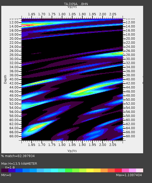
| Estimated Moho Depth: |
13.5 km |
| Estimated Crust Vp/Vs: |
1.60 |
| Assumed Crust Vp: |
6.597 km/s |
| Estimated Crust Vs: |
4.123 km/s |
| Estimated Crust Poisson's Ratio: |
0.18 |
|
| Radial Match: |
82.397934 % |
| Radial Bump: |
400 |
| Transverse Match: |
77.766624 % |
| Transverse Bump: |
400 |
| SOD ConfigId: |
2564 |
| Insert Time: |
2010-03-06 02:59:14.157 +0000 |
| GWidth: |
2.5 |
| Max Bumps: |
400 |
| Tol: |
0.001 |
|

Signal To Noise
| Channel | StoN | STA | LTA |
| TA:D05A: :BHN:20070729T05:01:58.850015Z | 0.62399614 | 1.07282204E-7 | 1.7192767E-7 |
| TA:D05A: :BHE:20070729T05:01:58.850015Z | 1.4400277 | 2.0212973E-7 | 1.4036516E-7 |
| TA:D05A: :BHZ:20070729T05:01:58.850015Z | 2.2519164 | 3.3573366E-7 | 1.4908798E-7 |
| Arrivals |
| Ps | 1.3 SECOND |
| PpPs | 4.9 SECOND |
| PsPs/PpSs | 6.2 SECOND |


