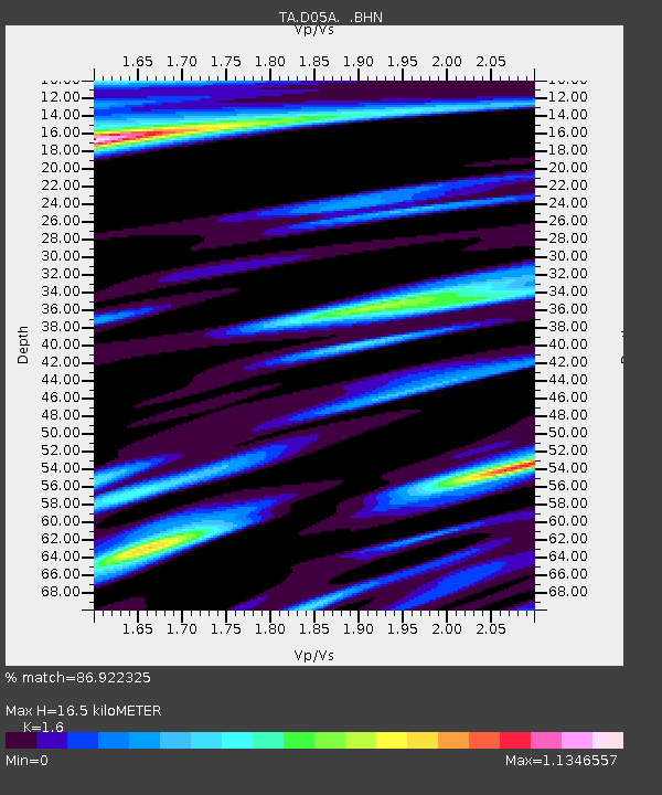
D05A Enumclaw, WA, USA - Earthquake Result Viewer
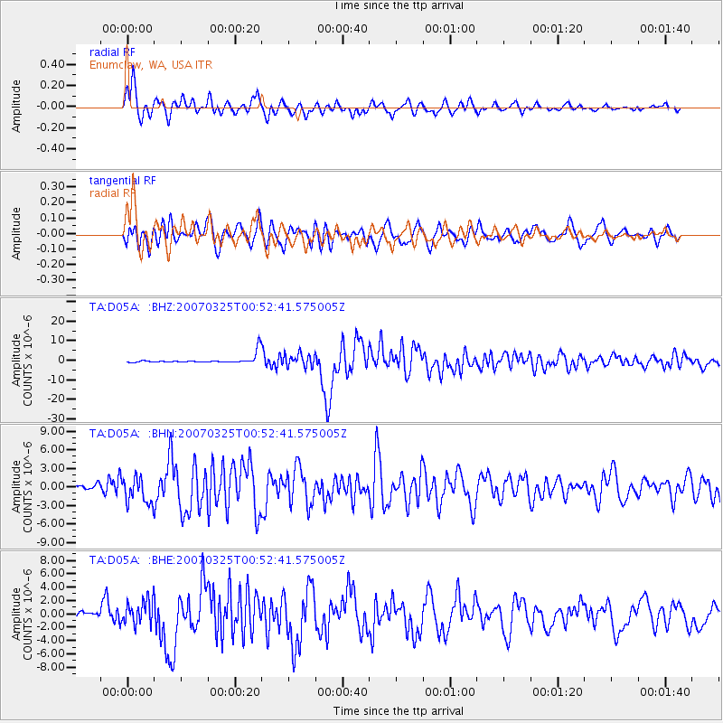
Earthquake location: Near West Coast Of Honshu, Japan
Earthquake latitude/longitude: 37.3/136.6
Earthquake time(UTC): 2007/03/25 (084) 00:41:57 GMT
Earthquake Depth: 8.0 km
Earthquake Magnitude: 6.1 MB, 6.8 MS, 6.7 MW, 6.6 MW
Earthquake Catalog/Contributor: WHDF/NEIC
Network: TA USArray Transportable Network (new EarthScope stations)
Station: D05A Enumclaw, WA, USA
Lat/Lon: 47.19 N/121.99 W
Elevation: 266 m
Distance: 70.5 deg
Az: 45.175 deg
Baz: 304.019 deg
Ray Param: 0.05495282
Estimated Moho Depth: 16.5 km
Estimated Crust Vp/Vs: 1.60
Assumed Crust Vp: 6.597 km/s
Estimated Crust Vs: 4.123 km/s
Estimated Crust Poisson's Ratio: 0.18
Radial Match: 86.922325 %
Radial Bump: 400
Transverse Match: 69.23789 %
Transverse Bump: 400
SOD ConfigId: 2564
Insert Time: 2010-03-06 02:59:19.895 +0000
GWidth: 2.5
Max Bumps: 400
Tol: 0.001

Signal To Noise

ChannelStoNSTALTA
TA:D05A: :BHN:20070325T00:52:41.575005Z5.35037952.1234825E-63.9688447E-7
TA:D05A: :BHE:20070325T00:52:41.575005Z5.407051.8119723E-63.351129E-7
TA:D05A: :BHZ:20070325T00:52:41.575005Z1.56260453.1855184E-62.0385955E-6
Arrivals
Ps1.6 SECOND
PpPs6.2 SECOND
PsPs/PpSs7.8 SECOND