You are here: Home > Network List > TA - USArray Transportable Network (new EarthScope stations) Stations List
> Station D05A Enumclaw, WA, USA > Earthquake Result Viewer
D05A Enumclaw, WA, USA - Earthquake Result Viewer
| Earthquake location: |
Kyushu, Japan |
| Earthquake latitude/longitude: |
33.1/131.1 |
| Earthquake time(UTC): |
2006/06/11 (162) 20:01:26 GMT |
| Earthquake Depth: |
140 km |
| Earthquake Magnitude: |
5.9 MB, 6.3 MW, 6.3 MW |
| Earthquake Catalog/Contributor: |
WHDF/NEIC |
|
| Network: |
TA USArray Transportable Network (new EarthScope stations) |
| Station: |
D05A Enumclaw, WA, USA |
| Lat/Lon: |
47.19 N/121.99 W |
| Elevation: |
266 m |
|
| Distance: |
76.6 deg |
| Az: |
42.141 deg |
| Baz: |
304.364 deg |
| Ray Param: |
0.05054357 |
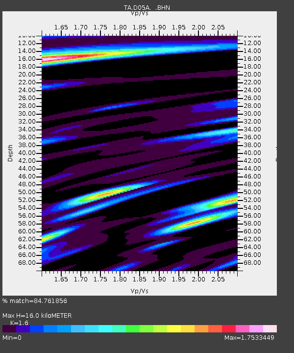
| Estimated Moho Depth: |
16.0 km |
| Estimated Crust Vp/Vs: |
1.60 |
| Assumed Crust Vp: |
6.597 km/s |
| Estimated Crust Vs: |
4.123 km/s |
| Estimated Crust Poisson's Ratio: |
0.18 |
|
| Radial Match: |
84.761856 % |
| Radial Bump: |
400 |
| Transverse Match: |
76.309235 % |
| Transverse Bump: |
400 |
| SOD ConfigId: |
5423 |
| Insert Time: |
2010-03-06 02:59:27.675 +0000 |
| GWidth: |
2.5 |
| Max Bumps: |
400 |
| Tol: |
0.001 |
|
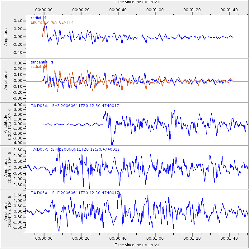
Signal To Noise
| Channel | StoN | STA | LTA |
| TA:D05A: :BHN:20060611T20:12:30.474001Z | 3.5395055 | 2.997319E-7 | 8.4681865E-8 |
| TA:D05A: :BHE:20060611T20:12:30.474001Z | 3.1834621 | 4.2217957E-7 | 1.3261649E-7 |
| TA:D05A: :BHZ:20060611T20:12:30.474001Z | 10.457865 | 1.2006136E-6 | 1.14804855E-7 |
| Arrivals |
| Ps | 1.5 SECOND |
| PpPs | 6.1 SECOND |
| PsPs/PpSs | 7.6 SECOND |


