You are here: Home > Network List > TA - USArray Transportable Network (new EarthScope stations) Stations List
> Station D05A Enumclaw, WA, USA > Earthquake Result Viewer
D05A Enumclaw, WA, USA - Earthquake Result Viewer
| Earthquake location: |
Near East Coast Of Kamchatka |
| Earthquake latitude/longitude: |
51.1/157.5 |
| Earthquake time(UTC): |
2006/08/24 (236) 21:50:36 GMT |
| Earthquake Depth: |
43 km |
| Earthquake Magnitude: |
5.9 MB, 6.2 MS, 6.5 MW, 6.5 MW |
| Earthquake Catalog/Contributor: |
WHDF/NEIC |
|
| Network: |
TA USArray Transportable Network (new EarthScope stations) |
| Station: |
D05A Enumclaw, WA, USA |
| Lat/Lon: |
47.19 N/121.99 W |
| Elevation: |
266 m |
|
| Distance: |
50.3 deg |
| Az: |
60.985 deg |
| Baz: |
306.139 deg |
| Ray Param: |
0.068058334 |
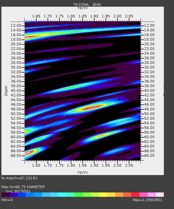
| Estimated Moho Depth: |
66.75 km |
| Estimated Crust Vp/Vs: |
1.61 |
| Assumed Crust Vp: |
6.597 km/s |
| Estimated Crust Vs: |
4.104 km/s |
| Estimated Crust Poisson's Ratio: |
0.18 |
|
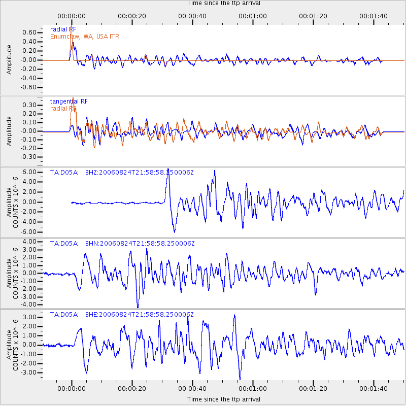
| Radial Match: |
87.23193 % |
| Radial Bump: |
400 |
| Transverse Match: |
67.88389 % |
| Transverse Bump: |
400 |
| SOD ConfigId: |
2665 |
| Insert Time: |
2010-03-06 02:59:30.471 +0000 |
| GWidth: |
2.5 |
| Max Bumps: |
400 |
| Tol: |
0.001 |
|
Signal To Noise
| Channel | StoN | STA | LTA |
| TA:D05A: :BHN:20060824T21:58:58.250006Z | 12.423339 | 1.2897611E-6 | 1.0381759E-7 |
| TA:D05A: :BHE:20060824T21:58:58.250006Z | 15.399658 | 1.3062665E-6 | 8.4824386E-8 |
| TA:D05A: :BHZ:20060824T21:58:58.250006Z | 36.146797 | 3.5934756E-6 | 9.9413384E-8 |
| Arrivals |
| Ps | 6.6 SECOND |
| PpPs | 25 SECOND |
| PsPs/PpSs | 31 SECOND |


