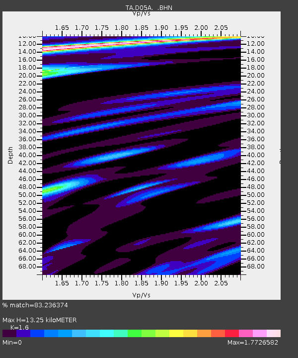
D05A Enumclaw, WA, USA - Earthquake Result Viewer
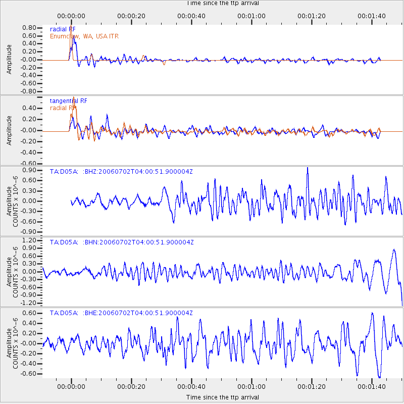
Earthquake location: Rat Islands, Aleutian Islands
Earthquake latitude/longitude: 51.7/176.9
Earthquake time(UTC): 2006/07/02 (183) 03:53:56 GMT
Earthquake Depth: 8.6 km
Earthquake Magnitude: 5.5 MB, 5.3 MS, 5.8 MW, 5.7 MW
Earthquake Catalog/Contributor: WHDF/NEIC
Network: TA USArray Transportable Network (new EarthScope stations)
Station: D05A Enumclaw, WA, USA
Lat/Lon: 47.19 N/121.99 W
Elevation: 266 m
Distance: 38.9 deg
Az: 71.757 deg
Baz: 299.963 deg
Ray Param: 0.075271636
Estimated Moho Depth: 13.25 km
Estimated Crust Vp/Vs: 1.60
Assumed Crust Vp: 6.597 km/s
Estimated Crust Vs: 4.123 km/s
Estimated Crust Poisson's Ratio: 0.18
Radial Match: 83.236374 %
Radial Bump: 313
Transverse Match: 72.094185 %
Transverse Bump: 400
SOD ConfigId: 2665
Insert Time: 2010-03-06 02:59:38.199 +0000
GWidth: 2.5
Max Bumps: 400
Tol: 0.001

Signal To Noise

ChannelStoNSTALTA
TA:D05A: :BHN:20060702T04:00:51.900004Z0.71329417.986808E-81.11970756E-7
TA:D05A: :BHE:20060702T04:00:51.900004Z1.39299451.1493323E-78.250802E-8
TA:D05A: :BHZ:20060702T04:00:51.900004Z2.88204483.0048514E-71.0426108E-7
Arrivals
Ps1.3 SECOND
PpPs4.8 SECOND
PsPs/PpSs6.1 SECOND