You are here: Home > Network List > TA - USArray Transportable Network (new EarthScope stations) Stations List
> Station D05A Enumclaw, WA, USA > Earthquake Result Viewer
D05A Enumclaw, WA, USA - Earthquake Result Viewer
| Earthquake location: |
Eastern Siberia, Russia |
| Earthquake latitude/longitude: |
60.5/167.5 |
| Earthquake time(UTC): |
2006/04/29 (119) 16:58:06 GMT |
| Earthquake Depth: |
11 km |
| Earthquake Magnitude: |
6.4 MB, 6.6 MS, 6.6 MW, 6.4 MW |
| Earthquake Catalog/Contributor: |
WHDF/NEIC |
|
| Network: |
TA USArray Transportable Network (new EarthScope stations) |
| Station: |
D05A Enumclaw, WA, USA |
| Lat/Lon: |
47.19 N/121.99 W |
| Elevation: |
266 m |
|
| Distance: |
41.6 deg |
| Az: |
75.674 deg |
| Baz: |
315.309 deg |
| Ray Param: |
0.07370601 |
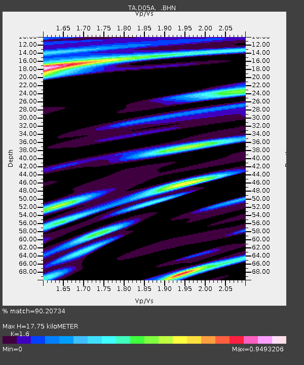
| Estimated Moho Depth: |
17.75 km |
| Estimated Crust Vp/Vs: |
1.60 |
| Assumed Crust Vp: |
6.597 km/s |
| Estimated Crust Vs: |
4.123 km/s |
| Estimated Crust Poisson's Ratio: |
0.18 |
|
| Radial Match: |
90.20734 % |
| Radial Bump: |
400 |
| Transverse Match: |
84.092606 % |
| Transverse Bump: |
400 |
| SOD ConfigId: |
2669 |
| Insert Time: |
2010-03-06 02:59:46.813 +0000 |
| GWidth: |
2.5 |
| Max Bumps: |
400 |
| Tol: |
0.001 |
|

Signal To Noise
| Channel | StoN | STA | LTA |
| TA:D05A: :BHN:20060429T17:05:23.075005Z | 1.5590471 | 4.2738606E-7 | 2.7413287E-7 |
| TA:D05A: :BHE:20060429T17:05:23.075005Z | 1.8654083 | 3.4499368E-7 | 1.849427E-7 |
| TA:D05A: :BHZ:20060429T17:05:23.075005Z | 4.4478436 | 1.0056359E-6 | 2.2609517E-7 |
| Arrivals |
| Ps | 1.8 SECOND |
| PpPs | 6.5 SECOND |
| PsPs/PpSs | 8.2 SECOND |


