You are here: Home > Network List > TA - USArray Transportable Network (new EarthScope stations) Stations List
> Station D05A Enumclaw, WA, USA > Earthquake Result Viewer
D05A Enumclaw, WA, USA - Earthquake Result Viewer
| Earthquake location: |
Eastern Siberia, Russia |
| Earthquake latitude/longitude: |
60.9/167.1 |
| Earthquake time(UTC): |
2006/04/20 (110) 23:25:02 GMT |
| Earthquake Depth: |
22 km |
| Earthquake Magnitude: |
6.8 MB, 7.6 MS, 7.6 MW, 7.3 MW |
| Earthquake Catalog/Contributor: |
WHDF/NEIC |
|
| Network: |
TA USArray Transportable Network (new EarthScope stations) |
| Station: |
D05A Enumclaw, WA, USA |
| Lat/Lon: |
47.19 N/121.99 W |
| Elevation: |
266 m |
|
| Distance: |
41.7 deg |
| Az: |
75.862 deg |
| Baz: |
316.057 deg |
| Ray Param: |
0.07361799 |
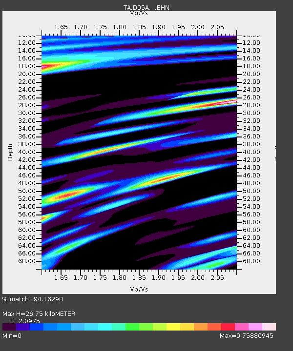
| Estimated Moho Depth: |
26.75 km |
| Estimated Crust Vp/Vs: |
2.10 |
| Assumed Crust Vp: |
6.597 km/s |
| Estimated Crust Vs: |
3.145 km/s |
| Estimated Crust Poisson's Ratio: |
0.35 |
|
| Radial Match: |
94.16298 % |
| Radial Bump: |
400 |
| Transverse Match: |
78.032394 % |
| Transverse Bump: |
400 |
| SOD ConfigId: |
2669 |
| Insert Time: |
2010-03-06 02:59:50.678 +0000 |
| GWidth: |
2.5 |
| Max Bumps: |
400 |
| Tol: |
0.001 |
|
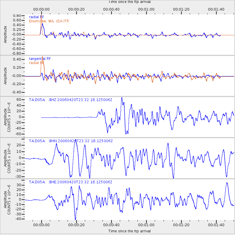
Signal To Noise
| Channel | StoN | STA | LTA |
| TA:D05A: :BHN:20060420T23:32:18.125006Z | 7.6671176 | 4.8280435E-6 | 6.297078E-7 |
| TA:D05A: :BHE:20060420T23:32:18.125006Z | 8.66749 | 4.4214607E-6 | 5.101201E-7 |
| TA:D05A: :BHZ:20060420T23:32:18.125006Z | 25.118015 | 1.2823176E-5 | 5.105171E-7 |
| Arrivals |
| Ps | 4.7 SECOND |
| PpPs | 12 SECOND |
| PsPs/PpSs | 17 SECOND |


