You are here: Home > Network List > TA - USArray Transportable Network (new EarthScope stations) Stations List
> Station D05A Enumclaw, WA, USA > Earthquake Result Viewer
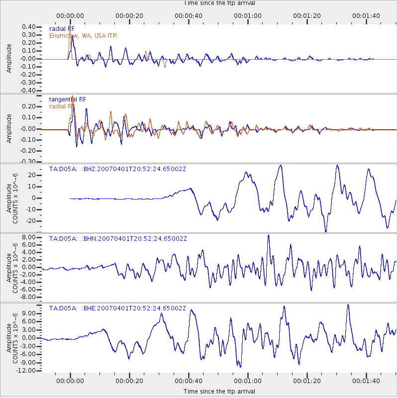
D05A Enumclaw, WA, USA - Earthquake Result Viewer
*The percent match for this event was below the threshold and hence no stack was calculated.
| Earthquake location: |
Solomon Islands |
| Earthquake latitude/longitude: |
-8.5/157.0 |
| Earthquake time(UTC): |
2007/04/01 (091) 20:39:56 GMT |
| Earthquake Depth: |
10 km |
| Earthquake Magnitude: |
6.8 MB, 7.9 MS, 8.1 MW, 7.7 ME |
| Earthquake Catalog/Contributor: |
WHDF/NEIC |
|
| Network: |
TA USArray Transportable Network (new EarthScope stations) |
| Station: |
D05A Enumclaw, WA, USA |
| Lat/Lon: |
47.19 N/121.99 W |
| Elevation: |
266 m |
|
| Distance: |
90.1 deg |
| Az: |
42.345 deg |
| Baz: |
257.686 deg |
| Ray Param: |
$rayparam |
*The percent match for this event was below the threshold and hence was not used in the summary stack. |
|
| Radial Match: |
94.73904 % |
| Radial Bump: |
400 |
| Transverse Match: |
89.77204 % |
| Transverse Bump: |
400 |
| SOD ConfigId: |
2564 |
| Insert Time: |
2010-03-06 02:59:52.769 +0000 |
| GWidth: |
2.5 |
| Max Bumps: |
400 |
| Tol: |
0.001 |
|
Signal To Noise
| Channel | StoN | STA | LTA |
| TA:D05A: :BHN:20070401T20:52:24.65002Z | 1.2641218 | 1.8511888E-7 | 1.464407E-7 |
| TA:D05A: :BHE:20070401T20:52:24.65002Z | 2.2548099 | 5.22201E-7 | 2.3159424E-7 |
| TA:D05A: :BHZ:20070401T20:52:24.65002Z | 10.010699 | 1.6849948E-6 | 1.683194E-7 |
| Arrivals |
| Ps | |
| PpPs | |
| PsPs/PpSs | |


