You are here: Home > Network List > TA - USArray Transportable Network (new EarthScope stations) Stations List
> Station C03A Quillayute Airport, Forks, WA, USA > Earthquake Result Viewer
C03A Quillayute Airport, Forks, WA, USA - Earthquake Result Viewer
| Earthquake location: |
South Of Fiji Islands |
| Earthquake latitude/longitude: |
-26.0/-177.5 |
| Earthquake time(UTC): |
2007/12/09 (343) 07:28:20 GMT |
| Earthquake Depth: |
152 km |
| Earthquake Magnitude: |
7.0 MB, 7.8 MW, 7.7 MW |
| Earthquake Catalog/Contributor: |
WHDF/NEIC |
|
| Network: |
TA USArray Transportable Network (new EarthScope stations) |
| Station: |
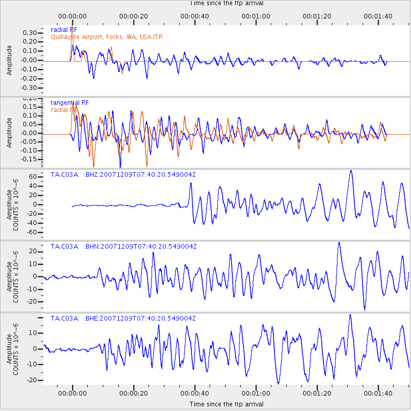
C03A Quillayute Airport, Forks, WA, USA |
| Lat/Lon: |
47.95 N/124.57 W |
| Elevation: |
48 m |
|
| Distance: |
87.6 deg |
| Az: |
32.481 deg |
| Baz: |
225.963 deg |
| Ray Param: |
0.04286332 |
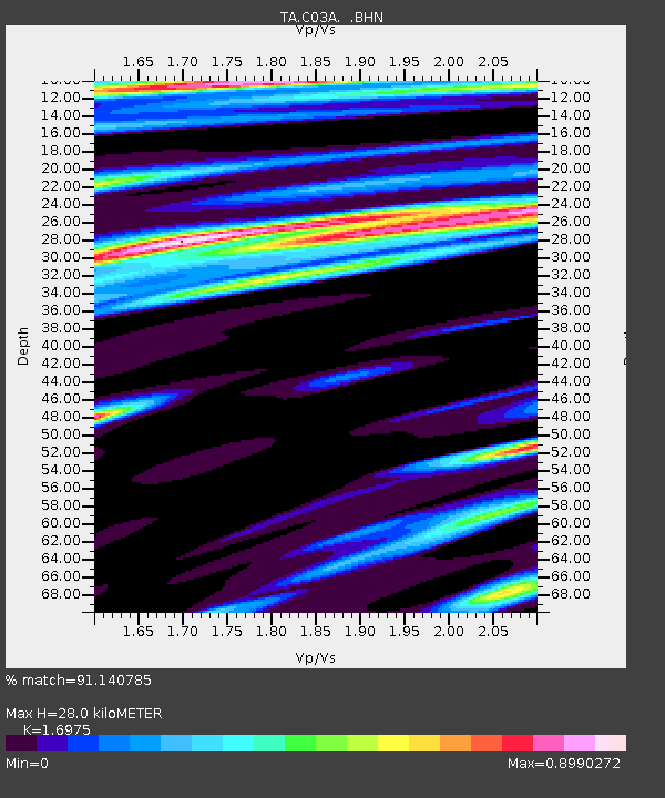
| Estimated Moho Depth: |
28.0 km |
| Estimated Crust Vp/Vs: |
1.70 |
| Assumed Crust Vp: |
6.134 km/s |
| Estimated Crust Vs: |
3.613 km/s |
| Estimated Crust Poisson's Ratio: |
0.23 |
|
| Radial Match: |
91.140785 % |
| Radial Bump: |
400 |
| Transverse Match: |
87.88111 % |
| Transverse Bump: |
400 |
| SOD ConfigId: |
2564 |
| Insert Time: |
2010-03-06 03:44:21.872 +0000 |
| GWidth: |
2.5 |
| Max Bumps: |
400 |
| Tol: |
0.001 |
|
Signal To Noise
| Channel | StoN | STA | LTA |
| TA:C03A: :BHN:20071209T07:40:20.549004Z | 0.624309 | 5.9687767E-7 | 9.560613E-7 |
| TA:C03A: :BHE:20071209T07:40:20.549004Z | 0.32086855 | 4.282278E-7 | 1.3345895E-6 |
| TA:C03A: :BHZ:20071209T07:40:20.549004Z | 2.3089767 | 2.53028E-6 | 1.0958448E-6 |
| Arrivals |
| Ps | 3.3 SECOND |
| PpPs | 12 SECOND |
| PsPs/PpSs | 15 SECOND |


