
Station TA C03A - Quillayute Airport, Forks, WA, USA
Network: TA - USArray Transportable Network (new EarthScope stations)
Nearby stations (2 deg radius)
| Station | Name | (Lat, Lon) | Start / End | Elevation |
| C03A | Quillayute Airport, Forks, WA, USA | (47.95, -124.57) | 2005-10-20 / 2499-01-01 | 0.0 km |
| Crust2 Type: | C3,continental shelf, 2 km seds. |
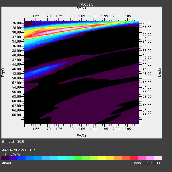
| Thickness Estimate: | 29 km |
| Thickness StdDev: | 0.9 km |
| Vp/Vs Estimate: | 1.76 |
| Vp/Vs StdDev: | 0.06 |
| Vs Estimate: | 3.49 km/s |
| Poisson's Ratio: | 0.26 |
| Peak Value: | 0.07 |
| Assumed Vp: | 6.134 km/s |
| Ps Weight: | 0.33333334 |
| PpPs Weight: | 0.33333334 |
| PsPs Weight: | 0.33333328 |
| Residual Complexity: | 0.523 |
| Nearby stations H: | +- |
| (2.0 deg) Vp/Vs: | +- |
6 with match > 90% ( 46.153847 %) and 13 with match > 80% ( 100.0 %) out of 13.
Download stack as xyz text file.
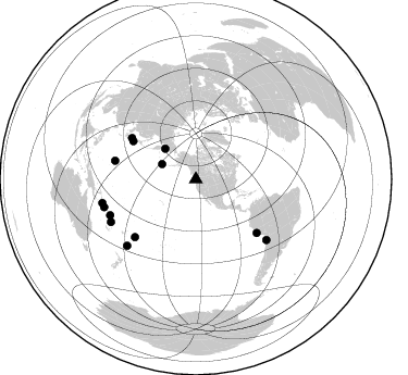
Azimuth Distribution of Events:
Prior Results for this Station
| Study | Thickness | Vp/Vs | Vp | Vs | Poissons Ratio | Extra |
| EARS | 29 km | 1.76 | 6.134 km/s | 3.49 km/s | 0.26 | |
| Crust2.0 | 31 km | 1.80 | 6.134 km/s | 3.406 km/s | 0.28 | C3,continental shelf, 2 km seds. |
| Global Maxima | 29 km | 1.76 | 6.134 km/s | 3.49 km/s | 0.26 | amp=0.06873814 |
| Local Maxima 1 | 28 km | 1.67 | 6.134 km/s | 3.678 km/s | 0.22 | amp=0.04429175 |
| Local Maxima 2 | 32 km | 1.60 | 6.134 km/s | 3.834 km/s | 0.18 | amp=0.032794308 |
| Local Maxima 3 | 26 km | 1.94 | 6.134 km/s | 3.166 km/s | 0.32 | amp=0.023921456 |
| Local Maxima 4 | 46 km | 1.66 | 6.134 km/s | 3.684 km/s | 0.22 | amp=0.012354223 |
| Predicted Arrivals for vertical incidence (zero ray parameter) | |
| Ps | 3.58 SECOND |
| PpPs | 13.04 SECOND |
| PsPs/PpSs | 16.62 SECOND |
Events Processed for this Station
Download zip of receiver functions as SAC
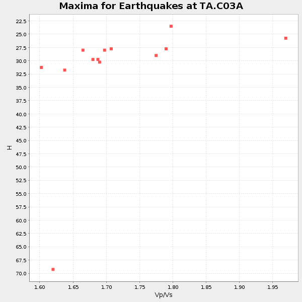
Plot maxima for each earthquake.
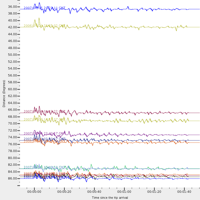
Events Used in the Stack
(13 events)| Radial Match | Distance | Baz | FERegion | Time | Lat/Lon | Depth | Magnitude |
| 96.856544 | 88.5 deg | 255.775 deg | Solomon Islands | 2007/04/01 20:39:56 GMT | (-8.5, 157.0) | 10 km | 6.8 MB, 7.9 MS, 8.1 MW, 7.7 ME |
| 95.54974 | 88.0 deg | 253.075 deg | Solomon Islands | 2007/08/16 08:39:27 GMT | (-9.8, 159.5) | 10 km | 6.1 MB, 6.7 MS, 6.4 MW |
| 93.67474 | 85.3 deg | 130.676 deg | Northern Chile | 2007/11/14 15:40:50 GMT | (-22.2, -69.9) | 40 km | 6.7 MB, 7.4 MS, 7.7 MW, 7.4 ME |
| 91.15978 | 87.3 deg | 243.244 deg | Vanuatu Islands | 2007/08/01 17:08:51 GMT | (-15.6, 167.7) | 120 km | 6.2 MB, 7.2 MW, 7.2 MW |
| 91.140785 | 87.6 deg | 225.963 deg | South Of Fiji Islands | 2007/12/09 07:28:20 GMT | (-26.0, -177.5) | 152 km | 7.0 MB, 7.8 MW, 7.7 MW |
| 90.73784 | 34.1 deg | 294.226 deg | Andreanof Islands, Aleutian Is. | 2007/08/15 20:22:11 GMT | (50.3, -177.5) | 9.0 km | 6.3 MB, 6.2 MS, 6.4 MW, 5.9 ML |
| 89.42976 | 85.4 deg | 247.19 deg | Santa Cruz Islands | 2007/09/02 01:05:18 GMT | (-11.6, 165.8) | 35 km | 5.9 MB, 7.3 MS, 7.2 MW, 6.9 ME |
| 88.86195 | 67.4 deg | 301.284 deg | Near West Coast Of Honshu, Japan | 2007/07/16 01:13:22 GMT | (37.5, 138.4) | 12 km | 6.5 MB, 6.4 MS, 6.6 MW, 6.5 MW |
| 88.38951 | 74.5 deg | 131.393 deg | Near Coast Of Peru | 2007/08/15 23:40:57 GMT | (-13.4, -76.6) | 39 km | 6.7 MB, 7.9 MS, 8.0 MW, 7.5 ME |
| 88.10461 | 77.0 deg | 226.494 deg | Samoa Islands Region | 2006/09/28 06:22:09 GMT | (-16.6, -172.0) | 28 km | 6.5 MB, 6.6 MS, 6.9 MW, 6.7 MW |
| 86.950485 | 39.9 deg | 314.987 deg | Eastern Siberia, Russia | 2006/04/20 23:25:02 GMT | (60.9, 167.1) | 22 km | 6.8 MB, 7.6 MS, 7.6 MW, 7.3 MW |
| 82.43929 | 70.0 deg | 302.89 deg | Sea Of Japan | 2007/07/16 14:17:37 GMT | (36.8, 134.9) | 350 km | 6.2 MB, 6.8 MW, 6.8 MW |
| 81.18864 | 76.3 deg | 282.925 deg | Mariana Islands | 2007/10/31 03:30:17 GMT | (18.9, 145.4) | 223 km | 6.2 MB, 7.2 MW, 7.2 MW |
Losers
(0 events)| Radial Match | Distance | Baz | FERegion | Time | Lat/Lon | Depth | Magnitude | Reason |
