You are here: Home > Network List > TA - USArray Transportable Network (new EarthScope stations) Stations List
> Station C03A Quillayute Airport, Forks, WA, USA > Earthquake Result Viewer
C03A Quillayute Airport, Forks, WA, USA - Earthquake Result Viewer
| Earthquake location: |
Northern Chile |
| Earthquake latitude/longitude: |
-22.2/-69.9 |
| Earthquake time(UTC): |
2007/11/14 (318) 15:40:50 GMT |
| Earthquake Depth: |
40 km |
| Earthquake Magnitude: |
6.7 MB, 7.4 MS, 7.7 MW, 7.4 ME |
| Earthquake Catalog/Contributor: |
WHDF/NEIC |
|
| Network: |
TA USArray Transportable Network (new EarthScope stations) |
| Station: |
C03A Quillayute Airport, Forks, WA, USA |
| Lat/Lon: |
47.95 N/124.57 W |
| Elevation: |
48 m |
|
| Distance: |
85.3 deg |
| Az: |
326.609 deg |
| Baz: |
130.676 deg |
| Ray Param: |
0.044783775 |
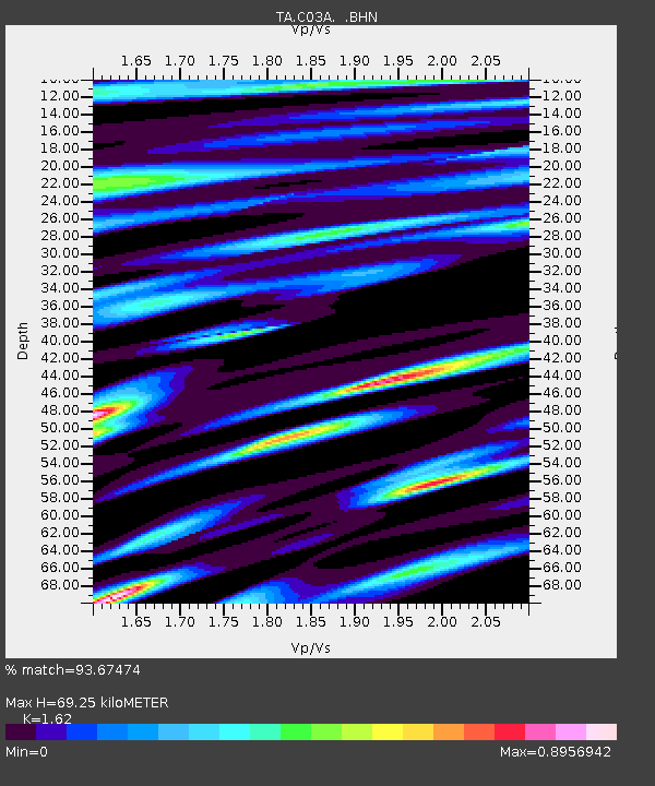
| Estimated Moho Depth: |
69.25 km |
| Estimated Crust Vp/Vs: |
1.62 |
| Assumed Crust Vp: |
6.134 km/s |
| Estimated Crust Vs: |
3.786 km/s |
| Estimated Crust Poisson's Ratio: |
0.19 |
|
| Radial Match: |
93.67474 % |
| Radial Bump: |
400 |
| Transverse Match: |
82.10415 % |
| Transverse Bump: |
400 |
| SOD ConfigId: |
2564 |
| Insert Time: |
2010-03-06 03:44:23.602 +0000 |
| GWidth: |
2.5 |
| Max Bumps: |
400 |
| Tol: |
0.001 |
|
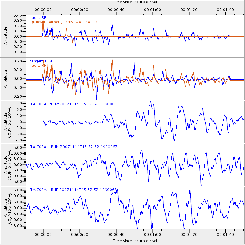
Signal To Noise
| Channel | StoN | STA | LTA |
| TA:C03A: :BHN:20071114T15:52:52.199006Z | 0.67995584 | 1.2755006E-6 | 1.8758581E-6 |
| TA:C03A: :BHE:20071114T15:52:52.199006Z | 1.4048234 | 2.228939E-6 | 1.5866328E-6 |
| TA:C03A: :BHZ:20071114T15:52:52.199006Z | 2.847666 | 5.0061276E-6 | 1.7579757E-6 |
| Arrivals |
| Ps | 7.2 SECOND |
| PpPs | 29 SECOND |
| PsPs/PpSs | 36 SECOND |


