You are here: Home > Network List > TA - USArray Transportable Network (new EarthScope stations) Stations List
> Station C03A Quillayute Airport, Forks, WA, USA > Earthquake Result Viewer
C03A Quillayute Airport, Forks, WA, USA - Earthquake Result Viewer
| Earthquake location: |
Santa Cruz Islands |
| Earthquake latitude/longitude: |
-11.6/165.8 |
| Earthquake time(UTC): |
2007/09/02 (245) 01:05:18 GMT |
| Earthquake Depth: |
35 km |
| Earthquake Magnitude: |
5.9 MB, 7.3 MS, 7.2 MW, 6.9 ME |
| Earthquake Catalog/Contributor: |
WHDF/NEIC |
|
| Network: |
TA USArray Transportable Network (new EarthScope stations) |
| Station: |
C03A Quillayute Airport, Forks, WA, USA |
| Lat/Lon: |
47.95 N/124.57 W |
| Elevation: |
48 m |
|
| Distance: |
85.4 deg |
| Az: |
39.234 deg |
| Baz: |
247.19 deg |
| Ray Param: |
0.04476959 |
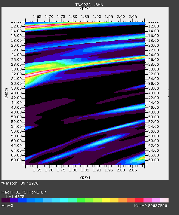
| Estimated Moho Depth: |
31.75 km |
| Estimated Crust Vp/Vs: |
1.64 |
| Assumed Crust Vp: |
6.134 km/s |
| Estimated Crust Vs: |
3.746 km/s |
| Estimated Crust Poisson's Ratio: |
0.20 |
|
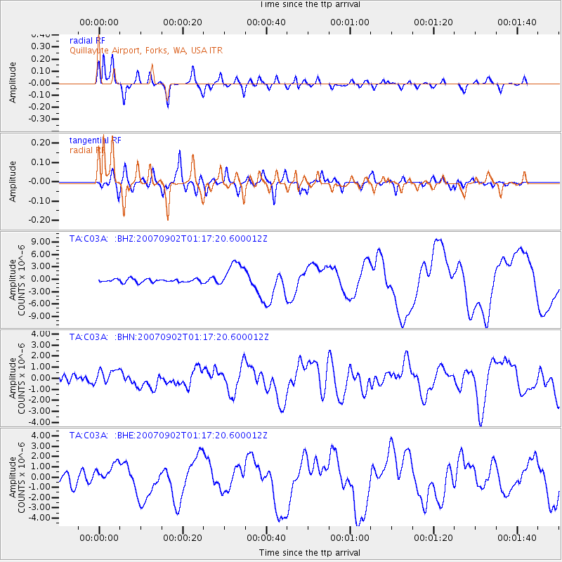
| Radial Match: |
89.42976 % |
| Radial Bump: |
400 |
| Transverse Match: |
79.24854 % |
| Transverse Bump: |
400 |
| SOD ConfigId: |
2564 |
| Insert Time: |
2010-03-06 03:44:27.191 +0000 |
| GWidth: |
2.5 |
| Max Bumps: |
400 |
| Tol: |
0.001 |
|
Signal To Noise
| Channel | StoN | STA | LTA |
| TA:C03A: :BHN:20070902T01:17:20.600012Z | 1.8353469 | 6.499319E-7 | 3.5411938E-7 |
| TA:C03A: :BHE:20070902T01:17:20.600012Z | 2.0494335 | 1.0586526E-6 | 5.165587E-7 |
| TA:C03A: :BHZ:20070902T01:17:20.600012Z | 8.363316 | 3.3267377E-6 | 3.9777734E-7 |
| Arrivals |
| Ps | 3.4 SECOND |
| PpPs | 13 SECOND |
| PsPs/PpSs | 17 SECOND |


