You are here: Home > Network List > TA - USArray Transportable Network (new EarthScope stations) Stations List
> Station C03A Quillayute Airport, Forks, WA, USA > Earthquake Result Viewer
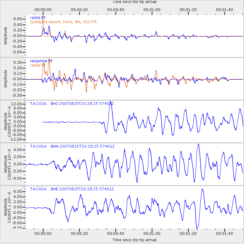
C03A Quillayute Airport, Forks, WA, USA - Earthquake Result Viewer
| Earthquake location: |
Andreanof Islands, Aleutian Is. |
| Earthquake latitude/longitude: |
50.3/-177.5 |
| Earthquake time(UTC): |
2007/08/15 (227) 20:22:11 GMT |
| Earthquake Depth: |
9.0 km |
| Earthquake Magnitude: |
6.3 MB, 6.2 MS, 6.4 MW, 5.9 ML |
| Earthquake Catalog/Contributor: |
WHDF/NEIC |
|
| Network: |
TA USArray Transportable Network (new EarthScope stations) |
| Station: |
C03A Quillayute Airport, Forks, WA, USA |
| Lat/Lon: |
47.95 N/124.57 W |
| Elevation: |
48 m |
|
| Distance: |
34.1 deg |
| Az: |
73.024 deg |
| Baz: |
294.226 deg |
| Ray Param: |
0.077885695 |
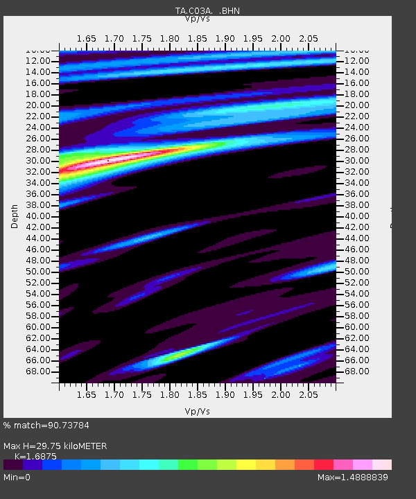
| Estimated Moho Depth: |
29.75 km |
| Estimated Crust Vp/Vs: |
1.69 |
| Assumed Crust Vp: |
6.134 km/s |
| Estimated Crust Vs: |
3.635 km/s |
| Estimated Crust Poisson's Ratio: |
0.23 |
|
| Radial Match: |
90.73784 % |
| Radial Bump: |
400 |
| Transverse Match: |
84.525635 % |
| Transverse Bump: |
400 |
| SOD ConfigId: |
2564 |
| Insert Time: |
2010-03-06 03:44:33.866 +0000 |
| GWidth: |
2.5 |
| Max Bumps: |
400 |
| Tol: |
0.001 |
|
Signal To Noise
| Channel | StoN | STA | LTA |
| TA:C03A: :BHN:20070815T20:28:25.57401Z | 1.1334456 | 2.2807548E-7 | 2.0122312E-7 |
| TA:C03A: :BHE:20070815T20:28:25.57401Z | 5.4812007 | 6.7572466E-7 | 1.2328042E-7 |
| TA:C03A: :BHZ:20070815T20:28:25.57401Z | 13.776351 | 2.3247308E-6 | 1.6874793E-7 |
| Arrivals |
| Ps | 3.6 SECOND |
| PpPs | 12 SECOND |
| PsPs/PpSs | 16 SECOND |


