You are here: Home > Network List > TA - USArray Transportable Network (new EarthScope stations) Stations List
> Station C03A Quillayute Airport, Forks, WA, USA > Earthquake Result Viewer
C03A Quillayute Airport, Forks, WA, USA - Earthquake Result Viewer
| Earthquake location: |
Solomon Islands |
| Earthquake latitude/longitude: |
-8.5/157.0 |
| Earthquake time(UTC): |
2007/04/01 (091) 20:39:56 GMT |
| Earthquake Depth: |
10 km |
| Earthquake Magnitude: |
6.8 MB, 7.9 MS, 8.1 MW, 7.7 ME |
| Earthquake Catalog/Contributor: |
WHDF/NEIC |
|
| Network: |
TA USArray Transportable Network (new EarthScope stations) |
| Station: |
C03A Quillayute Airport, Forks, WA, USA |
| Lat/Lon: |
47.95 N/124.57 W |
| Elevation: |
48 m |
|
| Distance: |
88.5 deg |
| Az: |
41.205 deg |
| Baz: |
255.775 deg |
| Ray Param: |
0.04251806 |
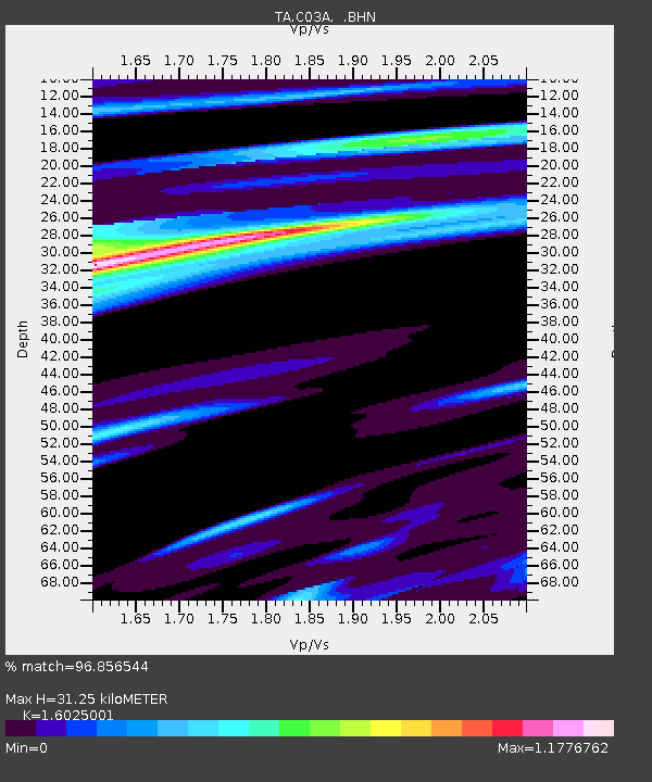
| Estimated Moho Depth: |
31.25 km |
| Estimated Crust Vp/Vs: |
1.60 |
| Assumed Crust Vp: |
6.134 km/s |
| Estimated Crust Vs: |
3.828 km/s |
| Estimated Crust Poisson's Ratio: |
0.18 |
|
| Radial Match: |
96.856544 % |
| Radial Bump: |
363 |
| Transverse Match: |
91.83484 % |
| Transverse Bump: |
400 |
| SOD ConfigId: |
2564 |
| Insert Time: |
2010-03-06 03:44:41.223 +0000 |
| GWidth: |
2.5 |
| Max Bumps: |
400 |
| Tol: |
0.001 |
|
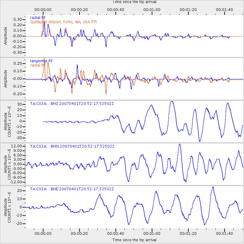
Signal To Noise
| Channel | StoN | STA | LTA |
| TA:C03A: :BHN:20070401T20:52:17.52502Z | 0.62745184 | 5.0593593E-7 | 8.0633424E-7 |
| TA:C03A: :BHE:20070401T20:52:17.52502Z | 1.2507604 | 8.48308E-7 | 6.782338E-7 |
| TA:C03A: :BHZ:20070401T20:52:17.52502Z | 3.0558646 | 2.1933697E-6 | 7.177575E-7 |
| Arrivals |
| Ps | 3.1 SECOND |
| PpPs | 13 SECOND |
| PsPs/PpSs | 16 SECOND |


