You are here: Home > Network List > TA - USArray Transportable Network (new EarthScope stations) Stations List
> Station C03A Quillayute Airport, Forks, WA, USA > Earthquake Result Viewer
C03A Quillayute Airport, Forks, WA, USA - Earthquake Result Viewer
| Earthquake location: |
Eastern Siberia, Russia |
| Earthquake latitude/longitude: |
60.9/167.1 |
| Earthquake time(UTC): |
2006/04/20 (110) 23:25:02 GMT |
| Earthquake Depth: |
22 km |
| Earthquake Magnitude: |
6.8 MB, 7.6 MS, 7.6 MW, 7.3 MW |
| Earthquake Catalog/Contributor: |
WHDF/NEIC |
|
| Network: |
TA USArray Transportable Network (new EarthScope stations) |
| Station: |
C03A Quillayute Airport, Forks, WA, USA |
| Lat/Lon: |
47.95 N/124.57 W |
| Elevation: |
48 m |
|
| Distance: |
39.9 deg |
| Az: |
76.953 deg |
| Baz: |
314.987 deg |
| Ray Param: |
0.07468151 |
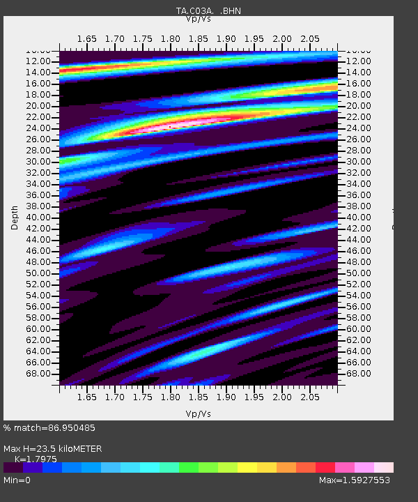
| Estimated Moho Depth: |
23.5 km |
| Estimated Crust Vp/Vs: |
1.80 |
| Assumed Crust Vp: |
6.134 km/s |
| Estimated Crust Vs: |
3.412 km/s |
| Estimated Crust Poisson's Ratio: |
0.28 |
|
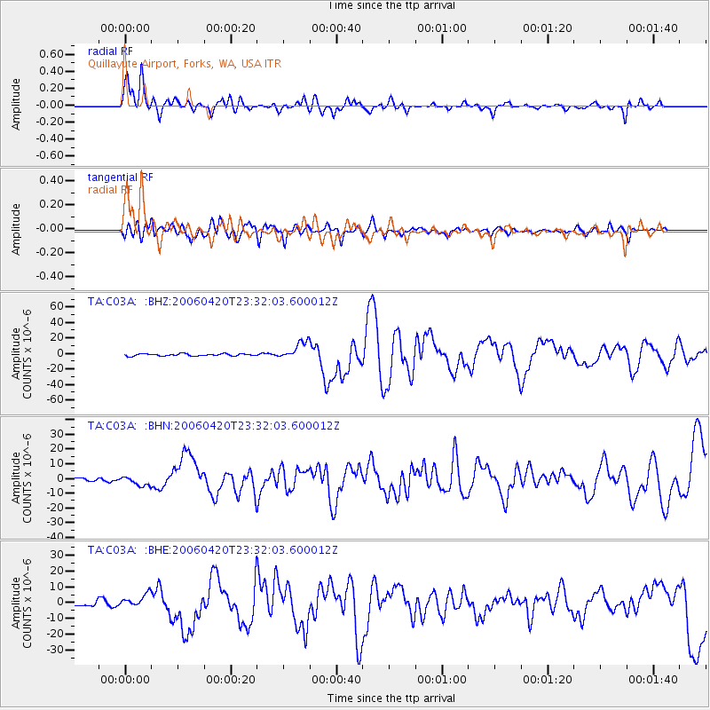
| Radial Match: |
86.950485 % |
| Radial Bump: |
400 |
| Transverse Match: |
77.19332 % |
| Transverse Bump: |
400 |
| SOD ConfigId: |
2669 |
| Insert Time: |
2010-03-06 03:44:46.004 +0000 |
| GWidth: |
2.5 |
| Max Bumps: |
400 |
| Tol: |
0.001 |
|
Signal To Noise
| Channel | StoN | STA | LTA |
| TA:C03A: :BHN:20060420T23:32:03.600012Z | 2.419664 | 3.3145345E-6 | 1.3698326E-6 |
| TA:C03A: :BHE:20060420T23:32:03.600012Z | 2.546485 | 4.305278E-6 | 1.6906748E-6 |
| TA:C03A: :BHZ:20060420T23:32:03.600012Z | 8.667735 | 1.1623769E-5 | 1.3410388E-6 |
| Arrivals |
| Ps | 3.3 SECOND |
| PpPs | 10 SECOND |
| PsPs/PpSs | 13 SECOND |


