You are here: Home > Network List > TA - USArray Transportable Network (new EarthScope stations) Stations List
> Station J02A Umpqua, OR, USA > Earthquake Result Viewer
J02A Umpqua, OR, USA - Earthquake Result Viewer
| Earthquake location: |
Volcano Islands, Japan Region |
| Earthquake latitude/longitude: |
22.0/142.7 |
| Earthquake time(UTC): |
2007/09/28 (271) 13:38:59 GMT |
| Earthquake Depth: |
276 km |
| Earthquake Magnitude: |
6.7 MB, 7.4 MW, 7.4 MW |
| Earthquake Catalog/Contributor: |
WHDF/NEIC |
|
| Network: |
TA USArray Transportable Network (new EarthScope stations) |
| Station: |
J02A Umpqua, OR, USA |
| Lat/Lon: |
43.37 N/123.57 W |
| Elevation: |
136 m |
|
| Distance: |
77.9 deg |
| Az: |
48.104 deg |
| Baz: |
288.702 deg |
| Ray Param: |
0.049298435 |
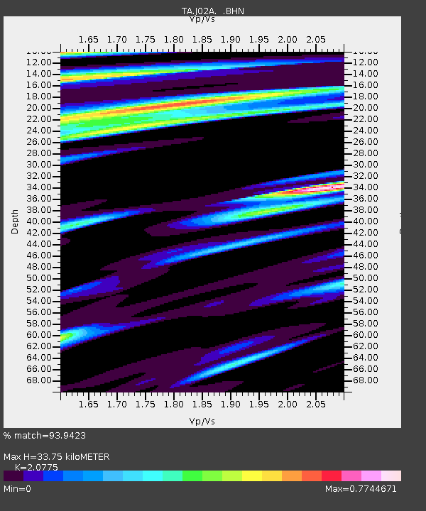
| Estimated Moho Depth: |
33.75 km |
| Estimated Crust Vp/Vs: |
2.08 |
| Assumed Crust Vp: |
6.522 km/s |
| Estimated Crust Vs: |
3.139 km/s |
| Estimated Crust Poisson's Ratio: |
0.35 |
|
| Radial Match: |
93.9423 % |
| Radial Bump: |
400 |
| Transverse Match: |
77.05347 % |
| Transverse Bump: |
400 |
| SOD ConfigId: |
2564 |
| Insert Time: |
2010-03-06 03:46:45.520 +0000 |
| GWidth: |
2.5 |
| Max Bumps: |
400 |
| Tol: |
0.001 |
|

Signal To Noise
| Channel | StoN | STA | LTA |
| TA:J02A: :BHN:20070928T13:49:55.700024Z | 7.9730697 | 1.6111032E-6 | 2.0206814E-7 |
| TA:J02A: :BHE:20070928T13:49:55.700024Z | 25.519648 | 4.7690883E-6 | 1.8687908E-7 |
| TA:J02A: :BHZ:20070928T13:49:55.700024Z | 56.578545 | 1.5089865E-5 | 2.6670648E-7 |
| Arrivals |
| Ps | 5.7 SECOND |
| PpPs | 16 SECOND |
| PsPs/PpSs | 21 SECOND |


