
Station TA J02A - Umpqua, OR, USA
Network: TA - USArray Transportable Network (new EarthScope stations)
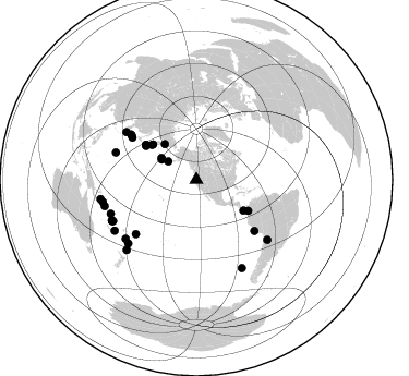
Nearby stations (2 deg radius)
| Station | Name | (Lat, Lon) | Start / End | Elevation |
| J02A | Umpqua, OR, USA | (43.37, -123.57) | 2005-11-16 / 2499-01-01 | 0.1 km |
| Crust2 Type: | LC,continental arc, Cordilleras, 1.0 km seds. |
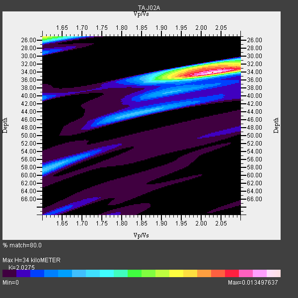
| Thickness Estimate: | 34 km |
| Thickness StdDev: | 2.7 km |
| Vp/Vs Estimate: | 2.03 |
| Vp/Vs StdDev: | 0.13 |
| Vs Estimate: | 3.217 km/s |
| Poisson's Ratio: | 0.34 |
| Peak Value: | 0.01 |
| Assumed Vp: | 6.522 km/s |
| Ps Weight: | 0.33333334 |
| PpPs Weight: | 0.33333334 |
| PsPs Weight: | 0.33333328 |
| Residual Complexity: | 0.533 |
| Nearby stations H: | +- |
| (2.0 deg) Vp/Vs: | +- |
14 with match > 90% ( 45.16129 %) and 31 with match > 80% ( 100.0 %) out of 31.
Download stack as xyz text file.
Azimuth Distribution of Events:
Prior Results for this Station
| Study | Thickness | Vp/Vs | Vp | Vs | Poissons Ratio | Extra |
| EARS | 34 km | 2.03 | 6.522 km/s | 3.217 km/s | 0.34 | |
| Crust2.0 | 37 km | 1.77 | 6.522 km/s | 3.676 km/s | 0.27 | LC,continental arc, Cordilleras, 1.0 km seds. |
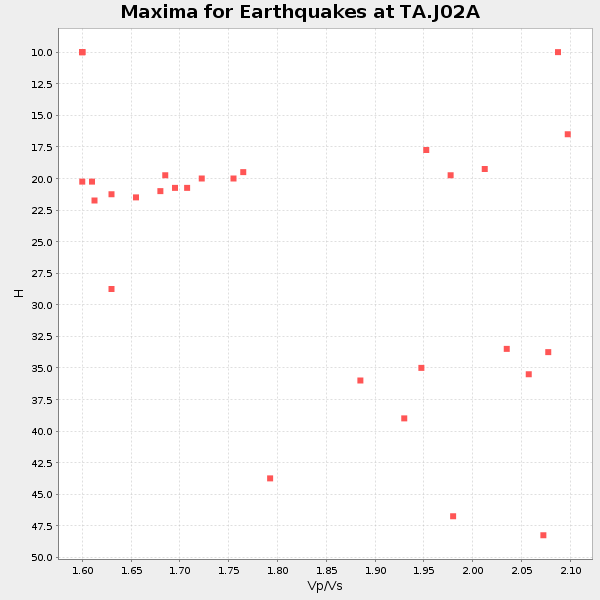
| Global Maxima | 34 km | 2.03 | 6.522 km/s | 3.217 km/s | 0.34 | amp=0.013497637 |
| Local Maxima 1 | 25 km | 1.60 | 6.522 km/s | 4.076 km/s | 0.18 | amp=0.008924673 |
| Local Maxima 2 | 33 km | 2.00 | 6.522 km/s | 3.265 km/s | 0.33 | amp=0.007497346 |
| Local Maxima 3 | 44 km | 1.86 | 6.522 km/s | 3.506 km/s | 0.30 | amp=0.0037383558 |
| Local Maxima 4 | 57 km | 1.64 | 6.522 km/s | 3.977 km/s | 0.20 | amp=0.0026100667 |
| Predicted Arrivals for vertical incidence (zero ray parameter) | |
| Ps | 5.36 SECOND |
| PpPs | 15.78 SECOND |
| PsPs/PpSs | 21.14 SECOND |
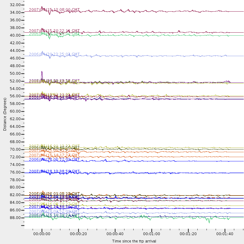
Events Processed for this Station
Download zip of receiver functions as SAC
Plot maxima for each earthquake.
Events Used in the Stack
(31 events)| Radial Match | Distance | Baz | FERegion | Time | Lat/Lon | Depth | Magnitude |
| 97.802 | 56.3 deg | 304.576 deg | Kuril Islands | 2006/11/15 11:14:13 GMT | (46.6, 153.3) | 10 km | 6.5 MB, 7.8 MS, 8.3 MW, 7.9 MW |
| 97.55884 | 84.3 deg | 248.306 deg | Santa Cruz Islands | 2007/09/02 01:05:18 GMT | (-11.6, 165.8) | 35 km | 5.9 MB, 7.3 MS, 7.2 MW, 6.9 ME |
| 95.960594 | 88.1 deg | 256.618 deg | Solomon Islands | 2007/04/01 20:39:56 GMT | (-8.5, 157.0) | 10 km | 6.8 MB, 7.9 MS, 8.1 MW, 7.7 ME |
| 95.747826 | 85.9 deg | 244.216 deg | Vanuatu Islands | 2007/08/01 17:08:51 GMT | (-15.6, 167.7) | 120 km | 6.2 MB, 7.2 MW, 7.2 MW |
| 95.54207 | 55.7 deg | 303.695 deg | East Of Kuril Islands | 2007/01/13 04:23:21 GMT | (46.2, 154.5) | 10 km | 7.3 MB, 8.2 MS, 8.1 MW, 7.9 MW |
| 94.74539 | 87.4 deg | 253.969 deg | Solomon Islands | 2007/08/16 08:39:27 GMT | (-9.8, 159.5) | 10 km | 6.1 MB, 6.7 MS, 6.4 MW |
| 93.9423 | 77.9 deg | 288.702 deg | Volcano Islands, Japan Region | 2007/09/28 13:38:59 GMT | (22.0, 142.7) | 276 km | 6.7 MB, 7.4 MW, 7.4 MW |
| 93.45052 | 43.7 deg | 318.637 deg | Eastern Siberia, Russia | 2006/04/20 23:25:02 GMT | (60.9, 167.1) | 22 km | 6.8 MB, 7.6 MS, 7.6 MW, 7.3 MW |
| 93.07059 | 90.5 deg | 224.741 deg | Kermadec Islands Region | 2006/05/16 10:39:23 GMT | (-31.8, -179.3) | 152 km | 6.8 MB, 7.4 MW, 7.4 MW |
| 92.926476 | 36.9 deg | 300.206 deg | Andreanof Islands, Aleutian Is. | 2007/08/15 20:22:11 GMT | (50.3, -177.5) | 9.0 km | 6.3 MB, 6.2 MS, 6.4 MW, 5.9 ML |
| 92.47788 | 85.1 deg | 243.709 deg | Vanuatu Islands | 2007/07/15 09:27:34 GMT | (-15.4, 168.6) | 8.0 km | 6.0 MB, 5.8 MS, 6.1 MW, 6.0 MW |
| 92.21728 | 89.5 deg | 258.629 deg | Solomon Islands | 2007/06/28 02:52:09 GMT | (-8.0, 154.6) | 10 km | 6.3 MB, 6.7 MS, 6.7 MW, 6.7 MW |
| 91.82139 | 51.7 deg | 308.034 deg | Near East Coast Of Kamchatka | 2006/08/24 21:50:36 GMT | (51.1, 157.5) | 43 km | 5.9 MB, 6.2 MS, 6.5 MW, 6.5 MW |
| 90.067566 | 56.3 deg | 304.459 deg | Kuril Islands | 2006/10/01 09:06:02 GMT | (46.5, 153.2) | 19 km | 6.1 MB, 6.4 MS, 6.6 MW, 6.5 MW |
| 89.87371 | 37.8 deg | 301.99 deg | Andreanof Islands, Aleutian Is. | 2006/07/08 20:40:00 GMT | (51.2, -179.3) | 22 km | 6.2 MB, 6.4 MS, 6.6 MW, 6.6 MW |
| 89.55526 | 51.4 deg | 123.132 deg | South Of Panama | 2006/01/06 03:39:58 GMT | (6.6, -82.3) | 7.4 km | 5.9 MB, 5.5 MS, 6.1 MW, 6.0 MW |
| 89.458534 | 51.4 deg | 309.264 deg | Kamchatka Peninsula, Russia | 2007/05/30 20:22:12 GMT | (52.1, 157.3) | 116 km | 6.4 MB, 6.4 MW, 6.4 MW |
| 89.104706 | 55.4 deg | 120.981 deg | South Of Panama | 2007/03/18 02:11:05 GMT | (4.6, -78.5) | 8.0 km | 6.4 MB, 5.7 MS, 6.2 MW, 6.1 MW |
| 88.938995 | 70.5 deg | 303.341 deg | Near West Coast Of Honshu, Japan | 2007/07/16 01:13:22 GMT | (37.5, 138.4) | 12 km | 6.5 MB, 6.4 MS, 6.6 MW, 6.5 MW |
| 88.70393 | 85.9 deg | 244.008 deg | Vanuatu Islands | 2006/08/07 22:18:54 GMT | (-15.8, 167.8) | 141 km | 6.0 MB, 6.8 MW, 6.8 MW |
| 88.13634 | 74.4 deg | 228.184 deg | Samoa Islands Region | 2006/09/28 06:22:09 GMT | (-16.6, -172.0) | 28 km | 6.5 MB, 6.6 MS, 6.9 MW, 6.7 MW |
| 86.89528 | 70.9 deg | 131.274 deg | Near Coast Of Peru | 2006/10/20 10:48:56 GMT | (-13.5, -76.7) | 23 km | 5.9 MB, 6.6 MS, 6.7 MW, 6.6 MW |
| 85.903206 | 73.1 deg | 304.74 deg | Sea Of Japan | 2007/07/16 14:17:37 GMT | (36.8, 134.9) | 350 km | 6.2 MB, 6.8 MW, 6.8 MW |
| 84.73844 | 30.7 deg | 303.009 deg | Fox Islands, Aleutian Islands | 2007/07/15 13:08:00 GMT | (52.5, -168.0) | 10 km | 5.8 MB, 5.9 MS, 6.1 MW, 6.0 MW |
| 84.14366 | 77.8 deg | 304.101 deg | Kyushu, Japan | 2006/06/11 20:01:26 GMT | (33.1, 131.1) | 140 km | 5.9 MB, 6.3 MW, 6.3 MW |
| 83.691246 | 88.1 deg | 237.996 deg | Southeast Of Loyalty Islands | 2007/07/27 14:46:26 GMT | (-21.5, 170.9) | 10 km | 6.0 MB, 6.0 MS, 6.1 MW, 6.1 MW |
| 83.67394 | 71.7 deg | 304.194 deg | Near West Coast Of Honshu, Japan | 2007/03/25 00:41:57 GMT | (37.3, 136.6) | 8.0 km | 6.1 MB, 6.8 MS, 6.7 MW, 6.6 MW |
| 82.48267 | 90.9 deg | 152.688 deg | West Chile Rise | 2006/12/12 23:08:35 GMT | (-41.4, -86.0) | 10 km | 4.9 MB, 5.0 MS, 5.5 MW |
| 80.45553 | 84.4 deg | 230.159 deg | South Of Fiji Islands | 2006/02/26 03:08:27 GMT | (-23.6, -180.0) | 535 km | 5.9 MB, 6.4 MW, 6.4 MW |
| 80.44685 | 85.2 deg | 226.961 deg | South Of Fiji Islands | 2007/07/17 09:39:27 GMT | (-26.2, -177.7) | 10 km | 5.7 MB, 6.0 MS, 6.1 MW, 6.0 MW |
| 80.32666 | 85.1 deg | 130.232 deg | Chile-Argentina Border Region | 2006/08/25 00:44:46 GMT | (-24.4, -67.0) | 184 km | 5.9 MB, 6.6 MW, 6.6 MW |
Losers
(0 events)| Radial Match | Distance | Baz | FERegion | Time | Lat/Lon | Depth | Magnitude | Reason |
