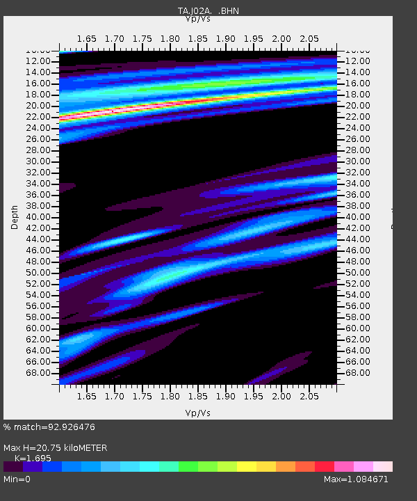
J02A Umpqua, OR, USA - Earthquake Result Viewer
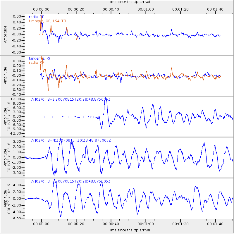
Earthquake location: Andreanof Islands, Aleutian Is.
Earthquake latitude/longitude: 50.3/-177.5
Earthquake time(UTC): 2007/08/15 (227) 20:22:11 GMT
Earthquake Depth: 9.0 km
Earthquake Magnitude: 6.3 MB, 6.2 MS, 6.4 MW, 5.9 ML
Earthquake Catalog/Contributor: WHDF/NEIC
Network: TA USArray Transportable Network (new EarthScope stations)
Station: J02A Umpqua, OR, USA
Lat/Lon: 43.37 N/123.57 W
Elevation: 136 m
Distance: 36.9 deg
Az: 79.496 deg
Baz: 300.206 deg
Ray Param: 0.07645329
Estimated Moho Depth: 20.75 km
Estimated Crust Vp/Vs: 1.70
Assumed Crust Vp: 6.522 km/s
Estimated Crust Vs: 3.848 km/s
Estimated Crust Poisson's Ratio: 0.23
Radial Match: 92.926476 %
Radial Bump: 387
Transverse Match: 84.38141 %
Transverse Bump: 400
SOD ConfigId: 2564
Insert Time: 2010-03-06 03:46:53.217 +0000
GWidth: 2.5
Max Bumps: 400
Tol: 0.001

Signal To Noise

ChannelStoNSTALTA
TA:J02A: :BHN:20070815T20:28:48.875005Z7.8433746.8337926E-78.712823E-8
TA:J02A: :BHE:20070815T20:28:48.875005Z7.99309449.115196E-71.1403838E-7
TA:J02A: :BHZ:20070815T20:28:48.875005Z23.1409872.8237152E-61.2202224E-7
Arrivals
Ps2.4 SECOND
PpPs7.9 SECOND
PsPs/PpSs10 SECOND