You are here: Home > Network List > TA - USArray Transportable Network (new EarthScope stations) Stations List
> Station J02A Umpqua, OR, USA > Earthquake Result Viewer
J02A Umpqua, OR, USA - Earthquake Result Viewer
| Earthquake location: |
Solomon Islands |
| Earthquake latitude/longitude: |
-8.0/154.6 |
| Earthquake time(UTC): |
2007/06/28 (179) 02:52:09 GMT |
| Earthquake Depth: |
10 km |
| Earthquake Magnitude: |
6.3 MB, 6.7 MS, 6.7 MW, 6.7 MW |
| Earthquake Catalog/Contributor: |
WHDF/NEIC |
|
| Network: |
TA USArray Transportable Network (new EarthScope stations) |
| Station: |
J02A Umpqua, OR, USA |
| Lat/Lon: |
43.37 N/123.57 W |
| Elevation: |
136 m |
|
| Distance: |
89.5 deg |
| Az: |
46.208 deg |
| Baz: |
258.629 deg |
| Ray Param: |
0.04181008 |
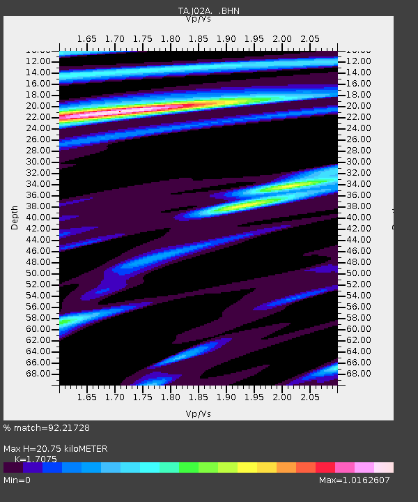
| Estimated Moho Depth: |
20.75 km |
| Estimated Crust Vp/Vs: |
1.71 |
| Assumed Crust Vp: |
6.522 km/s |
| Estimated Crust Vs: |
3.819 km/s |
| Estimated Crust Poisson's Ratio: |
0.24 |
|
| Radial Match: |
92.21728 % |
| Radial Bump: |
400 |
| Transverse Match: |
75.68497 % |
| Transverse Bump: |
400 |
| SOD ConfigId: |
2564 |
| Insert Time: |
2010-03-06 03:47:00.123 +0000 |
| GWidth: |
2.5 |
| Max Bumps: |
400 |
| Tol: |
0.001 |
|

Signal To Noise
| Channel | StoN | STA | LTA |
| TA:J02A: :BHN:20070628T03:04:35.324011Z | 1.4338799 | 2.5363167E-7 | 1.7688488E-7 |
| TA:J02A: :BHE:20070628T03:04:35.324011Z | 3.536381 | 4.8951927E-7 | 1.384238E-7 |
| TA:J02A: :BHZ:20070628T03:04:35.324011Z | 9.0447035 | 1.458937E-6 | 1.613029E-7 |
| Arrivals |
| Ps | 2.3 SECOND |
| PpPs | 8.4 SECOND |
| PsPs/PpSs | 11 SECOND |


