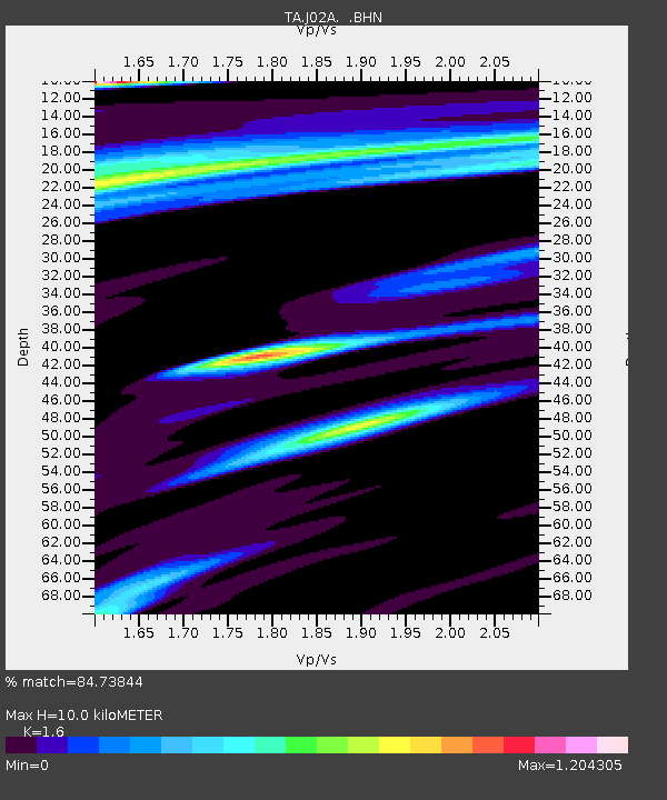
J02A Umpqua, OR, USA - Earthquake Result Viewer

Earthquake location: Fox Islands, Aleutian Islands
Earthquake latitude/longitude: 52.5/-168.0
Earthquake time(UTC): 2007/07/15 (196) 13:08:00 GMT
Earthquake Depth: 10 km
Earthquake Magnitude: 5.8 MB, 5.9 MS, 6.1 MW, 6.0 MW
Earthquake Catalog/Contributor: WHDF/NEIC
Network: TA USArray Transportable Network (new EarthScope stations)
Station: J02A Umpqua, OR, USA
Lat/Lon: 43.37 N/123.57 W
Elevation: 136 m
Distance: 30.7 deg
Az: 89.242 deg
Baz: 303.009 deg
Ray Param: 0.07925598
Estimated Moho Depth: 10.0 km
Estimated Crust Vp/Vs: 1.60
Assumed Crust Vp: 6.522 km/s
Estimated Crust Vs: 4.076 km/s
Estimated Crust Poisson's Ratio: 0.18
Radial Match: 84.73844 %
Radial Bump: 400
Transverse Match: 78.812744 %
Transverse Bump: 400
SOD ConfigId: 2564
Insert Time: 2010-03-06 03:47:17.369 +0000
GWidth: 2.5
Max Bumps: 400
Tol: 0.001

Signal To Noise

ChannelStoNSTALTA
TA:J02A: :BHN:20070715T13:13:45.273013Z2.01049692.1653292E-71.07701204E-7
TA:J02A: :BHE:20070715T13:13:45.273013Z3.17175152.6927424E-78.489766E-8
TA:J02A: :BHZ:20070715T13:13:45.273013Z3.6458096.258703E-71.7166843E-7
Arrivals
Ps1.0 SECOND
PpPs3.6 SECOND
PsPs/PpSs4.6 SECOND