You are here: Home > Network List > TA - USArray Transportable Network (new EarthScope stations) Stations List
> Station J02A Umpqua, OR, USA > Earthquake Result Viewer
J02A Umpqua, OR, USA - Earthquake Result Viewer
| Earthquake location: |
Solomon Islands |
| Earthquake latitude/longitude: |
-8.5/157.0 |
| Earthquake time(UTC): |
2007/04/01 (091) 20:39:56 GMT |
| Earthquake Depth: |
10 km |
| Earthquake Magnitude: |
6.8 MB, 7.9 MS, 8.1 MW, 7.7 ME |
| Earthquake Catalog/Contributor: |
WHDF/NEIC |
|
| Network: |
TA USArray Transportable Network (new EarthScope stations) |
| Station: |
J02A Umpqua, OR, USA |
| Lat/Lon: |
43.37 N/123.57 W |
| Elevation: |
136 m |
|
| Distance: |
88.1 deg |
| Az: |
45.823 deg |
| Baz: |
256.618 deg |
| Ray Param: |
0.042828854 |
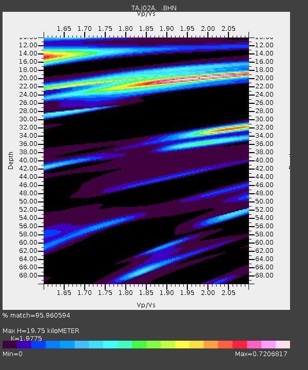
| Estimated Moho Depth: |
19.75 km |
| Estimated Crust Vp/Vs: |
1.98 |
| Assumed Crust Vp: |
6.522 km/s |
| Estimated Crust Vs: |
3.298 km/s |
| Estimated Crust Poisson's Ratio: |
0.33 |
|
| Radial Match: |
95.960594 % |
| Radial Bump: |
285 |
| Transverse Match: |
88.60539 % |
| Transverse Bump: |
400 |
| SOD ConfigId: |
2564 |
| Insert Time: |
2010-03-06 03:47:20.860 +0000 |
| GWidth: |
2.5 |
| Max Bumps: |
400 |
| Tol: |
0.001 |
|

Signal To Noise
| Channel | StoN | STA | LTA |
| TA:J02A: :BHN:20070401T20:52:15.575007Z | 2.9377298 | 3.6718728E-7 | 1.2499014E-7 |
| TA:J02A: :BHE:20070401T20:52:15.575007Z | 1.9174547 | 5.540629E-7 | 2.889575E-7 |
| TA:J02A: :BHZ:20070401T20:52:15.575007Z | 4.4430203 | 1.9406205E-6 | 4.3677954E-7 |
| Arrivals |
| Ps | 3.0 SECOND |
| PpPs | 8.8 SECOND |
| PsPs/PpSs | 12 SECOND |


