You are here: Home > Network List > TA - USArray Transportable Network (new EarthScope stations) Stations List
> Station J02A Umpqua, OR, USA > Earthquake Result Viewer
J02A Umpqua, OR, USA - Earthquake Result Viewer
| Earthquake location: |
Near Coast Of Peru |
| Earthquake latitude/longitude: |
-13.5/-76.7 |
| Earthquake time(UTC): |
2006/10/20 (293) 10:48:56 GMT |
| Earthquake Depth: |
23 km |
| Earthquake Magnitude: |
5.9 MB, 6.6 MS, 6.7 MW, 6.6 MW |
| Earthquake Catalog/Contributor: |
WHDF/NEIC |
|
| Network: |
TA USArray Transportable Network (new EarthScope stations) |
| Station: |
J02A Umpqua, OR, USA |
| Lat/Lon: |
43.37 N/123.57 W |
| Elevation: |
136 m |
|
| Distance: |
70.9 deg |
| Az: |
325.711 deg |
| Baz: |
131.274 deg |
| Ray Param: |
0.05462498 |
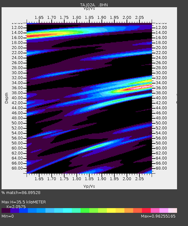
| Estimated Moho Depth: |
35.5 km |
| Estimated Crust Vp/Vs: |
2.06 |
| Assumed Crust Vp: |
6.522 km/s |
| Estimated Crust Vs: |
3.17 km/s |
| Estimated Crust Poisson's Ratio: |
0.35 |
|
| Radial Match: |
86.89528 % |
| Radial Bump: |
400 |
| Transverse Match: |
86.1464 % |
| Transverse Bump: |
391 |
| SOD ConfigId: |
2665 |
| Insert Time: |
2010-03-06 03:47:35.907 +0000 |
| GWidth: |
2.5 |
| Max Bumps: |
400 |
| Tol: |
0.001 |
|

Signal To Noise
| Channel | StoN | STA | LTA |
| TA:J02A: :BHN:20061020T10:59:40.249014Z | 1.0692173 | 3.4144722E-7 | 3.1934314E-7 |
| TA:J02A: :BHE:20061020T10:59:40.249014Z | 1.278292 | 3.238944E-7 | 2.5338062E-7 |
| TA:J02A: :BHZ:20061020T10:59:40.249014Z | 2.4108403 | 1.1275628E-6 | 4.6770532E-7 |
| Arrivals |
| Ps | 5.9 SECOND |
| PpPs | 16 SECOND |
| PsPs/PpSs | 22 SECOND |


