You are here: Home > Network List > TA - USArray Transportable Network (new EarthScope stations) Stations List
> Station J02A Umpqua, OR, USA > Earthquake Result Viewer
J02A Umpqua, OR, USA - Earthquake Result Viewer
| Earthquake location: |
Kuril Islands |
| Earthquake latitude/longitude: |
46.5/153.2 |
| Earthquake time(UTC): |
2006/10/01 (274) 09:06:02 GMT |
| Earthquake Depth: |
19 km |
| Earthquake Magnitude: |
6.1 MB, 6.4 MS, 6.6 MW, 6.5 MW |
| Earthquake Catalog/Contributor: |
WHDF/NEIC |
|
| Network: |
TA USArray Transportable Network (new EarthScope stations) |
| Station: |
J02A Umpqua, OR, USA |
| Lat/Lon: |
43.37 N/123.57 W |
| Elevation: |
136 m |
|
| Distance: |
56.3 deg |
| Az: |
60.46 deg |
| Baz: |
304.459 deg |
| Ray Param: |
0.06418562 |
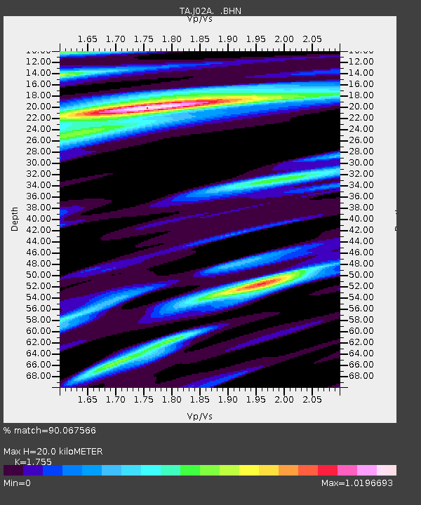
| Estimated Moho Depth: |
20.0 km |
| Estimated Crust Vp/Vs: |
1.75 |
| Assumed Crust Vp: |
6.522 km/s |
| Estimated Crust Vs: |
3.716 km/s |
| Estimated Crust Poisson's Ratio: |
0.26 |
|
| Radial Match: |
90.067566 % |
| Radial Bump: |
337 |
| Transverse Match: |
64.06753 % |
| Transverse Bump: |
400 |
| SOD ConfigId: |
2665 |
| Insert Time: |
2010-03-06 03:47:39.438 +0000 |
| GWidth: |
2.5 |
| Max Bumps: |
400 |
| Tol: |
0.001 |
|

Signal To Noise
| Channel | StoN | STA | LTA |
| TA:J02A: :BHN:20061001T09:15:10.950005Z | 1.7249744 | 5.1948564E-7 | 3.0115555E-7 |
| TA:J02A: :BHE:20061001T09:15:10.950005Z | 0.9868653 | 3.2086538E-7 | 3.2513594E-7 |
| TA:J02A: :BHZ:20061001T09:15:10.950005Z | 3.4112704 | 9.285913E-7 | 2.7221273E-7 |
| Arrivals |
| Ps | 2.4 SECOND |
| PpPs | 8.0 SECOND |
| PsPs/PpSs | 10 SECOND |


