You are here: Home > Network List > TA - USArray Transportable Network (new EarthScope stations) Stations List
> Station J02A Umpqua, OR, USA > Earthquake Result Viewer
J02A Umpqua, OR, USA - Earthquake Result Viewer

| Earthquake location: |
Eastern Siberia, Russia |
| Earthquake latitude/longitude: |
60.9/167.1 |
| Earthquake time(UTC): |
2006/04/20 (110) 23:25:02 GMT |
| Earthquake Depth: |
22 km |
| Earthquake Magnitude: |
6.8 MB, 7.6 MS, 7.6 MW, 7.3 MW |
| Earthquake Catalog/Contributor: |
WHDF/NEIC |
|
| Network: |
TA USArray Transportable Network (new EarthScope stations) |
| Station: |
J02A Umpqua, OR, USA |
| Lat/Lon: |
43.37 N/123.57 W |
| Elevation: |
136 m |
|
| Distance: |
43.7 deg |
| Az: |
80.897 deg |
| Baz: |
318.637 deg |
| Ray Param: |
0.07233873 |
| Estimated Moho Depth: |
20.0 km |
| Estimated Crust Vp/Vs: |
1.72 |
| Assumed Crust Vp: |
6.522 km/s |
| Estimated Crust Vs: |
3.786 km/s |
| Estimated Crust Poisson's Ratio: |
0.25 |
|
| Radial Match: |
93.45052 % |
| Radial Bump: |
296 |
| Transverse Match: |
83.44857 % |
| Transverse Bump: |
400 |
| SOD ConfigId: |
2669 |
| Insert Time: |
2010-03-06 03:47:58.321 +0000 |
| GWidth: |
2.5 |
| Max Bumps: |
400 |
| Tol: |
0.001 |
|
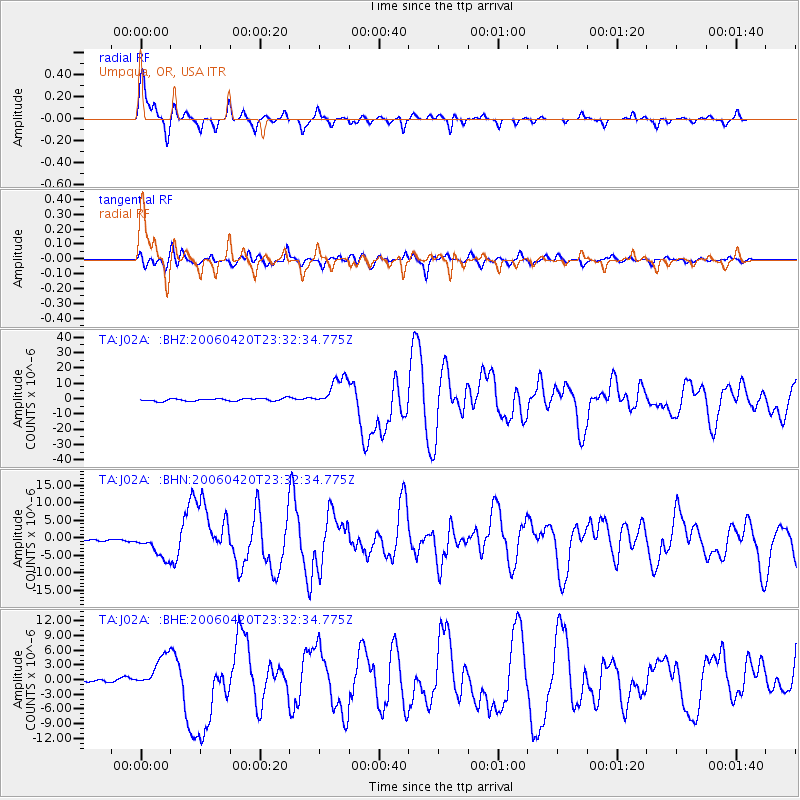
Signal To Noise
| Channel | StoN | STA | LTA |
| TA:J02A: :BHN:20060420T23:32:34.775Z | 5.918992 | 3.7966058E-6 | 6.4142773E-7 |
| TA:J02A: :BHE:20060420T23:32:34.775Z | 6.6489587 | 3.5716687E-6 | 5.3717713E-7 |
| TA:J02A: :BHZ:20060420T23:32:34.775Z | 11.819617 | 9.8948285E-6 | 8.37153E-7 |
| Arrivals |
| Ps | 2.4 SECOND |
| PpPs | 7.8 SECOND |
| PsPs/PpSs | 10 SECOND |


