You are here: Home > Network List > TA - USArray Transportable Network (new EarthScope stations) Stations List
> Station J02A Umpqua, OR, USA > Earthquake Result Viewer
J02A Umpqua, OR, USA - Earthquake Result Viewer
| Earthquake location: |
South Of Fiji Islands |
| Earthquake latitude/longitude: |
-23.6/-180.0 |
| Earthquake time(UTC): |
2006/02/26 (057) 03:08:27 GMT |
| Earthquake Depth: |
535 km |
| Earthquake Magnitude: |
5.9 MB, 6.4 MW, 6.4 MW |
| Earthquake Catalog/Contributor: |
WHDF/NEIC |
|
| Network: |
TA USArray Transportable Network (new EarthScope stations) |
| Station: |
J02A Umpqua, OR, USA |
| Lat/Lon: |
43.37 N/123.57 W |
| Elevation: |
136 m |
|
| Distance: |
84.4 deg |
| Az: |
37.622 deg |
| Baz: |
230.159 deg |
| Ray Param: |
0.043979503 |
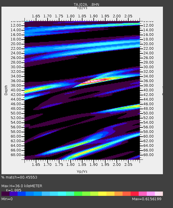
| Estimated Moho Depth: |
36.0 km |
| Estimated Crust Vp/Vs: |
1.88 |
| Assumed Crust Vp: |
6.522 km/s |
| Estimated Crust Vs: |
3.46 km/s |
| Estimated Crust Poisson's Ratio: |
0.30 |
|
| Radial Match: |
80.45553 % |
| Radial Bump: |
350 |
| Transverse Match: |
74.53218 % |
| Transverse Bump: |
369 |
| SOD ConfigId: |
2422 |
| Insert Time: |
2010-03-06 03:48:02.338 +0000 |
| GWidth: |
2.5 |
| Max Bumps: |
400 |
| Tol: |
0.001 |
|

Signal To Noise
| Channel | StoN | STA | LTA |
| TA:J02A: :BHN:20060226T03:19:32.525027Z | 1.9133732 | 6.778665E-7 | 3.5427823E-7 |
| TA:J02A: :BHE:20060226T03:19:32.525027Z | 1.9063557 | 8.597735E-7 | 4.510037E-7 |
| TA:J02A: :BHZ:20060226T03:19:32.525027Z | 11.834514 | 4.3515224E-6 | 3.676976E-7 |
| Arrivals |
| Ps | 5.0 SECOND |
| PpPs | 16 SECOND |
| PsPs/PpSs | 21 SECOND |


